

Summer Mix Of Sun And Storms
EARLY THIS MORNING: Unlike yesterday morning, the radar is quiet across North/Central Alabama at daybreak with temperatures are mostly in the low 70s. We have the same upper air configuration across the nation; a hot ridge over the western states, and a deep upper trough over the east. Winds aloft over Alabama are from the northwest, and this will bring occasional disturbances down this way in coming days.
We note an MCS (Mesoscale Convective System) in progress over southern Missouri moving southeast, and this feature could impact North Alabama later today.
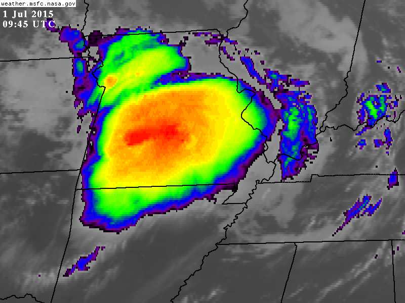
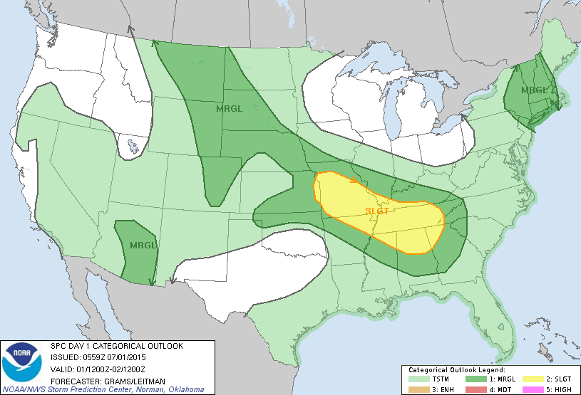
The guys at the Storm Prediction Center have much of North Alabama under the standard “slight risk” of severe weather later today and tonight as this MCS approaches; the main threat will come from small areas of strong straight line winds (wet microbursts). And, of course, all summer storms are packed with lightning.
The sun will be out at times today, and we expect a high generally in the mid 80s, below average for the first day of July in Alabama.
TOMORROW AND THE HOLIDAY WEEKEND: The overall weather pattern just won’t change much. Moist air in place, a northwest flow aloft, and the daily risk of a few passing showers or thunderstorms. While the best chance of rain will come during the afternoon and evening hours, we can’t rule out a late night or morning thunderstorm in this situation. Unfortunately it is impossible to give you specific start/stop times of the rain… just be prepared for a passing shower or storm at any hour through the weekend.
On the positive side, there will be some very nice breaks in the rain, and the sun will be out at times. And, temperatures will be pretty nice for the Fourth of July, with highs only in the 80s. We all know we can have triple digit heat this time of the year.
NEXT WEEK: An upper ridge will begin to slowly build, and by mid-week we expect increasing amounts of sun, hotter afternoons, and fewer showers and thunderstorms. See the Weather Xtreme video for maps, graphics, and more details.
AT THE BEACH: Very typical weather for the Central Gulf Coast (Panama City Beach west to Gulf Shores) through the holiday weekend… about 7 to 9 hours of sunshine each day, with the routine risk of a passing storm from time to time. Highs on the immediate coast will be in the mid to upper 80s, with low 90s inland. The sea water temperature early this morning at the Dauphin Island Sea Lab is 82 degrees.
TROPICS: No risk of any tropical storms or hurricanes in the Atlantic basin over the next five to seven days.
SMOKE FROM A DISTANT FIRE: Smoke from large wildfires in western Canada arrived in Alabama yesterday…

That smoke gave the moon a red/orange look last night in the Alabama sky.

WEATHER BRAINS: Don’t forget you can listen to our weekly 90 minute netcast anytime on the web, or on iTunes. This is the show all about weather featuring many familiar voices, including our meteorologists here at ABC 33/40.
CONNECT: You can find me on all of the major social networks…
Facebook
Twitter
Google Plus
Instagram
Look for the next Weather Xtreme video here by 4:00 this afternoon… enjoy the day…
Category: Alabama's Weather
About the Author (Author Profile)
James Spann is one of the most recognized and trusted television meteorologists in the industry. He holds the AMS CCM designation and television seals from the AMS and NWA. He is a past winner of the Broadcast Meteorologist of the Year from both professional organizations.Subscribe
If you enjoyed this article, subscribe to receive more just like it.


