

Heat Cranks Up
Short Version: Repeat yesterdays discussion and weather!
A little tongue in cheek there with the fact that the overall weather pattern is not changing much as heat levels gradually climb and parts of Central Alabama come under heat advisories for the next couple of days.
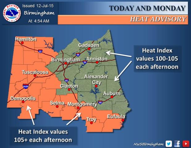 Graphic from NWS Birmingham.
Another warm morning to start the day in Central Alabama with temperatures starting out in the lower and middle 70s. Few clouds were noted, but most of them were of the high variety so not expecting clouds to be much help with the heat. The NWS has posted a heat advisory for today and Monday for a fairly large chunk of Central Alabama generally south and west of Birmingham including Montgomery, Selma, Tuscaloosa, and Hamilton. With little change expected in the upper air pattern, heat indices of 105 degrees or just above will be possible through much of the week ahead, so the heat advisory may be expanded in time.
With the upper ridge centered just to our west, much of the action in the weather will continue along the northeastern periphery of the ridge with a series of short waves moving through the westerly flow and keeping a good deal of serious weather just to our north and northeast. SPC has outlined a moderate risk for severe thunderstorms for Day 1 and 2 in the Upper Midwest and into the Ohio Valley. Day 3, Tuesday, sees an enhanced risk for severe storms over parts of the Southeast US centered primarily on East Tennessee and affecting parts of northern Alabama. This risk area may have to be adjusted slightly depending on the actual movement of the upper ridge.
Heat levels might drop a bit Tuesday and Wednesday due to slightly better rain chances along with the presence of more clouds. But the ridge moves back and strengthens again on Wednesday and Thursday as the westerlies are pushed northward once again with the ebb and flow of the large upper ridge.
But hold on! While the upper ridge positioned over Texas will be the primary feature affecting our weather pattern, the GFS is suggesting another pattern change similar to what we saw in June. As we head out into voodoo country, the GFS is developing another fairly deep trough across the eastern third of the US which if it develops would definitely spell some relief to our hot pattern while the Southwest and West would get warm again. Definitely something to keep our eyes on the evolution of this change.
The Atlantic Basin remains quiet with just a small area of cloudiness off the North Carolina coast which is not expected to develop much as it moves away from the coast. Dolores has come into play in the Eastern Pacific and could develop into a major hurricane toward the latter part of the week as it remains away from land. And Typhoon Chan-Hom, now a tropical storm, skirted by the coast of China yesterday and is weakening as it moves toward the Korean Peninsula.
Beach goers will see a few passing showers and storms as a daily occurrence, but away from these passing storms, you can expect 7 to 10 hours of sunshine each day from Dauphin Island east to Panama City Beach today and into much the week ahead. Highs on the immediate coast will be in the upper 80s, with lower 90s inland. The water temperature at the Dauphin Island Sea Lab was reported as a very balmy 90 degrees.
James Spann will be back with the next edition of the Weather Xtreme Video on Monday morning. While the current heat is not overly extreme, it is best to use common sense and factor the heat into your planned activities by not overdoing it while working or playing outside.
-Brian-
Category: Alabama's Weather
About the Author (Author Profile)
Brian Peters is one of the television meteorologists at ABC3340 in Birmingham and a retired NWS Warning Coordination Meteorologist. He handles the weekend Weather Xtreme Videos and forecast discussion and is the Webmaster for the popular WeatherBrains podcast.Subscribe
If you enjoyed this article, subscribe to receive more just like it.


