

A Few Scattered Storms Later Today
WILD NIGHT: A line of severe storms rolled through North Alabama last night, with winds of 50-70 mph, knocking down countless trees and power lines. One person was killed by a falling tree near West Point in Cullman County, and at one point over 100,000 were without power in areas served by Alabama Power, rural co-ops, and the TVA. Severe thunderstorm warnings were issued well in advance of the arrival of these storms; the NWS did their usual fine work. The risk was also defined early in the day (and, really, days in advance) by the Storm Prediction Center, and a severe thunderstorm watch was issued for the northern part of the state at 4:00 yesterday afternoon.
Last night’s event is a reminder that you really, really need to pay attention to severe thunderstorm warnings.
THE DAY AHEAD: The weather is calm this morning, but we expect scattered thunderstorms to form this afternoon during the heat of the day. Nothing organized like last night, but where storms do develop they will be strong; SPC has much of the state in a “marginal” severe weather risk…
Most of the storms will form between 1:00 and 8:00 p.m., and the chance of any one spot getting wet is about one in three. Otherwise, the day will be hot and humid with a high in the mid 90s.
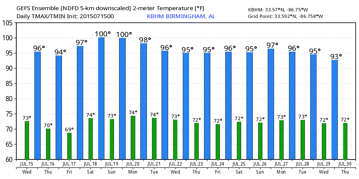
TOMORROW THROUGH THE WEEKEND: The upper ridge strengthens, and the warm air aloft associated with the ridge will keep storms few and far between. Expect hazy sunshine all four days, and daily highs will be in the 97 to 100 degree range. Looks like the hottest weekend of the year; the GEFS ensemble is suggesting 100 degree heat potential for Birmingham…
NEXT WEEK: Global models suggest the ridge will weaken a bit, with heat levels dropping a bit by mid-week with a slightly higher coverage of afternoon thunderstorms. Still, highs stay in the 90s. See the Weather Xtreme video for maps, graphics, and more details.
AT THE BEACH: Mostly sunny days, fair nights on the coast from Panama City Beach west to Gulf Shores through most of next week with the usual risk of a passing storm from time to time; highs on the immediate coast will be in the upper 80s, with mid 90s inland. Sea water temperatures are mostly in the mid 80s.
TROPICS: Claudette is now post-tropical, and approaching Nova Scotia. The rest of the Atlantic basin is very quiet, and tropical storm formation is not expected this week.
WEATHER BRAINS: Don’t forget you can listen to our weekly 90 minute netcast anytime on the web, or on iTunes. This is the show all about weather featuring many familiar voices, including our meteorologists here at ABC 33/40.
CONNECT: You can find me on all of the major social networks…
Facebook
Twitter
Google Plus
Instagram
I will be doing a safety meeting today for ALAGASCO in Gadsden… look for the next Weather Xtreme video here by 4:00 this afternoon… enjoy the day!
Category: Alabama's Weather
About the Author (Author Profile)
James Spann is one of the most recognized and trusted television meteorologists in the industry. He holds the AMS CCM designation and television seals from the AMS and NWA. He is a past winner of the Broadcast Meteorologist of the Year from both professional organizations.Subscribe
If you enjoyed this article, subscribe to receive more just like it.


