

Concerning Last Night…
Some thoughts about the fast moving line of thunderstorms that brought countless downed trees and power lines across North Alabama, and one weather related fatality in Cullman County due to a falling tree.
It was a well forecast event with excellent and timely severe weather watches and warnings, but over and over last night I heard from people that “had no clue” this was going to happen, and the storms “came out of nowhere”.
Let me say up front I fully understand people are busy, and most are not “weather geeks” that follow every blog post and keep eyes glued to the radar. But, everyone should have received warnings well before the storms arrived last night.
TIMELINE: The guys at the Storm Prediction Center placed North Alabama in a severe weather risk for Tuesday/Tuesday night on their convective outlooks back on Sunday morning. They identified the risk more than 48 hours in advance, and we did our best to communicate that risk across all of our forecast products here on the blog, and on TV, radio, and social media.
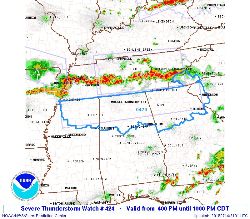
WATCH: The first severe thunderstorm watch was issued at 4:00 yesterday afternoon for North Alabama, well ahead of the line of severe storms that was over Tennessee at the time.
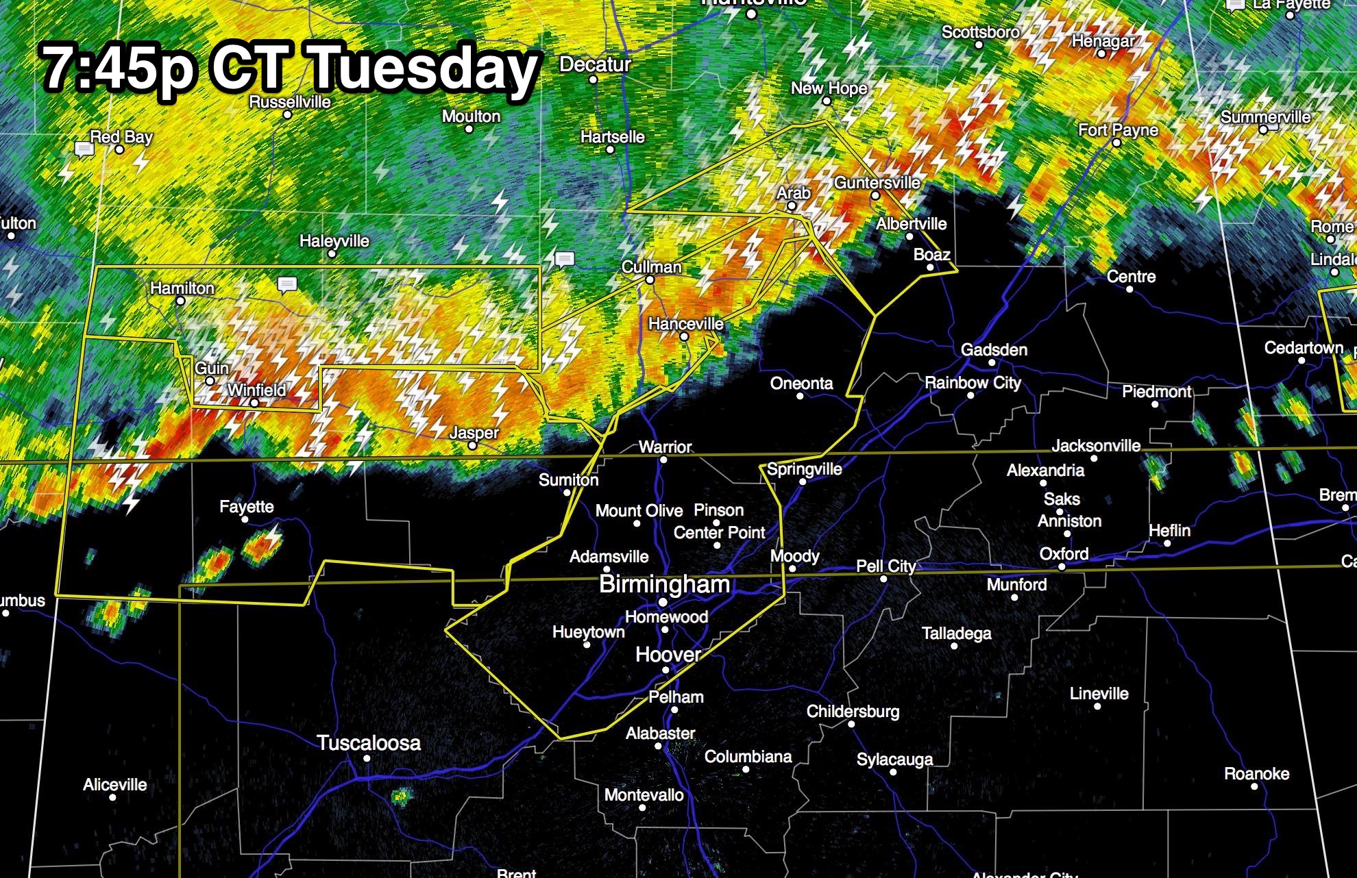
WARNINGS: Timely severe thunderstorm warnings were issued by NWS offices in Huntsville and Birmingham for the entire event, clearly stating the risk of wind gusts to 70 mph. This was what the radar looked like at 7:45 last night; note Jefferson County was under a warning well before the storms and the wind arrived.
So, why in the world would people be surprised?
*Inability to get warnings. Way, way too many people in our state don’t have a NOAA Weather Radio, and for those with smart phones, they don’t have a good app designed to deliver timely warnings. There are literally hundreds and hundreds of the standard free “crap apps”, but a little picture of a storm cloud and a high/low/chance of rain won’t help you when the weather turns severe. The two apps I like that work well are “Weather Radio by WDT”, and “MyWarn”. They work very well, and you won’t miss warnings.
*Some don’t pay attention to severe thunderstorm warnings. Sure, there is a good chance a tornado warning will get your attention, but for some reason people often just don’t pay attention to other warnings. Let me encourage you to listen carefully to what the warning says before you blow it off. So much of the damage in our state is caused by straight line winds, not tornadoes. Last night is a prime example.
If you read this blog on a regular basis (and, thank you!), we are preaching to the choir. You know what is going on, and you stay informed. We just have to get everyone else to pay better attention when severe weather is a threat to Alabama. The physical science is amazingly good during active storms, with timely watches and warnings. No, we can’t promise a warning for every severe storm and tornado, but you will get one in almost every case.
SOCIAL MEDIA: I have about 235,000 people that follow my Facebook page, but please remember when warnings are posted there, it reaches only a small percentage of the newsfeeds of those that follow. It is just the way Facebook works, and nothing I can do about it.

And, for those that are reached, after I post a radar or warning update, the usual questions follow about specific spots. “What about Blount, Winston, Cullman, Walker, Jasper, Gadsden, Trussville, etc etc etc (you can list any other community or county)”. Needless to say, I can’t mention every town with a widespread wind damage event like last night. Everyone was impacted, and the answer to 90 percent of the questions posted there can be answered with a quick check of this blog. Our posts are usually short, to the point, and it doesn’t take long to read.
I promise I do my best to engage with the social media followers, post updates, and answer questions. You would not believe the time I spend on social media, and I am so thankful for the two-way communication and the volume of reports and pictures I receive.
But, remember this is the place where you get the most consistent, timely, and reliable information. Please bookmark the blog and check it often. Bill Murray, Ryan Stinnett, and the rest of the gang here do a phenomenal job while we are on TV. You don’t get this in many other markets in the U.S.
TWITTER: If you want a running feed of warnings, updates, pictures, and reports from the public, following my Twitter feed is the way to go. There is no filtering like Facebook.
JAMES SPANN APP: As posted here several weeks ago, the James Spann 24/7 app has gone away. Unfortunately there is nothing I can do about it, but a new app will be available soon from ABC 33/40 with all of the elements in the old app, along with all of our other news and sports content. But you can access the blog from any browser on any smart phone.
But the bottom line is that you have to have a good, reliable way of getting severe weather warnings, and pay attention to what we are saying when they are issued. Then, you won’t be caught off guard and dealing with storms “out of nowhere”!
Category: Alabama's Weather
About the Author (Author Profile)
James Spann is one of the most recognized and trusted television meteorologists in the industry. He holds the AMS CCM designation and television seals from the AMS and NWA. He is a past winner of the Broadcast Meteorologist of the Year from both professional organizations.Subscribe
If you enjoyed this article, subscribe to receive more just like it.


