

Another Hot & Humid Day
James is in St. Louis on this Tuesday, so we will operate with an abbreviated video schedule today. Just one Weather Xtreme video today. We will return to regular schedule tomorrow when James gets back.
FOR YOUR TUESDAY: It will be very similar to Monday across the state. Highs today will climb well into the 90s and there will be a mix of sun and clouds. As we saw yesterday, a weak moisture axis along the Intestate 20 corridor allowed shower and storms to develop and they produced heavy rainfall across the Birmingham Metro. The Birmingham Airport received 1.26″ of rain yesterday, while other portions of the Metro area stayed dry. The moisture axis shifts a little farther south today, so the main convection is expected to be between the Intestate 20 and Interstate 85 corridors. These storms will be only heat relief today, so if you see the rain, consider yourself lucky.
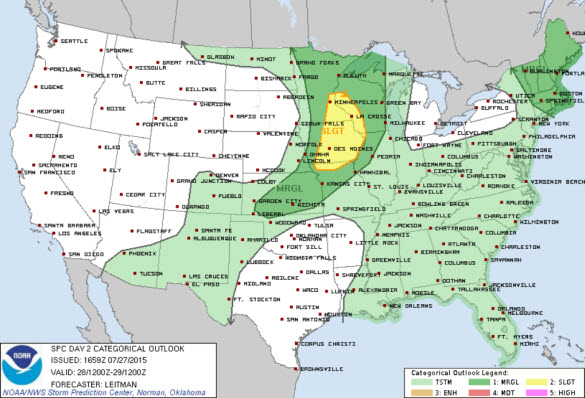
TODAY’S SEVERE WEATHER OUTLOOK: Our friends at the SPC have issued a “slight” risk of severe storms today across the Upper Midwest, which is surrounded by the standard “marginal” risk that includes the rest of the Upper Midwest, Great Lakes, and Central Plains. There is also a “marginal” risk for much of New England. The main threat will come from damaging winds, and hail but a few tornadoes may be possible with the storms in the Midwest. For Alabama, we are highlighted in a general thunderstorm outlook, which is what we expect most days this time of year.
TOPIC TROPICS: We are still watching a a broad area of low pressure along the west coast of Florida just north of Tampa. We know from history, that the longer an area of low pressure sits somewhere, the better the chances of it developing. However, the NHC is not expecting any tropical cyclone development over the next 48 hours. Of course, we will be watching to see if this by chance becomes Danny later this week, but as of now, the NHC is not overly concerned. This feature and the associated unsettled weather are making for rather wet weather across much of the Florida Peninsula this week…Stay tuned!!!
AT THE BEACH: For today, expect fantastic beach weather to continue. It will be another hot day with afternoon highs climbing into the lower 90s, but just a few miles inland, highs will climb into the mid and upper 90s. Rain chances will remain rather low today, but an isolated storm or two will be possible, but most of the beaches will stay dry today. After today, the weather will begin to change some as rain chance will be increasing some and those isolated storms become more numerous and scattered. See the complete Gulf Coast 7 Day Planner here . The Gulf Coast Beach Forecast is presented by Gulf Shores Plantation by Mandoki Hospitality Vacation Rentals. Escape to Gulf Shores Plantation where memories last a lifetime.
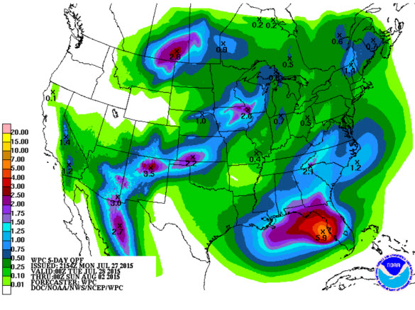
WEDNESDAY-FRIDAY: Rain chance will be in the way up for the second half of the week. We are forecasting hot & very humid days, highs in the low to mid 90s, and the risk of scattered showers and storms, mostly during the afternoon and evening hours. We do expect an increase in the number of showers and storms by Thursday, as a surface front approaches the state and then stalls out somewhere likely near the Interstate 85 corridor. This front will be enhancing the uplift across the region and this will certainly help for more widespread shower and thunderstorm activity. By Friday, we should see a bulk of the convection pushing towards the south. QPF output over the next five days has much of Central Alabama receiving anywhere from one half to one inch of rain.
THE ALABAMA WEEKEND: Depending how far south the boundary makes it will determine the weather for your location this weekend. Model data shows the boundary stalling out near the Interstate 85 corridor. To the north of the boundary, dry and sunny weather, while along and south of the boundary, expect rainy conditions. A summer frontal boundary is hard to forecast for the Deep South this time of year as they are rare and because we are not exactly sure how far south it will make it. Going with model persistence, expect more sun than clouds for North-Central Alabama and highs should be in the lower 90s.
James will be back with the regular morning and afternoon videos on Wednesday. Stay cool!
Category: Alabama's Weather
About the Author (Author Profile)
Macon, Georgia Television Chief Meteorologist, Birmingham native, and long time Contributor on AlabamaWX. Stormchaser. I did not choose Weather, it chose Me. College Football Fanatic. @Ryan_StinnetSubscribe
If you enjoyed this article, subscribe to receive more just like it.


