

Wet At Times Through Tomorrow
RADAR CHECK: As the sun comes up the sky is mostly cloudy across the great state of Alabama, and there are a few patches of light rain on radar, but nothing widespread. The overall wet weather pattern will continue through tomorrow with a very moist airmass in place (precipitable water values near 2 inches)… we will forecast occasional showers and thunderstorms with generally cloudy conditions along with highs in the 80s.
We do note that SPC has placed much of North Alabama in a “marginal” severe weather risk for this afternoon and tonight…
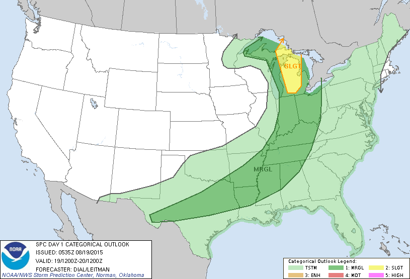
A very dynamic, autumn looking upper trough will pass well to the north of us, pushing a surface boundary closer to our state. The main threat from the storms this afternoon and early tonight will come from strong straight line winds. And, we all know summer storms pack gobs of lightning.
The front will be just north of Alabama tomorrow, but the upper support will lift well north of here, so organized severe weather is not expected then. But, a few showers and storms are likely during the day.
FRIDAY AND THE WEEKEND: The weather trends drier. Models try to bring the surface front down toward I-20 Friday, meaning the day should be mostly dry north of Birmingham, with scattered showers and storms continuing to the south. Then, over the weekend, we expect a pretty decent amount of sunshine Saturday and Sunday with only widely scattered showers and storms; afternoon highs will be close to 90 degrees both days.
NEXT WEEK: It looks pretty quiet around here; partly to mostly sunny days, fair nights, and only widely scattered afternoon and evening showers and thunderstorms. Highs will stay close to 90; see the Weather Xtreme video for maps, graphics, and more details.
AT THE BEACH: About 3 to 5 hours of sunshine on the coast today and tomorrow from Gulf Shores west to Panama City Beach, followed by increasing amounts of sunshine over the weekend. As usual this time of the year, you will deal with a passing storm from time to time. Highs on the coast will be in the mid to upper 80s, and closer to 90 inland. The sea water temperature early this morning at the Dauphin Island Sea Lab is 84 degrees.
TROPICAL STORM DANNY: Danny boy looks a little disorganized this morning, but sustained winds are still estimated at 50 mph as the system moves west/northwest. It is expected to become a hurricane tomorrow, and be somewhere close to the Leeward Islands early next week.
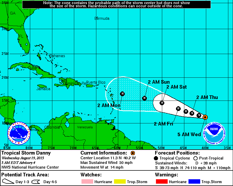
We note the GEFS ensemble (at least most members) recurve Danny into the open Atlantic next week. The idea seems plausible based on the upper air pattern and climatology, but this is not “carved in stone”. We will be watching closely in coming days.

WEATHER BRAINS: Don’t forget you can listen to our weekly 90 minute netcast anytime on the web, or on iTunes. This is the show all about weather featuring many familiar voices, including our meteorologists here at ABC 33/40.
CONNECT: You can find me on all of the major social networks…
Facebook
Twitter
Google Plus
Instagram
Look for the next Weather Xtreme video here by 4:00 this afternoon… enjoy the day!
Category: Alabama's Weather
About the Author (Author Profile)
James Spann is one of the most recognized and trusted television meteorologists in the industry. He holds the AMS CCM designation and television seals from the AMS and NWA. He is a past winner of the Broadcast Meteorologist of the Year from both professional organizations.Subscribe
If you enjoyed this article, subscribe to receive more just like it.


