

Strong Storms Across Alabama
RADAR CHECK: A number of strong thunderstorms have formed across Alabama this afternoon; heavier ones are producing gusty winds, torrential rain, and lots of lightning as they move northeast…
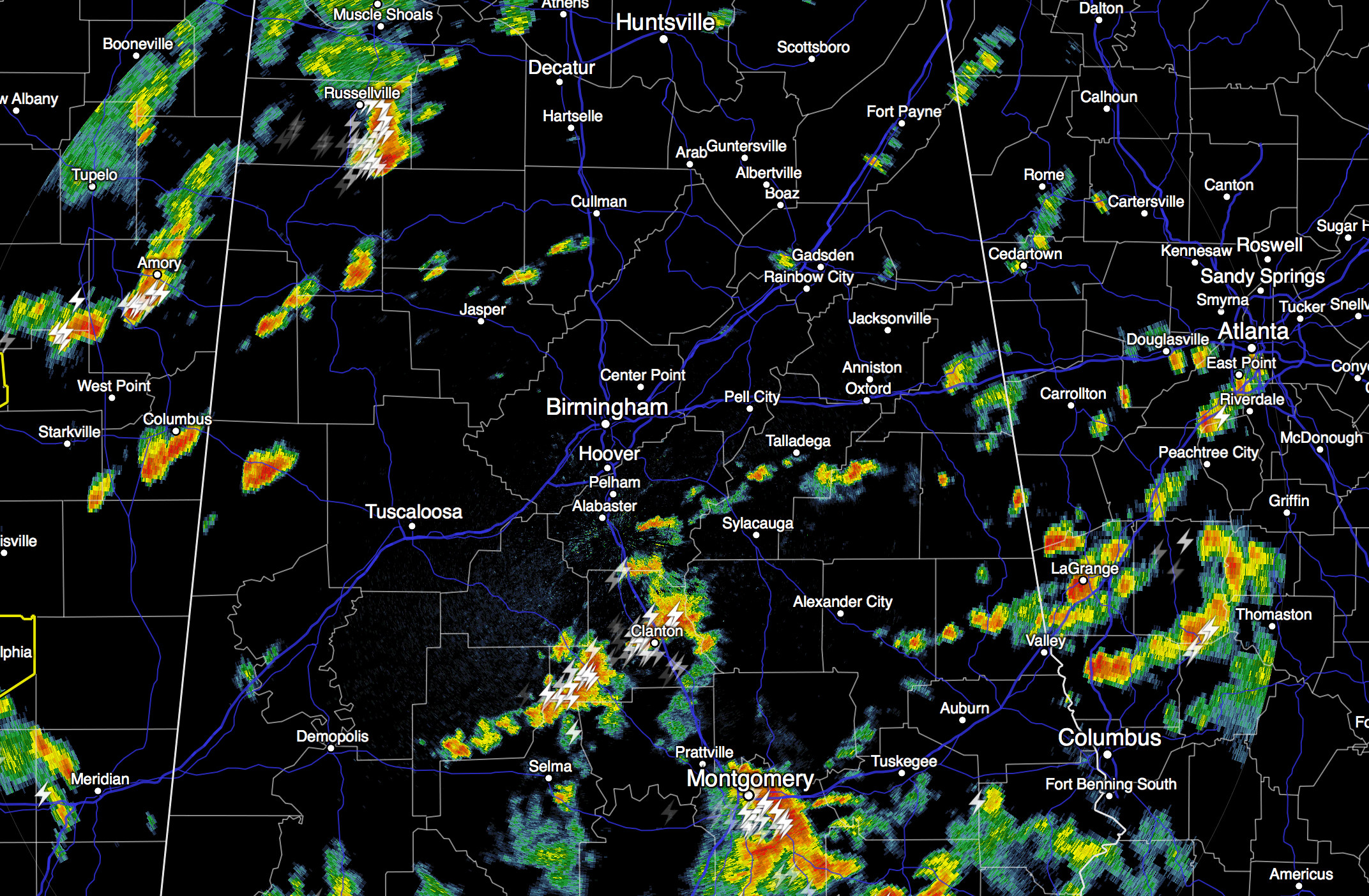
SPC has a the standard “slight risk” of severe weather defined for the northwest corner of the state, with a “marginal” risk down to about U.S. 278 (Hamilton to Cullman to Gadsden). A few severe thunderstorm warnings could be required over the next few hours.
TOMORROW: A deep upper trough will be lifting up into Canada, and a surface front will approach the northwest corner of Alabama. Behind the front, cool air will spread down into states like Oklahoma, Missouri, and Arkansas. Some communities in Northwest Arkansas could reach the upper 40s early tomorrow morning. We will stay in warm, moist air, however, and again we will deal with scattered to numerous showers and thunderstorms with a high in the 80s.
TRENDING DRIER FRIDAY AND OVER THE WEEKEND: Dry air begins to drop down into North Alabama, and by Friday the best coverage of showers and storms will shift down to areas along and south of I-20, and even there they will be scattered in nature. The high Friday will be in the 87 to 90 degree range.
Then, for the weekend. we project a good supply of sunshine Saturday and Sunday across North/Central Alabama with only widely scattered, mostly afternoon and evening showers and thunderstorms. The high Saturday and Sunday will be at or just over 90 degrees.
NEXT WEEK: Not big changes Monday, but on Tuesday a surface front will pass through the state, and that could kick off a few showers or storms. Then, a dry, continental airmass is expected to arrive Tuesday night, setting up lower humidity and cooler nights for Wednesday and Thursday. See the Weather Xtreme video for maps, graphics, and more details.
AT THE BEACH: About 4 to 6 hours of sunshine tomorrow and Friday, and 6 to 8 hours of sunshine over the weekend from Gulf Shores west to Panama City Beach. As always in summer, there is the risk of a passing shower or storm from time to time. Storms should be fewer in number by the weekend, however. Highs on the coast will be in the mid to upper 80s, with low 90s inland. Sea water temperatures remain generally in the mid 80s.
See the complete Gulf Coast 7 Day Planner here. The Gulf Coast Beach Forecast is presented by Gulf Shores Plantation by Mandoki Hospitality Vacation Rentals. Escape to Gulf Shores Plantation where memories last a lifetime.
TROPICAL STORM DANNY: The system is still packing sustained winds of 50 mph (based on satellite estimates), but the system looks a bit ragged this afternoon, and it seems like drier air to the north of the system is trying to enter the circulation. Still, NHC expects this to become a hurricane tomorrow as it moves to the west/northwest.
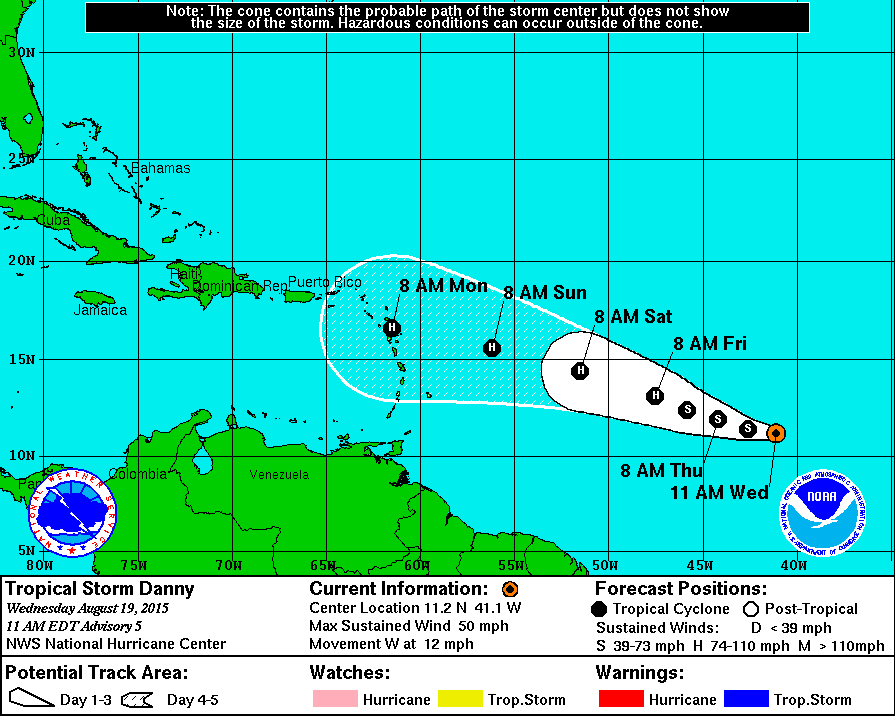
It remains to be seen if this survives beyond five days, and confidence in the forecast is low. Odds are fairly high this gains latitude and recurves into the Atlantic if it hangs on, but this idea could change. Again, see the afternoon Weather Xtreme video for all the maps and graphics.
WEATHER BRAINS: Don’t forget you can listen to our weekly 90 minute netcast anytime on the web, or on iTunes. This is the show all about weather featuring many familiar voices, including our meteorologists here at ABC 33/40.
CONNECT: You can find me on all of the major social networks…
Facebook
Twitter
Google Plus
Instagram
Look for the next Weather Xtreme video here by 7:00 a.m. tomorrow…
Category: Alabama's Weather
About the Author (Author Profile)
James Spann is one of the most recognized and trusted television meteorologists in the industry. He holds the AMS CCM designation and television seals from the AMS and NWA. He is a past winner of the Broadcast Meteorologist of the Year from both professional organizations.Subscribe
If you enjoyed this article, subscribe to receive more just like it.


