

Showers/Storms Developing Again
RADAR CHECK: As expected, scattered to numerous showers and storms have formed across North/Central Alabama in the moist airmass this afternoon… they are moving east.
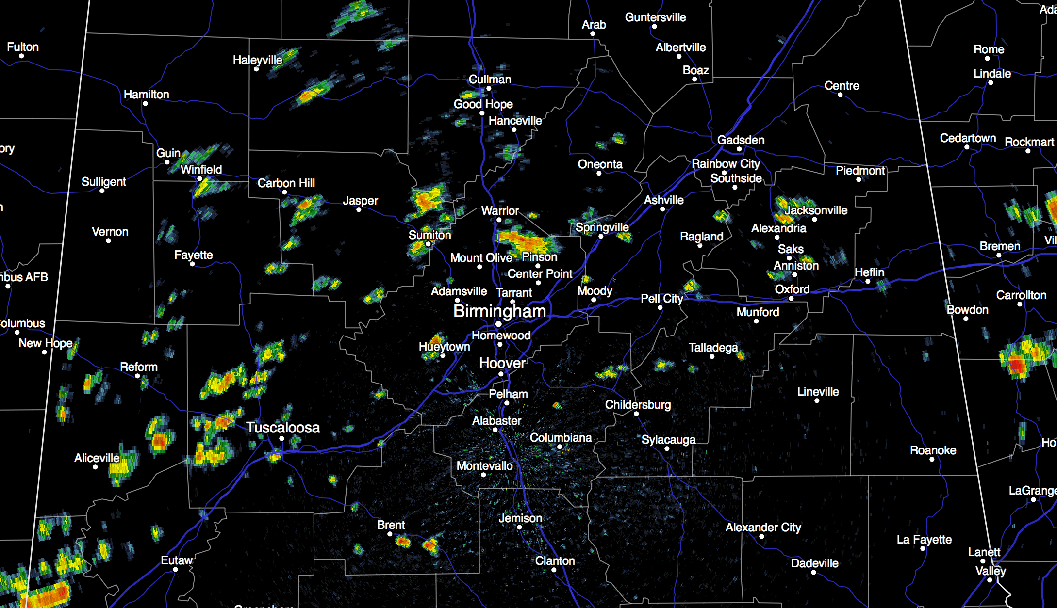
Showers and storms will taper off this evening once the sun goes down and the atmosphere becomes more stable.
TOMORROW AND THE WEEKEND: A surface front will be nearly stationary tomorrow over far North Alabama; places like Birmingham, Tuscaloosa, Anniston, and Gadsden will remain in moist air, so we will maintain the risk of scattered showers and thunderstorms with a mix of sun and clouds. The high tomorrow should be in the mid 80s, and it should be the 6th consecutive day with a high under 90 degrees for most communities around here.
The front to the north will slowly lose it’s identity over the weekend, and for now it looks like we will have a partly sunny sky Saturday and Sunday, and we will need to mention the chance of “scattered, mostly afternoon and evening showers and thunderstorms”. Not as widespread as recent days, however… the chance of any one spot getting wet both days will be about one in three. Highs for the weekend will be close to 90 degrees.
NEXT WEEK: A “cold front” will pass through Monday, with some risk of a brief shower or storm… then we get into dry, continental air for Tuesday, Wednesday, and possibly Thursday. Expect lower humidity on these three days, with cooler nights. Highs will be in the 80s, and we will drop down into the low 60s early Wednesday… cooler spots should visit the 50s for a nice preview of fall.
HIGH SCHOOL FOOTBALL WEATHER: While we can’t rule out a few showers during the high school games tonight, a majority of the showers and storms should be over by kickoff at 7:00 p.m. Temperatures will fall from the low 80s into the upper 70s. Then, for games tomorrow night, pretty much the same situation. Evening showers and storms should be mostly over by 7:00 p.m.. with only an outside risk of a brief shower during the game. Kickoff temperatures tomorrow evening will be in the low 80s, with 70s by the second half.
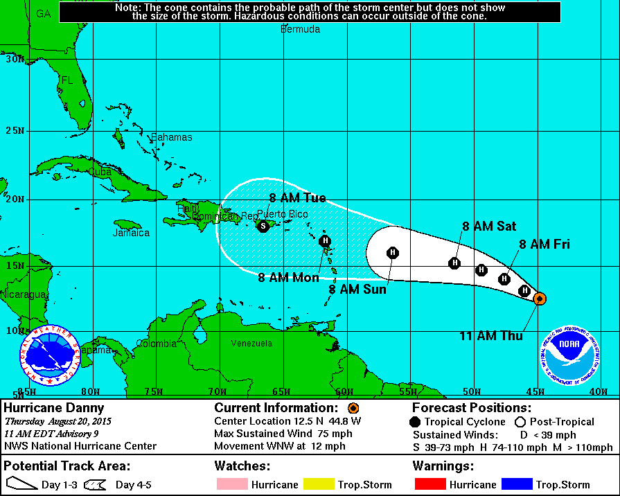
DANNY: The system was upgraded to a category one hurricane this morning with sustained winds of 75 mph…
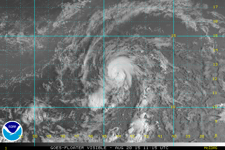
Danny is expected to remain a minimal hurricane through the weekend, but it will begin to weaken early next week as it encounters shear over the northern Caribbean. Many of the global models weaken the system into an open wave before it reaches Hispaniola… but it is still very early and we will keep an eye on it.
We should note there is another disturbance in the Atlantic well to the east of the Florida coast… this one could develop into a sub-tropical type storm in coming days, but most likely it stays offshore and will move away from the U.S. East Coast. See the Weather Xtreme video for maps, graphics, and more details.
GULF COAST WEATHER: We expect about 6 to 8 hours of sunshine on the coast from Gulf Shores west to Panama City Beach through the weekend, with a passing storm from time to time. Highs will remain in the upper 80s on the coast, with low 90s inland. Sea water temperatures remain in the mid 80s.
See the complete Gulf Coast 7 Day Planner here. The Gulf Coast Beach Forecast is presented by Gulf Shores Plantation by Mandoki Hospitality Vacation Rentals. Escape to Gulf Shores Plantation where memories last a lifetime.
WEATHER BRAINS: Don’t forget you can listen to our weekly 90 minute netcast anytime on the web, or on iTunes. This is the show all about weather featuring many familiar voices, including our meteorologists here at ABC 33/40.
CONNECT: You can find me on all of the major social networks…
Facebook
Twitter
Google Plus
Instagram
NEED HELP WITH YOUR WEATHER RADIO? Before you know it, the fall tornado season will be here. And, this evening we kick off our annual “weather radio programming tour”. If you need your NOAA Weather Radio programmed or checked, have questions, or need help, come see us. We will be at Martin’s Pharmacy in Oxford, on Quintard across from the mall from 3:30 until 6:30 p.m.
Look for the next Weather Xtreme video here by 7:00 a.m. tomorrow…
Category: Alabama's Weather
About the Author (Author Profile)
James Spann is one of the most recognized and trusted television meteorologists in the industry. He holds the AMS CCM designation and television seals from the AMS and NWA. He is a past winner of the Broadcast Meteorologist of the Year from both professional organizations.Subscribe
If you enjoyed this article, subscribe to receive more just like it.


