

Scattered Afternoon Storms
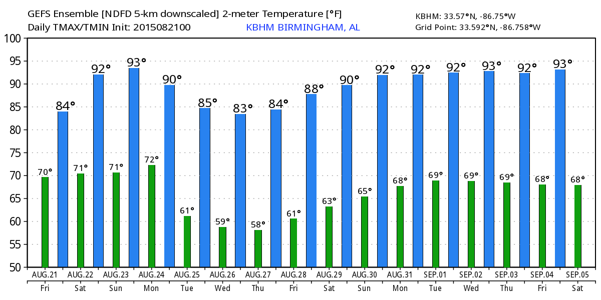
ON THE MAPS: A surface front is stalled near the Alabama/Tennessee border this morning; much of the state remains in a very moist airmass with precipitable water values of around 2 inches. This means we will deal with scattered showers and storms again, mostly this afternoon and early tonight. Like yesterday, the stronger storms will produce heavy rain and frequent lightning, but they should generally remain below severe limits. Otherwise, expect a mix of sun and clouds today with a high in the mid to upper 80s. Today will be the 6th consecutive day with a high below 90 degrees for most communities around here.
HIGH SCHOOL FOOTBALL TONIGHT: While many of the showers/storms will end by kickoff time at 7:00, a few could linger, so to be perfectly safe you might want to take the rain gear. Temperatures will be in the low 80s at kickoff, with upper 70s by the final whistle.
THE WEEKEND: Not much change; there will be sufficient moisture for “scattered, mostly afternoon and evening showers and thunderstorms” both days, although they should be fewer in number Sunday. There will be some very nice intervals of sun along the way, with a high in the upper 80s tomorrow, and low 90s Sunday.
NEXT WEEK: A front passes through Monday with some risk of a passing shower or storm, then we get into dry continental air Tuesday through Thursday with lower humidity and cooler nights. Many North Alabama communities could very well reach the 50s early Wednesday and Thursday morning for a nice taste of fall. See the Weather Xtreme video for maps, graphics, and more details.
AT THE BEACH: About 6 to 8 hours of sunshine daily through early next week on the Gulf Coast from Gulf Shores west to Panama City Beach with a passing thunderstorm from time to time. Highs on the immediate coast will be in the upper 80s, with low 90s inland. The sea water temperature early this morning at the Dauphin Island Sea Lab is 86 degrees.
See the complete Gulf Coast 7 Day Planner here. The Gulf Coast Beach Forecast is presented by Gulf Shores Plantation by Mandoki Hospitality Vacation Rentals. Escape to Gulf Shores Plantation where memories last a lifetime.
DANNY: This is a very small hurricane with sustained winds of 85 mph in the central Atlantic. It is expected to weaken in coming days, and it should be a tropical storm as it moves into the far northern Leeward Islands Monday. Many global models weaken the system into an open tropical wave beyond that due to shear and dry air; a good chance it will bring beneficial rain to Puerto Rico without too much wind by Tuesday.
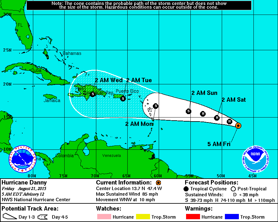
It is doubtful that Danny survives west of Hispaniola… but we all know tropical systems can bring surprises, so we will still watch it closely.
REST OF THE TROPICS: A disturbance in the Atlantic well east of Florida has a chance to become Tropical Storm Erika over the weekend; that will most likely stay offshore well east of the U.S. Atlantic Coast. And, another tropical wave is emerging off the coast of Africa with some chance of slow development in coming days. Again, see the Weather Xtreme video for all the graphics and additional details.
WEATHER BRAINS: Don’t forget you can listen to our weekly 90 minute netcast anytime on the web, or on iTunes. This is the show all about weather featuring many familiar voices, including our meteorologists here at ABC 33/40.
CONNECT: You can find me on all of the major social networks…
Facebook
Twitter
Google Plus
Instagram
Look for the next Weather Xtreme video here by 4:00 this afternoon… enjoy the day!
Category: Alabama's Weather
About the Author (Author Profile)
James Spann is one of the most recognized and trusted television meteorologists in the industry. He holds the AMS CCM designation and television seals from the AMS and NWA. He is a past winner of the Broadcast Meteorologist of the Year from both professional organizations.Subscribe
If you enjoyed this article, subscribe to receive more just like it.


