

One Rain Band Exiting
But here comes another one.
The area of rain that moved through North Alabama early this morning – rattling some people out of bed with some loud thunder – has moved eastward into Georgia just before 9:00 am. But a new batch of storms with rain, thunder, and lightning has entered Northwest Alabama and will be traversing the northern half of the state for the next several hours.
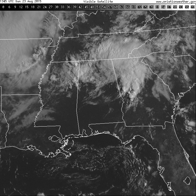
As you can see from the visible satellite image centered on Montgomery, AL, there is the thick area of clouds over the northern half of Georgia. The clouds thin out a bit between that batch of clouds and the next batch coming into Northwest Alabama giving Central Alabama a touch of sunshine, though I note that temperatures have not gone up much. Temperatures in the second round of storms were sticking pretty close to the 70 to 75 degree range. I had a little sun at my house but the temperature only went up about 3 degrees.
The temperature forecast for Alabama locations today is going to be a trifle tricky! Areas that are getting the both rounds of storms this morning may not get out of the 70s while across South Alabama where there have been very few showers that area is likely to see highs into the upper 80s and lower 90s.
Rain-wise I recorded 43 hundredths of an inch in the first batch of storms just before sunrise. So far no additional rain in the bucket as some of the leading edge of rain area has been dissipating as it rolls into Jefferson County.
-Brian-
Category: Alabama's Weather
About the Author (Author Profile)
Brian Peters is one of the television meteorologists at ABC3340 in Birmingham and a retired NWS Warning Coordination Meteorologist. He handles the weekend Weather Xtreme Videos and forecast discussion and is the Webmaster for the popular WeatherBrains podcast.Subscribe
If you enjoyed this article, subscribe to receive more just like it.


