

Cooler, Drier Air Arrives Tonight
ON THE MAPS: At mid-afternoon a cold front is lined up from near Athens to Vernon… you can pick it out by the northern edge of the cumulus field across Alabama…
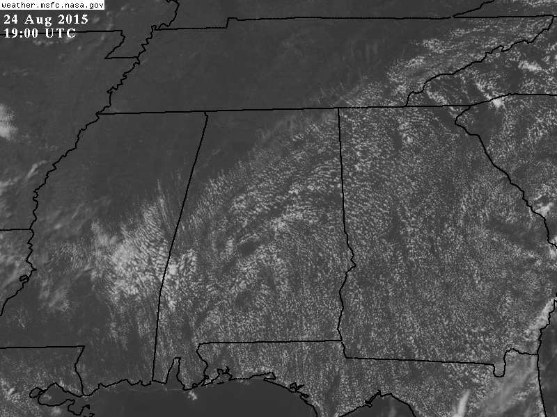
A few scattered storms have formed ahead of the front, best chance of them this evening will be over the southern half of the state. Temperatures are mostly in the 80s; today is the ninth consecutive day with a high below 90 for Birmingham.
REST OF THE WEEK: Some delightful weather for our state thanks to dry, continental air moving in from the north. We project sunny days, lower humidity levels, and cooler nights; highs will be mostly in the mid 80s, with lows in the 57-62 degree range most mornings through Thursday. Cooler pockets could very well see low to mid 50s early Wednesday for a very nice fall preview.
Friday will be another mostly sunny day with a high in the upper 80s.
THE ALABAMA WEEKEND: Moisture from the Atlantic will cover Georgia and South Carolina, but for most of the state we believe Saturday will be dry with a partly sunny sky and a high in the upper 80s. A few showers could show up Saturday afternoon over far East Alabama around U.S. 431.
Then, Sunday, the latest run of the GFS pushes the moisture into our state from the east, and we will need to introduce the risk of scattered showers, but not an “all day” kind of rain. The high Sunday afternoon will be in the mid to upper 80s.
NEXT WEEK: Looks like afternoon highs will be close to 90, with some risk of scattered showers during the first half of the week. See the Weather Xtreme video for maps, graphics, and more details.
GULF COAST WEATHER: Looks very nice through the week with mostly sunny days, fair nights, and only widely scattered thunderstorms. Highs will be in the 80s, and sea water temperatures are mostly in the mid 80s. See the complete Gulf Coast 7 Day Planner here. The Gulf Coast Beach Forecast is presented by Gulf Shores Plantation by Mandoki Hospitality Vacation Rentals. Escape to Gulf Shores Plantation where memories last a lifetime.
TROPICS: Danny dissipated near the Leeward Islands this morning, but a few wave in the Central Atlantic, about halfway between the coast of Africa and the Lesser Antilles, will become a tropical depression at any time. Good chance this will be Tropical Storm Erika within 48 hours; for now long range model guidance suggests a recurvature path off the U.S. East Coast is the most likely scenario, but this could change.
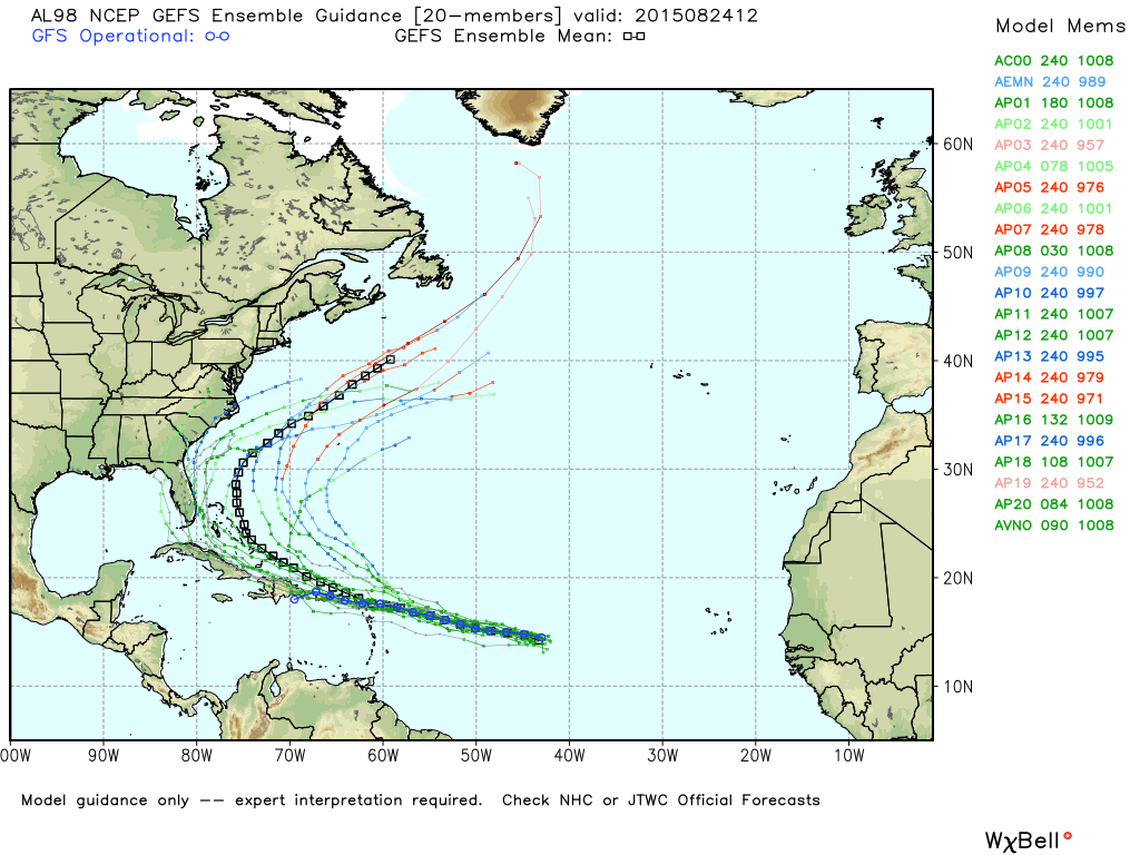
Another wave over the far eastern Atlantic is not expected to strengthen anytime soon.
WEATHER BRAINS: Don’t forget you can listen to our weekly 90 minute netcast anytime on the web, or on iTunes. This is the show all about weather featuring many familiar voices, including our meteorologists here at ABC 33/40. Tonight we produce show number 500… you can watch at 8:30 CT on “James Spann 24/7” on cable systems around the state, or on the web here.
CONNECT: You can find me on all of the major social networks…
Facebook
Twitter
Google Plus
Instagram
Look for the next Weather Xtreme video here by 7:00 a.m. tomorrow…
Category: Alabama's Weather
About the Author (Author Profile)
James Spann is one of the most recognized and trusted television meteorologists in the industry. He holds the AMS CCM designation and television seals from the AMS and NWA. He is a past winner of the Broadcast Meteorologist of the Year from both professional organizations.Subscribe
If you enjoyed this article, subscribe to receive more just like it.


