

Nice Touch Of Fall
COOL AUGUST MORNING: Temperatures have dropped into the 50s over the northern third of Alabama early this morning…
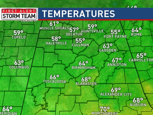
Today promises to be a delightful day for August, with a good supply of sunshine, lower humidity, and below average temperatures. Most communities will see a high in the mid 80s today, places around the Tennessee border might hold in the 70s all day despite a sunny sky.
TONIGHT: It will be the coolest night of the week, we project upper 50s as far south as Birmingham, and some of the cooler pockets across North Alabama could see low to mid 50s. Birmingham’s record low for August 26 is 55 degrees set in 1966… we probably won’t break that, but we will be close.
REST OF THE WEEK: We stay dry tomorrow through Friday, with sunny days, and clear pleasant nights. Dry air means no afternoon showers; highs will be in the mid 80s tomorrow and Thursday, upper 80s Friday.
THE ALABAMA WEEKEND: Moisture will begin to creep into the state from the east. While most of Alabama will be dry Saturday, we will mention some risk of a shower near the Georgia border. Then, on Sunday, there will be some risk of scattered showers statewide with a few cloudy periods. Highs over the weekend will be in the 87 to 90 degree range.
Birmingham has now gone 9 consecutive days with a high below 90 degrees, and that streak continues at least through Friday.
NEXT WEEK: A few scattered, mostly afternoon showers are possible early in the week, with a high close to 90 degrees as we begin meteorological fall Tuesday. See the Weather Xtreme video for maps, graphics, and more details.
AT THE BEACH: Mostly sunny days, fair nights through the weekend with only isolated storms around from Panama City Beach west to Gulf Shores. Highs in the upper 80s, sea water temperatures in the mid 80s. See the complete Gulf Coast 7 Day Planner here. The Gulf Coast Beach Forecast is presented by Gulf Shores Plantation by Mandoki Hospitality Vacation Rentals. Escape to Gulf Shores Plantation where memories last a lifetime.
ERIKA IS ON THE BOARD: Tropical Storm Erika will move west/northwest in coming days, with the chance of the system becoming a category one hurricane by the time it reaches the Southeast Bahamas this weekend.
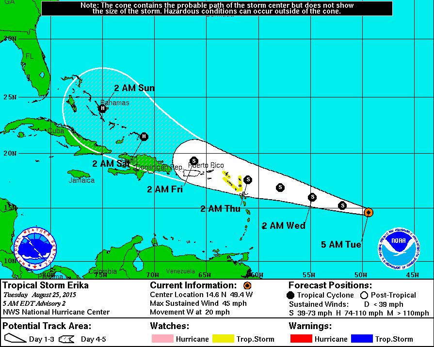
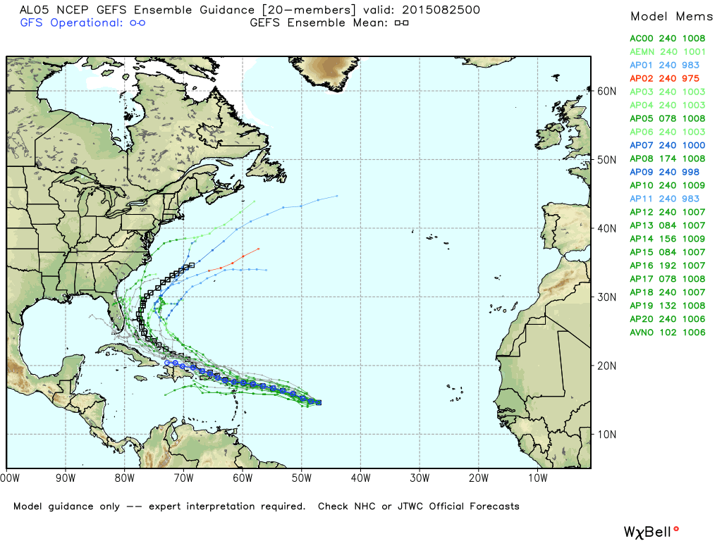
Long range ensemble guidance suggests the most likely scenario is that Erika recurves just off the East Coast of the U.S…. but understand that is not a lock at this stage of the game.
One way or another this doesn’t look like a Gulf of Mexico system. The rest of the Atlantic basin is pretty quiet; a weak wave near the Cape Verde Islands is not expected to develop.
WEATHER BRAINS: Don’t forget you can listen to our weekly 90 minute netcast anytime on the web, or on iTunes. This is the show all about weather featuring many familiar voices, including our meteorologists here at ABC 33/40. We produced show number 500 last night… scroll down for the show notes.
CONNECT: You can find me on all of the major social networks…
Facebook
Twitter
Google Plus
Instagram
I will be speaking today in Walker County at Cordova Health and Rehabilitation… look for the next Weather Xtreme video here by 4:00 this afternoon. Enjoy the day!
Category: Alabama's Weather
About the Author (Author Profile)
James Spann is one of the most recognized and trusted television meteorologists in the industry. He holds the AMS CCM designation and television seals from the AMS and NWA. He is a past winner of the Broadcast Meteorologist of the Year from both professional organizations.Subscribe
If you enjoyed this article, subscribe to receive more just like it.


