

Cool Summer Night Ahead
FALL PREVIEW: What a delightful day; this is as nice as it gets in August in Alabama. Blue sky, sunshine, low humidity, and excellent visibility. Temperatures are in the low to mid 80s, and not a single shower in the entire state.
Photo below is from @objectivityrach, taken this afternoon in downtown Birmingham.

Many communities will drop into the 50s early tomorrow for a very nice taste of fall; Birmingham’s record low for August 26 is 55 set in 1966… we will probably miss it be a couple of degrees.
REST OF THE WEEK: We stay dry through Friday, with sunny days and clear pleasant nights. Highs hold in the mid 80s tomorrow and Thursday, followed by upper 80s Friday. Humidity levels will also begin to creep up by the end of the week; we all know that “sticky” feeling will be back.
THE ALABAMA WEEKEND: Most of the state should stay dry Saturday, although a few showers could show up near the Georgia border, over the far eastern side of the state, where moisture levels will rise. Then, there will be risk of scattered showers statewide Sunday with a mix of sun and clouds. Highs over the weekend will be in the 87 to 90 degree range.
Today is the 10th consecutive day with a high under 90 degrees for Birmingham… will be interesting to see if we can finally rise back to 90 at some point over the weekend.
NEXT WEEK: Some risk of widely scattered showers during the first half of the week, otherwise partly sunny days with a high close to 90; see the Weather Xtreme video for maps, graphics, and more details.
AT THE BEACH: Mostly sunny days and fair nights with only isolated showers from Panama City Beach west to Gulf Shores through the weekend. Highs in the upper 80s on the coast, with sea water temperatures in the mid 80s. See the complete Gulf Coast 7 Day Planner here. The Gulf Coast Beach Forecast is presented by Gulf Shores Plantation by Mandoki Hospitality Vacation Rentals. Escape to Gulf Shores Plantation where memories last a lifetime.
TOPIC: TROPICS: Tropical Storm Erika is packing sustained winds of 45 mph, and will be near the northern Leeward Islands Thursday. A decent chance this becomes a hurricane over the Bahamas early next week; it remains to be seen if this will impact the U.S. Atlantic Coast. Just too early to call for now.
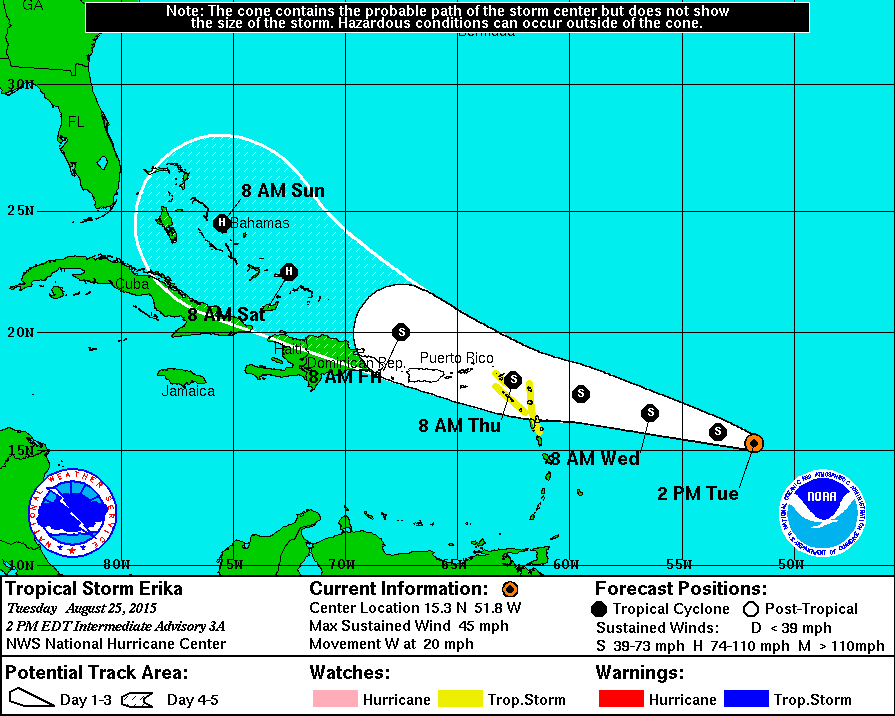
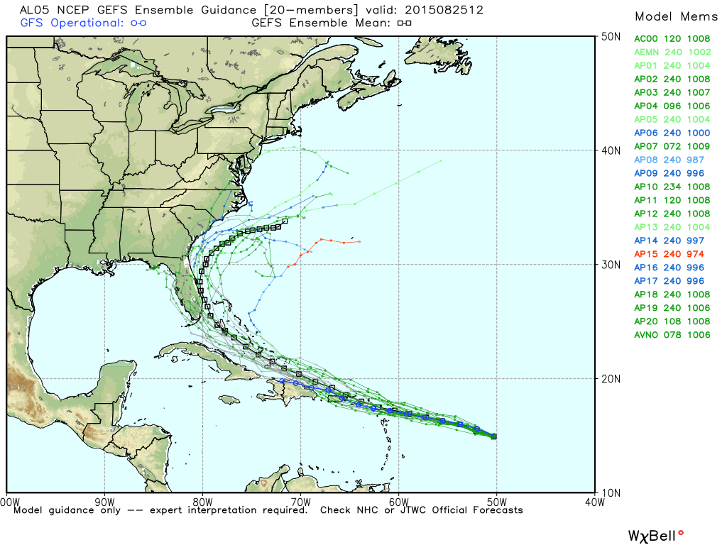
For now odds are low that this will be a Gulf of Mexico storm.
Elsewhere, a tropical wave will emerge off the coast of Africa tomorrow, and some slow development is possible over the next few days.
WEATHER BRAINS: Don’t forget you can listen to our weekly 90 minute netcast anytime on the web, or on iTunes. This is the show all about weather featuring many familiar voices, including our meteorologists here at ABC 33/40.
CONNECT: You can find me on all of the major social networks…
Facebook
Twitter
Google Plus
Instagram
Look for the next Weather Xtreme video here by 7:00 a.m. tomorrow…
Category: Alabama's Weather
About the Author (Author Profile)
James Spann is one of the most recognized and trusted television meteorologists in the industry. He holds the AMS CCM designation and television seals from the AMS and NWA. He is a past winner of the Broadcast Meteorologist of the Year from both professional organizations.Subscribe
If you enjoyed this article, subscribe to receive more just like it.


