

Scattered Showers/Storms Return
**No afternoon Weather Xtreme video today due to travel**
RADAR CHECK: A few small, isolated showers have formed this afternoon, mostly south and east of Birmingham.
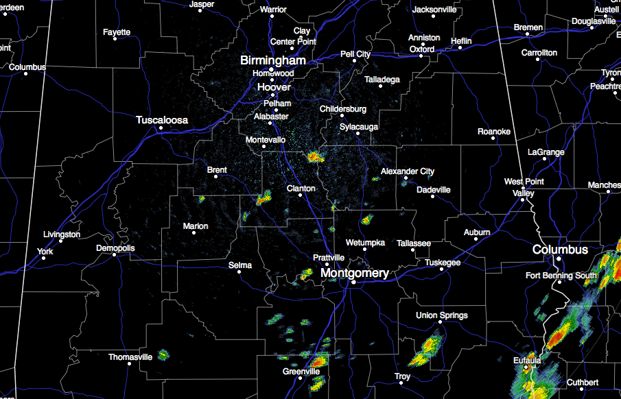
These showers will end soon after sunset, and most high school football stadiums won’t have any rain issues tonight.
Birmingham reports 86 degrees at 2:00… looks like today will be the 13th consecutive day with a high under 90 degrees.
THE WEEKEND: Moisture levels will deepen, and we will mention scattered showers and thunderstorms tomorrow and Sunday with a mix of sun and clouds both days. While most of the showers will come during the afternoon and evening hours, we can’t rule out a late night or morning shower or two. Highs over the weekend will be mostly in the mid 80s.
NEXT WEEK: We expect only widely scattered showers Monday through Wednesday with partly sunny days and highs between 87 and 90 degrees. The 12Z GFS hints that showers and storms could become more numerous by Thursday and Friday with deeper moisture.
ERIKA: The tropical storm, just south of Hispaniola, remains very disorganized this afternoon.
With continued wind shear, and interaction with the mountainous island, there is a very real chance that Erika won’t survive the next 12 hours.
If it does hang on, the ultimate track will be determined by it’s strength. If the system can get it’s act together and become better organized, it should turn northward into the Florida Peninsula by Monday, staying below hurricane strength (which is the official NHC track).
If the system remains a closed low, but stays weak and disorganized, the low level swirl will move into the Gulf of Mexico. There, the system will encounter 30 to 40 knots of deep layer shear, meaning it will most likely dissipate without bothering anyone.
One way or another this, most likely, won’t be an issue for Alabama. Here is the latest NHC track.
We will keep an close eye on it over the weekend, of course.
GULF COAST WEATHER: We are projecting about 6 to 8 hours of sunshine each day from Panama City Beach to Gulf Shores through early next week with a few scattered storms possible; highs on the coast will be in the upper 80s, with sea water temperatures in the mid 80s.
A little early for a specific Labor Day weekend forecast, but for now we don’t see anything to suggest high rain coverage. No signs of any tropical issues.
See the complete Gulf Coast 7 Day Planner here. The Gulf Coast Beach Forecast is presented by Gulf Shores Plantation by Mandoki Hospitality Vacation Rentals. Escape to Gulf Shores Plantation where memories last a lifetime.
WEATHER BRAINS: Don’t forget you can listen to our weekly 90 minute netcast anytime on the web, or on iTunes. This is the show all about weather featuring many familiar voices, including our meteorologists here at ABC 33/40.
CONNECT: You can find me on all of the major social networks…
Facebook
Twitter
Google Plus
Instagram
Brian Peters will have the video updates tomorrow and Sunday… my next Weather Xtreme video will be posted here bright and early Monday morning by 7:00. Enjoy the weekend!
Category: Alabama's Weather
About the Author (Author Profile)
James Spann is one of the most recognized and trusted television meteorologists in the industry. He holds the AMS CCM designation and television seals from the AMS and NWA. He is a past winner of the Broadcast Meteorologist of the Year from both professional organizations.Subscribe
If you enjoyed this article, subscribe to receive more just like it.


