

Showers Likely
Let me start off by stating that my confidence in this forecast is not particularly good! Why, you may ask? Well, we’ve got a tropical storm that the models have not been handling well in either intensity or track. Add to that the presence of a weak upper low spinning in the vicinity of Mobile, and you come up with a low confidence factor considering the weak intensity of all of these features. But, we dive into what we’ve got knowing that we’ll probably have to make adjustments down the road – but that’s the nature of meteorology!
A weak upper low was situated above Mobile early this morning, and that weak upper low will be spinning for the next several days as it meanders around the northern Gulf coast and the Lower Mississippi River Valley. It should provide enough lift over Central Alabama to make showers and thunderstorms likely this afternoon and evening. Showers were few and far between this morning, but as the day wears on, I think we’ll see showers become more numerous with increased coverage. Temperatures should stay down somewhat because of the presence of clouds and showers with highs in the middle 80s.
Storm Prediction Center (SPC) is not forecasting any areas of severe weather today with only marginal areas in parts of South and Southwest Florida because of the presence of Erika – or what may be left of Erika.
If you have plans to head to the beaches of Southwest Alabama and Northwest Florida you will have to contend with daily shower chances for the week ahead. Temperatures along the beach from Dauphin Island to Apalachicola will be mainly in the upper 80s with morning lows in the middle 70s. Sea water temperature was running in the lower 80s with 85 being reported at Dauphin Island.
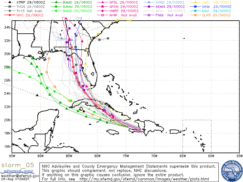
Then there’s Erika. Erika continues to defy forecasters as it moves nearly due west overnight. Erika remained disorganized as it continued to fight a hostile environment with substantial wind shear as well as the problems associated with moving over the rugged terrain of Hispaniola. The present projected track also means that Erika will have to deal with continued interaction with land as it basically moves northwestward right along Cuba. Erika is not presenting much of a wind or surge threat, fortunately, however, Erika presents a big threat in the heavy rainfall it will produce which may trigger landslides in Hispaniola and Cuba. If you can, read the forecast discussion from NHC which is peppered with words like “low confidence” and “difficult to locate.” NHC also did not issue any kind of watch or warning for Florida because of the tremendous uncertainty in the forecast of Erika, but I do expect to see some type of watch or advisory issued later today. Hopefully, an Air Force Reserve Hurricane Hunter aircraft will be investigating Erika later this morning and that data will help provide a clearer picture of Erika’s physical condition.
Getting back to the GFS and Central Alabama, moisture levels drop somewhat as seen by precipitable water charts, so the level and coverage of showers should drop back after today and Sunday. It will be difficult if not downright improbable to be able to pick which days have the best chances of rain. The weak upper low will meander around the Lower Mississippi Valley for much of the week ahead plus we’ll have to contend with Erika, where it goes and just how strong it will be. So the forecast for much of the week ahead will include a mention of showers as a possibility nearly every day.
The good news from this scenario is that temperatures should stay mainly in the 80s. We could hit 90 or 91 again but that will depend on just how much cloud cover we have and how many showers develop in the heat of the afternoon.
The forecast uncertainty is not limited to the GFS guidance either. I browsed through a little of the ECMWF output and found that it, too, was having trouble discerning a track for Erika.
I’ll be keeping a close eye on our weather today, so you can check back here for later updates on what the weather holds for us. The next Weather Xtreme Video will be posted here on Sunday morning. Have a great day and Godspeed.
-Brian-
Category: Alabama's Weather
About the Author (Author Profile)
Brian Peters is one of the television meteorologists at ABC3340 in Birmingham and a retired NWS Warning Coordination Meteorologist. He handles the weekend Weather Xtreme Videos and forecast discussion and is the Webmaster for the popular WeatherBrains podcast.Subscribe
If you enjoyed this article, subscribe to receive more just like it.


