

Friday Night Lights Weather Focus
UPDATED 830 PM
There are nearly 200 high school football games going on across Alabama tonight and many of them across Central Alabama have been impacted by lightning delays and rain.
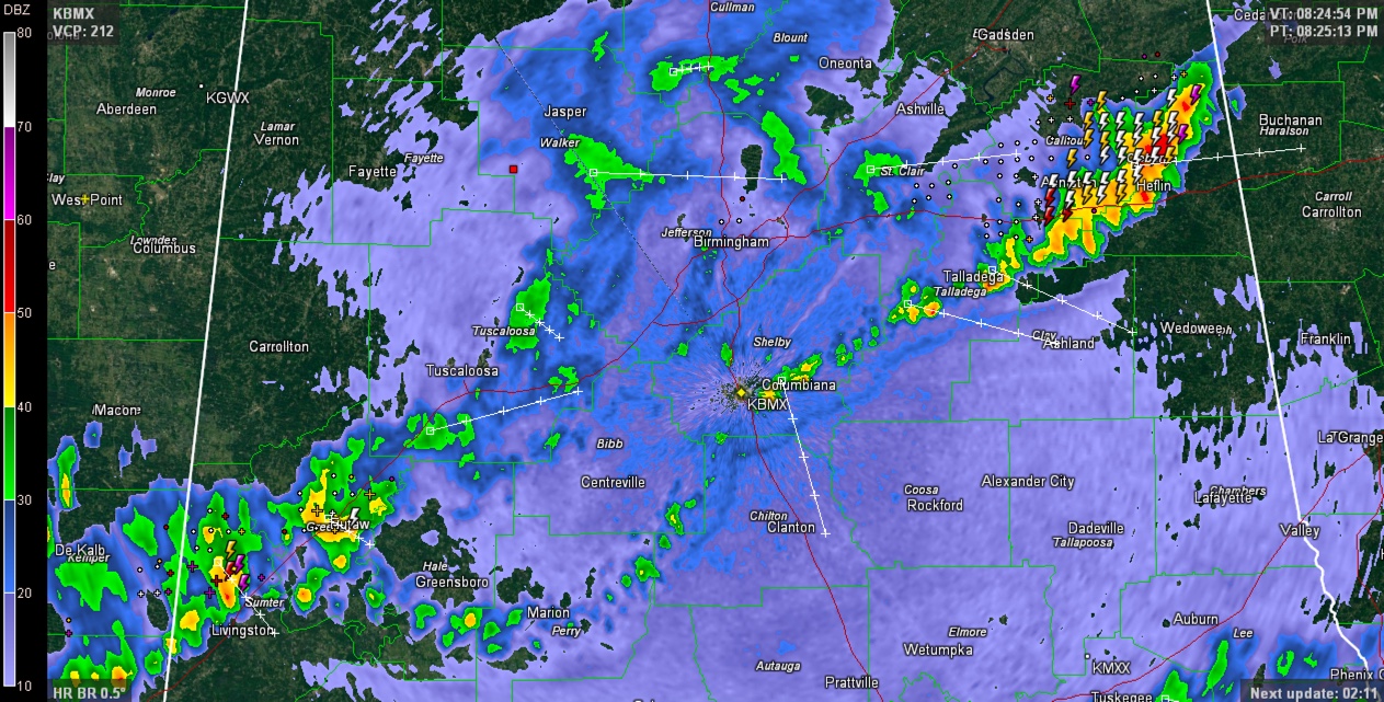
The lightning threat is now over for areas north of I-59 tonight. Rain does cover a large part of Tuscaloosa, Walker, Jefferson and St. Clair Counties however.
Storms are strongest over West Alabama’s Greene and Hale Counties and over East Alabama from Talladega through Anniston and Oxford to Heflin to south of Piedmont.
ONLY LIGHTNING THREATS LEFT
In East Alabama, are over Calhoun and Cleburne Counties, where there is copious dangerous lightning.
In West Alabama, the threat is now limited to Sumter and Greene Counties. This activity will push across much of Perry county.
PREVIOUS UPDATE
Marion, Lamar, Fayette and Winston Counties
Rain is mostly over and the threat of lightning is gone.
Cullman, Walker and Tuscaloosa Counties
Rain covers much of these counties at 8 p.m. The lightning threat is going downhill now, with only a few strikes over the past 20 minutes.
Blount County
The activity over Walker and Cullman Counties will overspread much of Blount County over the next hour with a few isolated lightting strikes.
Jefferson County
A storm has flared over Tarrant at 758 p.m. It will bring lightning to Northeast Birmingham over the next 30 minutes. Otherwise, storms have pushed south of I-459 now, mostly into northern Shelby County. Except for the leftover lightning over northeastern and eastern parts of the county, the lightning threat has diminished and suspended games can generally be restarted.
Shelby County
Rain and storms will reach northwestern Shelby County around 7 p.m., reaching Chelsea, Columbiana and Calera around 715-730 p.m. It will take about 25-30 minutes for the main activity to go through and rain and isolated lightning will continue through about 9-930 p.m.
Tuscaloosa/Pickens Counties
The heaviest storms are over extreme southern Pickens and Tuscaloosa Counties at 730 p.m. But rain and isolated lightning still is occurring across much of Tuscaloosa County. There have been recent strikes around Coker and Elrod, but the activity is diminishing.
It will reach the Tuscaloosa area starting around 620-630 pm. Eastern parts of Tuscaloosa county will see the activity starting after 630 p.m. Some of the heaviest rain and lightning will affect Tuscaloosa County. Winds will gust to 40 mph. The main activity will last about 45 minutes, with rain and isolated lightning continuing
Greene County/Hale Counties
Some of the strongest storms are over northern Greene County and will push into Hale County. The strongest storms extend frmo Eutaw to Moundville at 730 p.m. They are spreading south and will end from the north between 8-9 p.m.
Hale/Bibb Counties
Rain and storms will begin affecting northern Hale County as early as 645 p.m and Bibb County by 7 p.m. The main activity will last around 30-45 minutes with additional moderate rain and isolated lightning strikes occurring until around 8-830 p.m.
St. Clair/Talladega/Calhoun/Cleburne Counties
Very heavy thunderstorms have exploded along I-20 from Birmingham to Lincoln. They will produce frequent deadly lightning and very heavy rain for the next 45 minutes in areas that are experiencing them.
EAST ALABAMA
Cherokee County
Storms are already starting to affect extreme northern Cherokee County at 6 p.m. Stronger storms will arrive across northern Cherokee County around 630-645 p.m. lasting 30 minutes or so. The Centre area will see this activity. Additional showers and storms will affect the county between 7-8 p.m.
Clay/Randolph Counties
Showers and storms will begin affecting western sections of these two counties around 745 p.m., reaching Ashland around 815 and Wedowee around 830 pm.
Chilton County
The heavier storms over Tuscaloosa County will begin affecting Chilton County as early as 730 p.m., with a good 30-45 minutes of heavy rain and lightning. Rain and lightning will continue through around 830 p.m. in Jemison and 9 p.m. in Maplesville and Clanton.
Coosa/Tallapoosa/Chambers Counties
Storms arrive in Rockford around 8 p.m., Alex City around 815 p.m., Dadeville around 830 and Lafayette around 9 p.m.
Category: Alabama's Weather
About the Author (Author Profile)
Bill Murray is the President of The Weather Factory. He is the site's official weather historian and a weekend forecaster. He also anchors the site's severe weather coverage. Bill Murray is the proud holder of National Weather Association Digital Seal #0001 @wxhistorianSubscribe
If you enjoyed this article, subscribe to receive more just like it.


