

Watching the Gulf
The upper level low that has off the coast of northeastern Florida, Georgia and the Carolinas rotated northwestward to near Columbus, GA yesterday, but not before causing an EF2 near Charleston, South Carolina on Thursday. As it moved to near the Alabama/Georgia line, the large mass of rain that was rotating around the system weakened and fell apart, most likely due to downsloping of the air around the system.
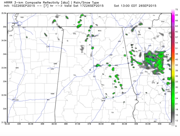
SATURDAY SHOWERS: The broad upper low is centered near Huntsville this morning. A few showers will rotate around the low today, but they should be mainly north of the low. There will be a few scattered showers south of that but the day won’t be a rain out. Highs will be in the upper 70s northeast of US-78/US-280, where clouds will be more cloudy. Southwest of that, there will be a little more sunshine and there will be more in the way of sunshine, allowing the mercury to rise into the lower and middle 80s.
FOOTBALL FORECAST: Alabama will host ULM (University of Louisiana at Monroe) this afternoon at 3:00 at Bryant Denny Stadium; the sky will be mostly cloudy during the game, and a passing shower is possible. Temperatures will fall from near 81 degrees at kickoff, into the mid 70s by the fourth quarter. Mississippi State will visit Auburn at Jordan Hare Stadium tomorrow evening (6:30 kickoff)… the sky will be mostly cloudy with the risk of a shower. Temperature at kickoff near 75 degrees, falling to near 70 by the final whistle.
SUNDAY: Sunday will feature a continued regime of clouds and scattered showers. Highs will be in the lower 80s.
SUPERMOON ECLIPSE: The full moon will be perigee Sunday evening, its closest point in its orbit around the earth. This is the so-called Supermoon. Throw in a total lunar eclipse and you have a perfect lunar storm. But unfortunately, clouds will be thick Sunday night, so this may limit our ability to see it.
TROPICS: Ida is still hanging on in the Central Atlantic, but it should weaken to a tropical disturbance today.
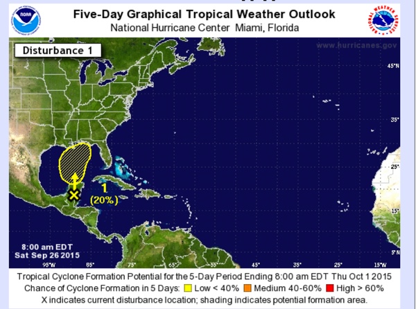
ALL EYES ON THE GULF: A trough of low pressure over the Yucatan Peninsula will move into the southern Gulf of Mexico by Monday. Conditions should be favorable enough for the system to develop into a tropical low as it moves northward. It could become a tropical depresson and a tropical storm is not out of the question, but it should have much of an impact other than rough seas and windy conditions along the coast, especially east of where it makes landfall. And did i say heavy rain? Lots of heavy rain. Also lots of uncertainty about where it might end up. Watch the video for a model madness discussion.
FOR NEXT WEEK: Rain will spread into Alabama late Sunday night and Monday and Tuesday look wet for Central Alabama with periods of showers and thunderstorms. South Alabama could see up to two inches of rain, with higher amounts along the coast. Central Alabama looks like it will see 1-1.5 inches of rain. Expect scattered showers Wednesday and Thursday in the leftover moist airmass. Drying conditions are expected for the weekend.
NEXT BIG RAIN CHANCE: Looks like it will come just after the following weekend with a strong cold front approaching slowly around Monday the 5th with showers and storms.
AT THE BEACH: About 4 to 6 hours of sunshine today and Sunday from Gulf Shores west to Panama City Beach with a few scattered showers or storms, then rain is likely Monday and Tuesday, and that rain could heavy at times with the tropical low lifting northward. Highs will be in the 80s; See the complete Gulf Coast 7 Day Planner here. The Gulf Coast Beach Forecast is presented by Gulf Shores Plantation by Mandoki Hospitality Vacation Rentals. Escape to Gulf Shores Plantation where memories last a lifetime.
WEATHERBRAINS: Next week’s wekely netcast that is all about the weather will feature a preview of the upcoming National Weather Association Annual Meeting in Oklahoma City. Don’t forget you can listen to our weekly 90 minute netcast anytime on the web, or on iTunes. This is the show all about weather featuring many familiar voices, including our meteorologists here at ABC 33/40.
Category: Alabama's Weather
About the Author (Author Profile)
Bill Murray is the President of The Weather Factory. He is the site's official weather historian and a weekend forecaster. He also anchors the site's severe weather coverage. Bill Murray is the proud holder of National Weather Association Digital Seal #0001 @wxhistorianSubscribe
If you enjoyed this article, subscribe to receive more just like it.


