

Saturday Afternoon Forecast Ramblings
Like yesterday, a field of low level cumulus clouds has developed underneath a canopy of high clouds streaming across from the system to the west.
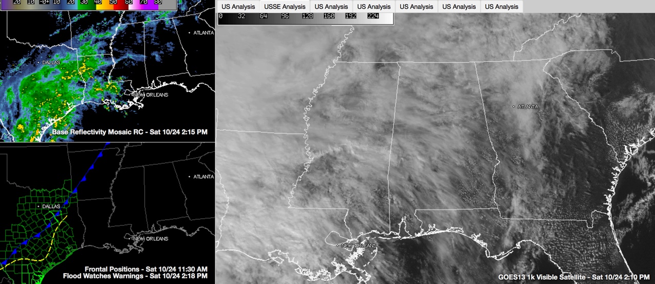
Clouds are thicker over northwestern sections, and the further southeast that you go, the more sun you will find.
Consequently, temperatures are in the middle and upper 70s over northwestern sections, ranging to around 80F in the I-59 corridor and into the lower 80s over South Central sections.
A few light showers has been able to reach the ground over the Tennessee Valley. Huntsville and Decatur have both picked up a trace of precipitation this morning and Muscle Shoals has measured 0.01 inches. Further south, a few light showers and on radar, but most of the precipitation is not reaching the ground. We can’t rule out a light shower at Tuscaloosa for the Alabama/Tennessee game, but significant problems are not anticipated.
Heavy rain covers much of eastern Texas and northwestern Louisiana this afternoon. There are numerous flash flood warnings over Texas and even a tornado warning west of Corpus Christi. This activity is associated with the deep tropical moisture flowing in from the Gulf of Mexico ahead of the remnants of Tropical Depression Patricia, which is over Central Mexico this afternoon.
The low will track to near the Rio Grande by this evening, dissipating as a tropical low. But its energy will help to spin up a non-tropical low on the Lower Texas Coast near Brownsville tonight that will start moving northeast. There will likely be some brief spin up tornadoes this afternoon and through the evening as the old low dissipates and a new low forms.
Meanwhile, Alabama should remain mainly dry through the overnight hours and into the early morning, except for a few showers over the Tennessee Valley. The main shield of rain will push across Louisiana just ahead of the surface low Sunday morning. Rain will start moving into West Alabama late Sunday night and will spread slowly across Central Alabama during the morning.
The low will begin to slow as it runs into a mountain of a high pressure system centered over New England. This huge anticyclone will block the storm’s progress and it will weaken as the upper level support energizing it weakens and dies. The system should have enough oomph left to produce heavy rain across Central Alabama during the day on Monday. We can actually use it, so keep your fingers crossed.
Showers will still be possible on Tuesday as the dying system languishes across the area.
A second trough will be organizing to the northwest and will sweep across the area Tuesday night into Wednesday, pushing a cold front through Alabama. An area of showers and thunderstorms will precede the front.
Today’s 80s may be the last we see for awhile. Expect highs in the middle 70s tomorrow, trending back to the upper 60s to lower 70s Monday through Wednesday with the rain.
Drier and cooler conditions will prevail for the remainder of the week into the weekend, with highs around 70F. Lows will be in the 50s Thursday morning and in the 40s Friday morning.
A few showers will work back into the area by Saturday evening as trick or treaters get ready to head out. Rain won’t be widespread or heavy, but it could dampen things a bit.
Category: Alabama's Weather
About the Author (Author Profile)
Bill Murray is the President of The Weather Factory. He is the site's official weather historian and a weekend forecaster. He also anchors the site's severe weather coverage. Bill Murray is the proud holder of National Weather Association Digital Seal #0001 @wxhistorianSubscribe
If you enjoyed this article, subscribe to receive more just like it.


