

Rain Poised for Central Alabama
Clouds blanket just about all of the Southeast US as a surface low spins across the Northwest Gulf, that low coming out of the remnants of Patricia. Already portions of South and Southeast Texas have seen 10 to 20 inches of rain with significant flooding along with the heavy rainfall. The upper trough over Texas is going to be slow to move eastward today, so while the radar continued to show a massive area of rain to our west, that rain will only gradually move eastward today so rain chances will be highest over the western sections and lowest over the eastern sections.
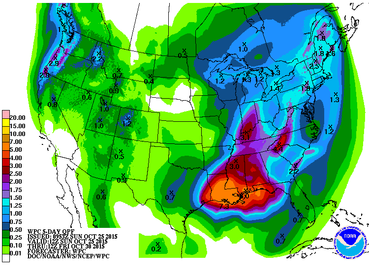
By early Monday, the surface low should move to southern Louisiana spreading rain over just about all of the Southeast US. Rainfall will be heavy at times with the highest amounts over the next five days of 4 to 7 inches along the coast from Lake Charles to Pensacola. Flash flood watches were posted from the extreme western sections of the Florida Panhandle westward to the Houston area – see the graphic. Hopefully, the dry conditions of the last couple of weeks will limit the threat of flash flooding across much of Alabama and Mississippi outside of the coastal areas, but we’ll need to keep an eye on exactly how the rains develop.
In addition to the rain threat, a gale watch for high wind has also been posted for much of the near shore waters of the Central Gulf of Mexico from Houston to Pensacola. Definitely not a good environment for any boating.
Severe weather will be limited to the immediate coastal counties for the next couple of days. As the strength of this system winds down on Tuesday and Wednesday, the severe weather risk will also decrease.
Rain will begin to impact the beaches of Alabama and Northwest Florida this evening as the surface low over Louisiana moves slowly on a north-northeast track. Rain will be heavy through the day and night Monday, with some thunderstorms involved. Rainfall amounts will be heavy, running 3 to 5 inches for areas from the Mississippi coast eastward to Pensacola, with lower amounts east of that with up to 2 to 3 inches from Pensacola to Panama City. By Tuesday, the heavy rain will shift to eastern sections, and eastern sections may see two more inches. Highs will settle back in the 70s for the week ahead, with lows trending through the 60s and into the 50s by next weekend. Water temperatures are hanging tough in the lower and middle 70s. There will be a pretty significant rip current threat, especially from Monday through Wednesday with strong onshore flow. See the complete Gulf Coast 7 Day Planner here. The Gulf Coast Beach Forecast is presented by Gulf Shores Plantation by Mandoki Hospitality Vacation Rentals. Escape to Gulf Shores Plantation where memories last a lifetime.
For those with plans for the races at Talladega today, look for a cloudy sky with only a small chance, about 10 percent, of any rain. Clouds will limit the temperature, so I expect to see highs only climb into the middle 70s. Rain chances will climb quickly for the Talladega area into early Monday morning.
Upper level support for the surface low will diminish into mid-week as the surface low also runs into the large surface high over the eastern US. This will result in the rain area slowly decreasing into mid-week. At the same time, a strong trough will be moving out of western Canada developing a hefty trough over the eastern US by Thursday. This will help to clear out the moisture and dry us out with a couple of fine days for the end of the week and into the weekend. This means our temperatures will drop back nicely with lows in the 40s and highs in the 60s for the end of the week and into the weekend. There should also be some much drier air as dew points fall back with much lowered humidity.
The good weather will continue into at least the first half of the weekend. Another trough coming out of the Southwest US Sunday will bring increased rain chances for the start of next week. Depending on the exact speed of this next system, we might see rain chances by late Sunday.
Looking out into voodoo country, that system should get by us by the middle of week 2. It will be followed by another deep trough around the 5th of November. Just like yesterdays run, this appears to have some potential for severe weather followed by another cool down.
James Spann will be back with the next edition of the Weather Xtreme Video bright and early Monday morning. Check back here often for updates on this developing rain situation. Have a great day and Godspeed.
-Brian-

Category: Alabama's Weather
About the Author (Author Profile)
Brian Peters is one of the television meteorologists at ABC3340 in Birmingham and a retired NWS Warning Coordination Meteorologist. He handles the weekend Weather Xtreme Videos and forecast discussion and is the Webmaster for the popular WeatherBrains podcast.Subscribe
If you enjoyed this article, subscribe to receive more just like it.


