

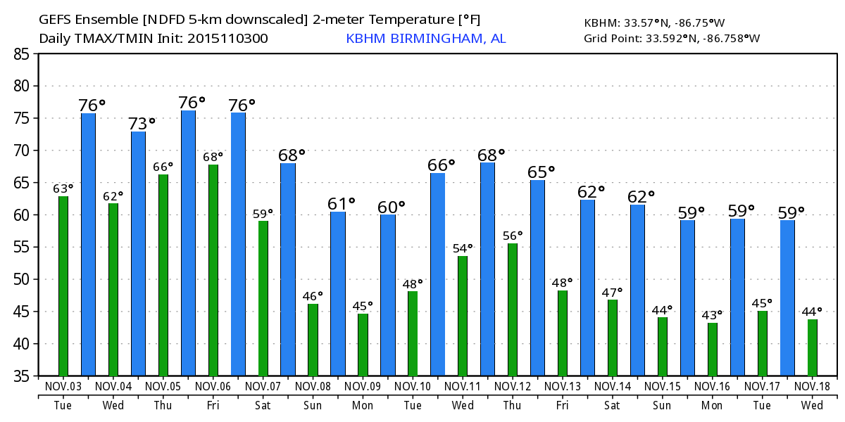
Mild/Muggy November Weather
ON THE MAPS: A cold, long wave upper trough is over the western third of the U.S…. this feature will bring some big mountain snow to the west over the next few days. But, around here, the downstream upper ridge will bring unseasonably mild weather to the Deep South though Friday, with daily highs in the mid to upper 70s. A few spots might even touch 80 degrees on an afternoon or two.
We also have a good pool of low level moisture in place with dew points in the 60s; we are starting this day with low clouds, fog, and a touch of drizzle. The sun breaks through later today, and in the moist air we could see a few widely scattered showers this afternoon after the lunch hour. Chance of any one spot seeing a shower today is only 20 percent due to their scattered nature, and they end once the sun goes down.
TOMORROW/THURSDAY: No real change. Mild, muggy November weather continues with morning clouds, some afternoon sun, and widely scattered, mostly afternoon and evening showers. Afternoon highs will remain in the mid to upper 70s. Maybe an 80 degree high in a few spots. We will be watching developments to the west Thursday; SPC has much of Texas under the standard “slight risk” of severe thunderstorms as the western upper trough begins to lift out.
FRIDAY: Showers and storms will become more numerous late in the day into Friday night as the first part of the upper trough passes north of Alabama. Severe weather doesn’t look likely here with the main dynamic support weakening, and passing well north of us. The weather stays mild and humid with a high well up in the 70s.
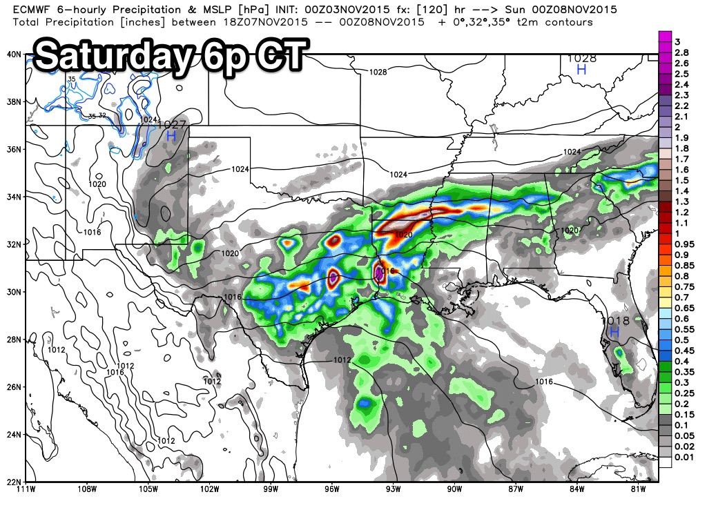
THE WEEKEND: The good news is that we are betting better model agreement, but the bad news is that the models are trending slower, and we could very well have to keep some risk of rain in the forecast all the way through Sunday.
The second part of the upper trough to the west will slowly approach, along with a surface front. We will need to forecast periods of rain Saturday, Saturday night, and into at least Sunday morning. There will certainly be some breaks in the rain, but the rain could come at any time, and some thunder is very possible along the way. The overall severe weather risk for now looks low, and rain amounts of 1 to 2 inches are likely. The high Saturday will be in the low 70s, then dropping back into the 60s Sunday.
NEXT WEEK: The weather looks mostly dry Monday and Tuesday, but another storm system will bring rain and thunderstorms by Wednesday, and possibly Thursday. The latest looks from the GFS model suggests the severe weather threat won’t be especially high, but we need to watch any system this time of the year (our fall tornado season is November and December).
See the Weather Xtreme video for maps, graphics, and more details.
FOOTBALL WEATHER: For the high school playoff games in Alabama Friday night, showers and thunderstorms are likely, and a few lightning delays are very possible. Temperatures will be in the mid to upper 60s at most stadiums.
The biggest college game in the nation is Saturday night in Tuscaloosa, when LSU takes on Alabama at Bryant-Denny Stadium (7:00p CT kickoff). Based on the slower model solutions mentioned above, we will now need to mention a chance of rain during the game, and a thunderstorm is possible as well. Temperatures will be in the mid 60s during the game. I can’t give you specific start/stop times for the rain, but everyone needs to take some rain gear to the stadium.
Auburn is in College Station to take on the Aggies of Texas A&M Saturday night (6:30p CT kickoff)… and like Tuscaloosa we will need to insert a chance of showers, and possibly a thunderstorm for this game. Temperatures will fall from the mid 60s at kickoff into the low 60s by the fourth quarter.
WEATHER BRAINS: Don’t forget you can listen to our weekly 90 minute netcast anytime on the web, or on iTunes. This is the show all about weather featuring many familiar voices, including our meteorologists here at ABC 33/40. Scroll down for the show notes on the new episode we recorded last night.
CONNECT: You can find me on all of the major social networks…
Facebook
Twitter
Google Plus
Instagram
I will be speaking on the campus of the University of Alabama today; be looking for the next Weather Xtreme video here by 4:00 this afternoon. Enjoy the day!
Category: Alabama's Weather
About the Author (Author Profile)
James Spann is one of the most recognized and trusted television meteorologists in the industry. He holds the AMS CCM designation and television seals from the AMS and NWA. He is a past winner of the Broadcast Meteorologist of the Year from both professional organizations.Subscribe
If you enjoyed this article, subscribe to receive more just like it.


