

Warm Today; Rain On The Way
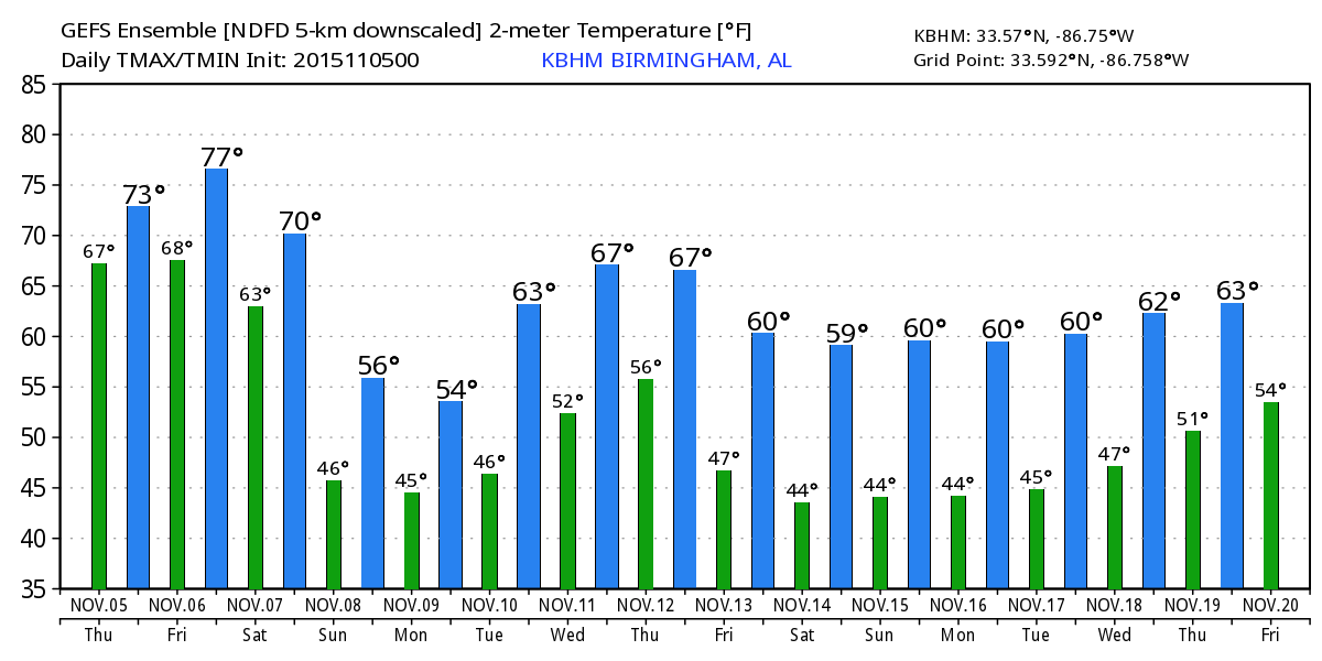
AT DAYBREAK: A quiet morning across the great state of Alabama; there is some dense fog over the southwest counties of the state, otherwise the sky is mostly cloudy with temperatures generally in the 60s. We will rise into the 77 to 80 degree range again today and tomorrow as the warm November weather pattern continues thanks to an upper ridge overhead.
Here are Birmingham’s record highs today and tomorrow…
November 5 83 (2003)
November 6 82 (1938)
I don’t think we hit those levels, but we won’t be too far away.
A few isolated showers are possible this afternoon and tonight, but many communities will stay dry.
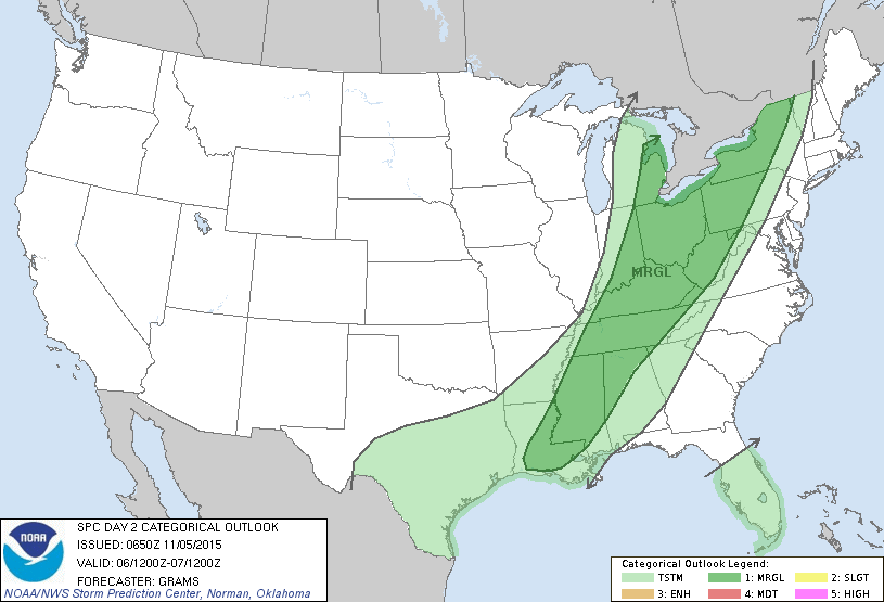
TO THE WEST: Strong to severe storms are possible in a broad zone from Texas to the Great Lakes this afternoon and tonight as the big upper trough over the western U.S. lifts out. Highest severe weather risk of over parts of North Texas, where SPC has a “slight risk” defined.
TOMORROW: With the approach of the upper trough and a surface front, showers and storms will increase across Alabama tomorrow afternoon and tomorrow night. SPC has a “marginal risk” defined for parts of North and West Alabama; surface temperatures will approach 80 tomorrow afternoon making the air somewhat unstable, but the main dynamic support will remain far north of our state.
SATURDAY: The surface front stalls out near the Alabama/Tennessee state line, and with another short wave aloft approaching, our weather will stay wet with periods of rain, and possibly a thunderstorm. The day will be cooler with temperatures holding in the 60s.
Rain lingers into Saturday night before ending very early Sunday morning.
SUNDAY: The day will be noticeably cooler, with a high between 58 and 63 degrees across North/Central Alabama. Some clearing is possible, but clouds will increase again Sunday night.
MONDAY: We have adjusted the forecast to include a chance of rain statewide Monday as a wave forms on the front to the south; this is now supported by both the GFS (American) and ECMWF (European) global models. And, a cold air damming pattern sets up, which will funnel in very cool air into the northern half of the state. It now looks like we won’t get out of the 50s Monday, and a few communities across Northeast Alabama might even hold in the 40s all day. It will be huge change from the recent warmth.
REST OF NEXT WEEK: Tuesday and Wednesday look dry, then a surface front will bring a chance of showers and thunderstorms Thursday. The main upper support will be well to the north, so for now severe weather doesn’t look likely. See the Weather Xtreme video for maps, graphics, and more details.
FOOTBALL WEATHER: For the high school playoff games in Alabama tonight, showers and thunderstorms are a good possibility, and a few lightning delays are possible. Temperatures will be in the mid to upper 60s at most stadiums.
The biggest college game in the nation is Saturday night when LSU takes on Alabama at Bryant-Denny Stadium (7:00p CT kickoff). We will forecast periods of rain during the game; nothing especially heavy, and the risk of a lightning delay looks fairly small for now. Temperatures will fall into the low 60s during the game.
Auburn is in College Station to take on the Aggies of Texas A&M Saturday night (6:30p CT kickoff)… sure looks like the rain will be over by kickoff; we will forecast a clearing sky with only a slight chance of a lingering shower; temperatures will fall from the low 60s at kickoff into the upper 50s by the final whistle.
AT THE BEACH: Dry weather for the coast from Gulf Shores over to Panama City Beach today, then some risk of scattered showers or thunderstorms tomorrow through the weekend with a limited amount of sunshine. See the complete Gulf Coast 7 Day Planner here. The Gulf Coast Beach Forecast is presented by Gulf Shores Plantation by Mandoki Hospitality Vacation Rentals. Escape to Gulf Shores Plantation where memories last a lifetime.
WEATHER BRAINS: Don’t forget you can listen to our weekly 90 minute netcast anytime on the web, or on iTunes. This is the show all about weather featuring many familiar voices, including our meteorologists here at ABC 33/40.
CONNECT: You can find me on all of the major social networks…
Facebook
Twitter
Google Plus
Instagram
Look for the next Weather Xtreme video here by 4:00 this afternoon… enjoy the day!
Category: Alabama's Weather
About the Author (Author Profile)
James Spann is one of the most recognized and trusted television meteorologists in the industry. He holds the AMS CCM designation and television seals from the AMS and NWA. He is a past winner of the Broadcast Meteorologist of the Year from both professional organizations.Subscribe
If you enjoyed this article, subscribe to receive more just like it.


