

Wet Start To The Weekend; Cooler Saturday
RADAR CHECK: A few isolated showers are over Alabama this afternoon… moving north…
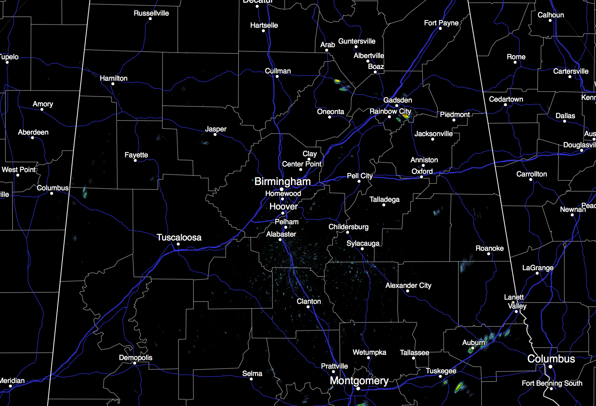
These will fade once the sun goes down, and most communities will stay dry. Temperatures are in the upper 70s in most spots, about ten degrees above average for November 5.
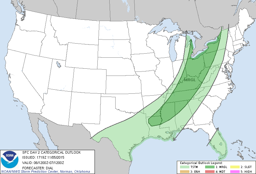
TOMORROW: Our last warm day for a while; the high will be in the 77 to 80 degree range. Morning clouds will give way to intervals of sunshine, and we should begin to see showers forming by mid to late afternoon. Showers and storms become more numerous tomorrow night ahead of an approaching cold front; SPC maintains a “marginal risk” of severe thunderstorms for parts of North and West Alabama, generally along and north of I-59…
A few storms tomorrow night could produce strong gusty winds, and maybe some small hail, but the overall severe weather threat seems low with weakening upper support as the storms move into Alabama.
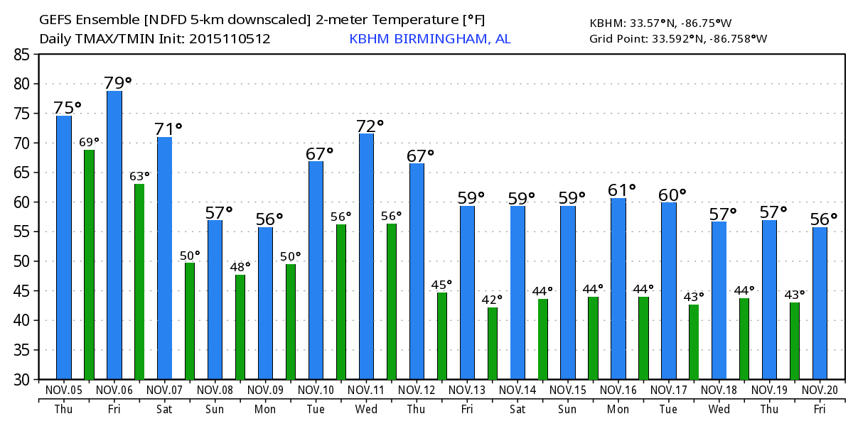
SATURDAY: Wet is the word. Rain is likely with potential for some thunder in spots. There will be some breaks during the day, but it will rain most of the day, with amounts of 1-2 inches likely. The weather will be noticeably cooler, with temperatures holding in the 60s. This means no surface based instability, and severe storms won’t be a problem.
The rain will likely continue Saturday night, diminishing during the late night hours.
SUNDAY: Dry air tries to work in from the north, but the clearing process will be difficult as an “overrunning” pattern sets up with moist air going up and over cooler and drier air at the surface. Some lingering light rain is possible, mainly during the morning. And, the day will be cool with a high only around the 60 degree mark.
NEXT WEEK: Some light rain is possible Monday, which promises to be a cloudy and very cool day. Cold air damming will bring chilly air in here from the northeast; we hold in the 50s all day, a radical change from the recent warmth. Tuesday will be brighter and warmer with a high between 67 and 70. Then, the next chance of showers and storms will come late Wednesday night into Thursday with a cold front; severe weather shouldn’t be an issue with the main dynamics passing far north of Alabama. See the Weather Xtreme video for maps, graphics, and more details.
FOOTBALL WEATHER: For the high school playoff games in Alabama tomorrow night, showers and thunderstorms are a possibility, and a few lightning delays are possible. Temperatures will be in the mid 60s at most stadiums.
The biggest college game in the nation is Saturday night when LSU takes on Alabama at Bryant-Denny Stadium (7:00p CT kickoff). We will forecast periods of rain during the game; nothing especially heavy, and the risk of a lightning delay looks fairly small for now. Temperatures will fall from around 60 degrees at kickoff, into the 50s.
Auburn is in College Station to take on the Aggies of Texas A&M Saturday night (6:30p CT kickoff)… some lingering light rain is possible at the start of the game, but the second half should be dry. Temperatures will fall from around 62 at kickoff, into the 50s by the fourth quarter.
AT THE BEACH: Mostly dry weather for the coast from Gulf Shores over to Panama City Beach today, then some risk of scattered showers or thunderstorms tomorrow through the weekend with only a limited amount of sunshine. See the complete Gulf Coast 7 Day Planner here. The Gulf Coast Beach Forecast is presented by Gulf Shores Plantation by Mandoki Hospitality Vacation Rentals. Escape to Gulf Shores Plantation where memories last a lifetime.
WEATHER BRAINS: Don’t forget you can listen to our weekly 90 minute netcast anytime on the web, or on iTunes. This is the show all about weather featuring many familiar voices, including our meteorologists here at ABC 33/40.
CONNECT: You can find me on all of the major social networks…
Facebook
Twitter
Google Plus
Instagram
Look for the next Weather Xtreme video here by 7:00 a.m. tomorrow…
Category: Alabama's Weather
About the Author (Author Profile)
James Spann is one of the most recognized and trusted television meteorologists in the industry. He holds the AMS CCM designation and television seals from the AMS and NWA. He is a past winner of the Broadcast Meteorologist of the Year from both professional organizations.Subscribe
If you enjoyed this article, subscribe to receive more just like it.


