

Rainy Saturday
An upper trough to our west is once again feeding a combination of Pacific and Gulf moisture into the Southeast US. Rain blanketed a good deal of North and Central Alabama overnight with a few embedded thunderstorms to contend with. Most of the thunderstorms were confined to Central Alabama south of Interstate 20, so those did not lead to too many football game delays. And the weekend will continue to be wet at least for the first half with rain and storms ahead of a cold front moving through the Southeast US.
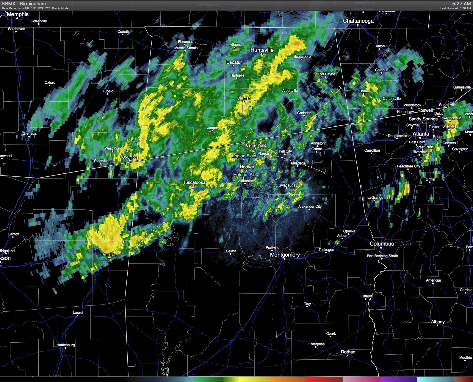
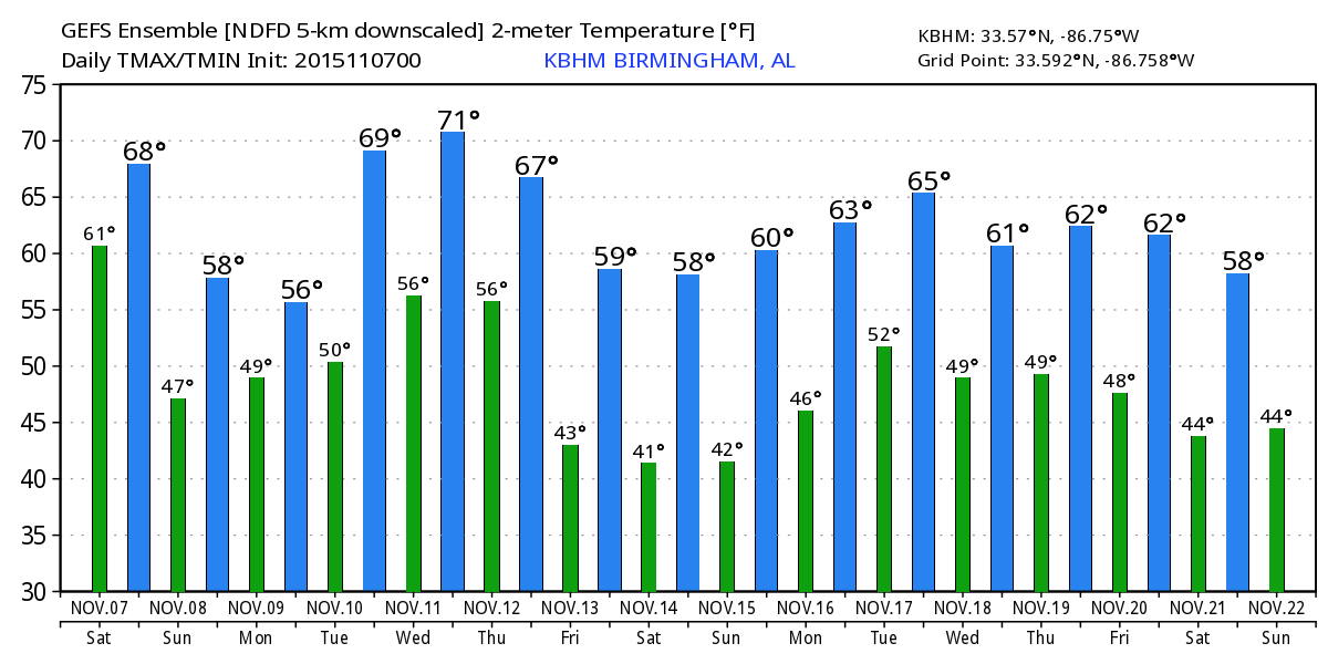
The front is expected to reach the Gulf by Saturday evening which should bring a temporary end to the rain and storm threat. With clouds and rain occurring much of Saturday, temperatures are expected to stay in the middle 60s or fall just a little. It will also be turning colder tonight with lows Sunday morning dipping back to near 50. While we will see a few peeks at the sun on Sunday, the temperature is not expected to rise much with highs struggling to get into the lower 60s.
For the Alabama/LSU game tonight at Bryant-Denny Stadium with a 7:00 pm kickoff, there will be light rain as the game begins, but rain should end during the game. Temperatures will fall from 60 degrees at kickoff into the 50s so besides the rain gear you will need wear something for colder conditions. We don’t expect any issues with lightning. And, for tailgaters, understand rain will be a threat for much of the day today in Tuscaloosa before the kickoff. Auburn takes on the Aggies of Texas A&M at 6:30 pm at College Station; there is just a small risk of a lingering shower during the first half; otherwise dry with temperatures falling into the 50s.
And if you are headed to the beach, it will be wet with scattered showers and storms into Monday. From Monday afternoon through the week, the weather should be fairly nice with highs in the upper 70s and lows dropping back to near 60. You can find the complete Gulf Coast 7 Day Planner here. The Gulf Coast Beach Forecast is presented by Gulf Shores Plantation by Mandoki Hospitality Vacation Rentals. Escape to Gulf Shores Plantation where memories last a lifetime.
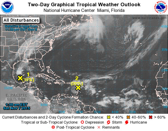
The National Hurricane Center is keeping an eye on two areas of disturbed weather, one in the Gulf of Mexico and one in the northern Leeward Islands. Neither system is forecast to amount to much for the next couple of days. The one in the Gulf will interact with the cold front and be absorbed. The one southeast of Puerto Rico could become better organized as it moves on a northwesterly course that will take it into the Bahamas early next week. We need to remember that hurricane season does not end until the end of November.
Monday we’ll see another short wave move by just to our north. A surface high pressure system centered over eastern Pennsylvania will set up conditions for cold air damming, also known as the wedge. This will bring a chance for rain to the area once again and keep temperatures down with highs only rising to around 60.
The upper air pattern shifts to a near zonal flow on Tuesday, but with slight ridging. All eyes will be focused to our west as a deep trough rotates into the Southwest US. This trough will eject out to the northeast by Thursday dragging a cold front into and through the Southeast US late Wednesday and early Thursday. With the dynamic support of the upper low well north of us over the Great Lakes, the front will be losing steam, but showers will remain a possibility ending but the latter half of Thursday.
Then our weather really becomes nice with the closed low anchored just of Lake Huron and a trough over the eastern half of the country. This will combine with a late surface highs settling into the Lower Mississippi River Valley to bring cooler and much drier air into the Southeast US with highs by Saturday only in the lower to middle 60s and lows dipping back to near 40 – some very pleasant Fall weather.
Looking further forward into voodoo country, the GFS keeps our weather somewhat uneventful through the 18th. A large upper ridge over the Southwest Atlantic along with a trough coming out of the Rockies will once again place the Southeast US in a moisture rich environment that could spell more rain.
You can expect to see the next Weather Xtreme Video here first thing on Sunday morning, at least by 8 am or so. I’m heading out for Greene County this morning to participate in the Fall Festival being held today in Sawyerville. I’ll have a few items to hand out and I’ll be available to program any weather radios people bring by. Hope the rain doesn’t interfere with the festival too much.
-Brian-
Category: Alabama's Weather
About the Author (Author Profile)
Brian Peters is one of the television meteorologists at ABC3340 in Birmingham and a retired NWS Warning Coordination Meteorologist. He handles the weekend Weather Xtreme Videos and forecast discussion and is the Webmaster for the popular WeatherBrains podcast.Subscribe
If you enjoyed this article, subscribe to receive more just like it.


