

The Rain That Won’t Leave
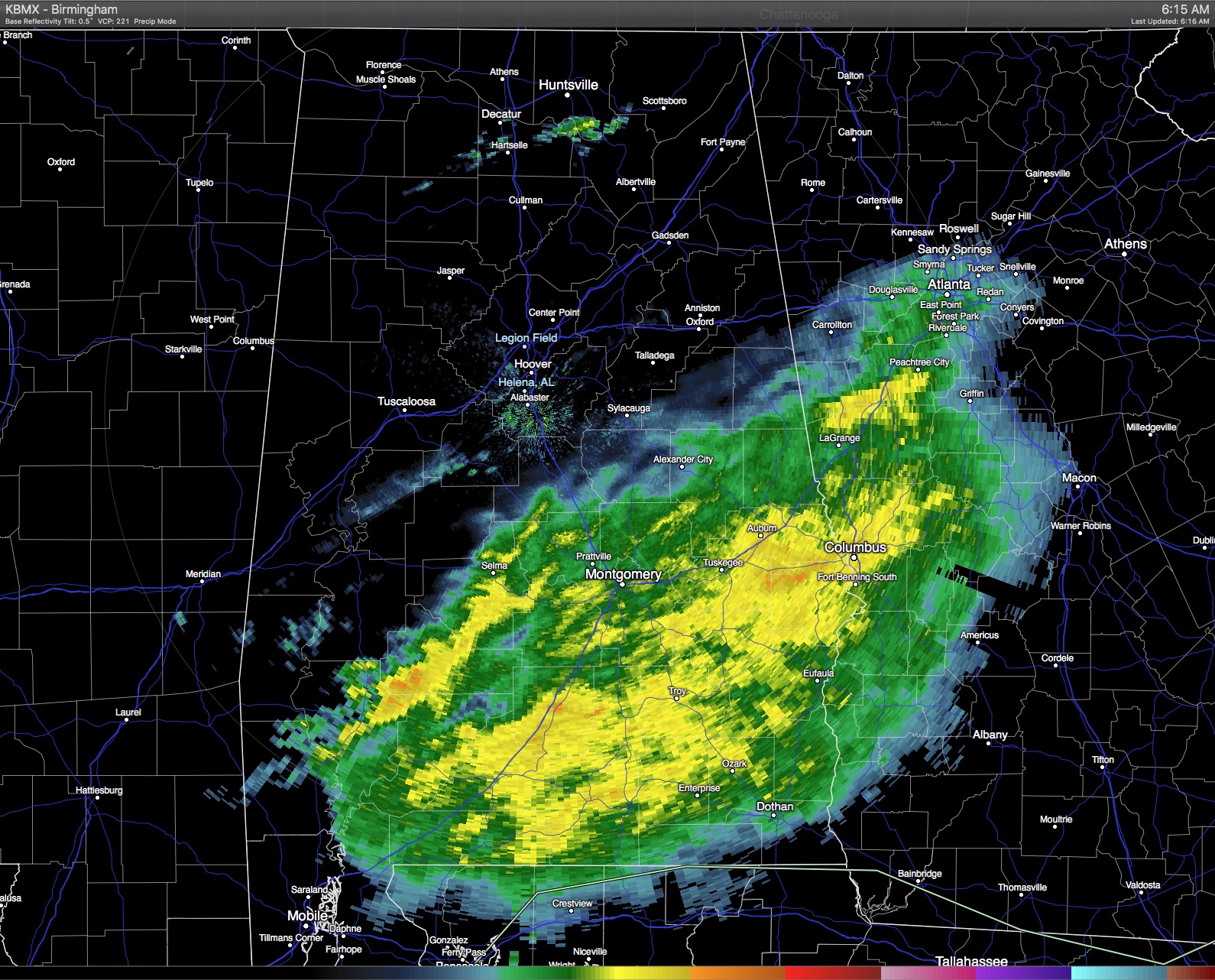
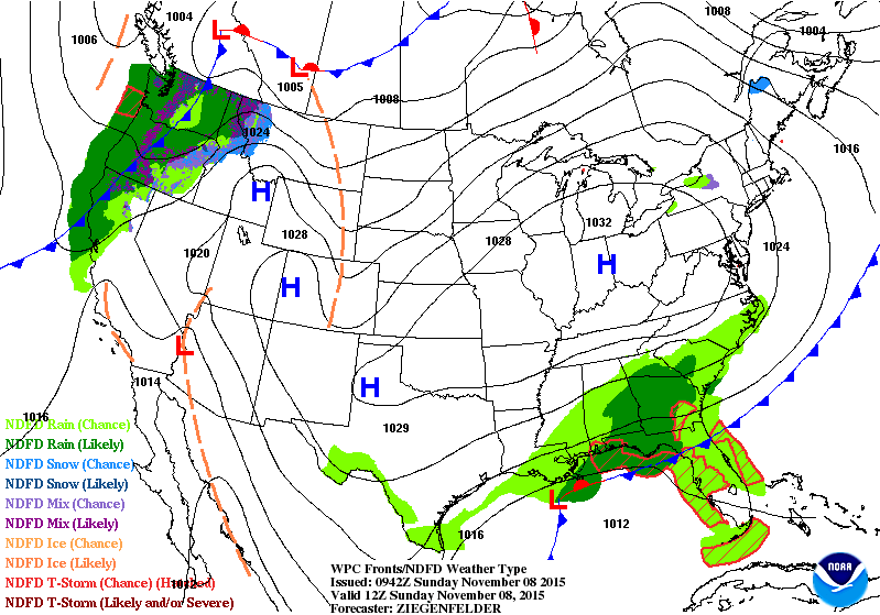
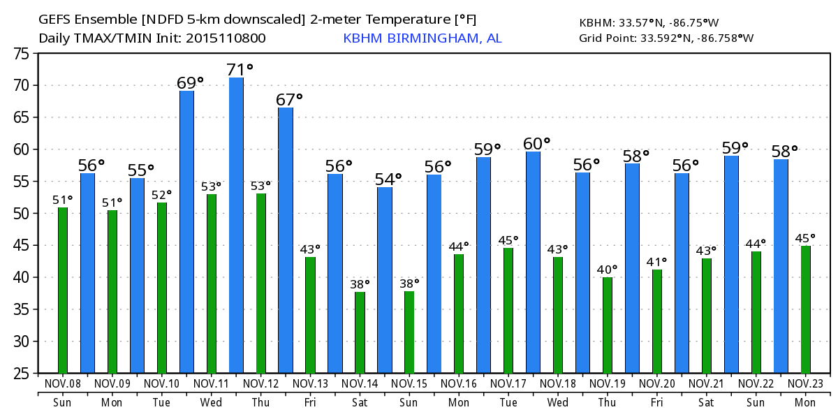
It seems like the rain just won’t end. The radar this morning shows the rain covering about the southern half of Alabama while satellite imagery shows clouds covering much of the state. A surface low was moving along the cold front which made it to the Gulf Coast yesterday. That surface low will help to add to the cold air damming pattern, also called the wedge, which develops with a strong surface high to our northeast, generally centered over Pennsylvania. The wedge will set up an easterly flow regime which will keep Central Alabama cloudy, cool, and damp. I do not expect to see heavy rain as we’re seeing over Southeast Alabama this morning, but rather light rain. You might need a jacket today, too, as temperatures are not expected to get out of the 50s.
If you are headed to the beach, it will be wet with scattered showers and storms into Monday. From Monday afternoon through the week, the weather should be fairly nice with highs in the upper 70s and lows dropping back to near 60. See the complete Gulf Coast 7 Day Planner here. The Gulf Coast Beach Forecast is presented by Gulf Shores Plantation by Mandoki Hospitality Vacation Rentals. Escape to Gulf Shores Plantation where memories last a lifetime.
At 500 millibars, a strong trough is rotating into the West Coast while a smaller short wave will be kicking out across the Ohio River Valley. This short wave will provide the necessary push to get the wet weather out of here. So look for the cloudy and rainy conditions to depart our area on Monday with some chance for a few peeks at the sun during the afternoon. The day will remain cool with highs once again struggling to get out of the 50s.
We get a break in the action for Tuesday and Wednesday with a high surface high over the Ohio and Tennessee River valleys. This pattern should allow for some good sunshine and bring temperatures back up with highs around 70 or so. But this break won’t last long. A strong short wave with a closed low aloft will generate a strong surface low in the Central Plains Wednesday. The upper closed low will move northeast with the surface low into the Great Lakes by midday Thursday. This will drag a front through the Southeast US. Thunderstorms along the front are expected to roll through Central Alabama between about midnight and noon on Thursday. This is a fairly strong system, so there is potential for severe thunderstorms. While the primary dynamics are well north of Central Alabama, we do note that the shear parameters for severe weather seem adequate, but the instability elements are limited. We’ll need to be watchful of how this evolves in future run.
This front is forecast by both the GFS and ECMWF to move through quickly exiting the state Thursday afternoon. This paves the way for a large surface high to settle into the Lower Mississippi River Valley as the upper trough ushers in some colder weather for the weekend. Highs Friday through Sunday should be on the cool side with values in the 60s. Morning lows will be in the upper 30s and lower 40s. Sunday morning may be the coolest with the surface high right over us allowing for calm wind and great radiational cooling.
And, as you probably have guessed, the folks in the weather office will stay quite busy with another strong upper trough forecast to come through the flow around the 16th and 17th. That one will be followed by yet another one around the 22nd. And that one, yup, is being followed closed by still another one.
The Fall Festival in Sawyerville that was scheduled for yesterday was postponed to next Saturday. I still plan to attend the event next Saturday when the weather looks a lot better than was they were facing for yesterday. James Spann will have the next Weather Xtreme Video here first thing on Monday morning. Don’t forget to check back here often for notes on Alabama’s ever changing weather.
-Brian-
Category: Alabama's Weather
About the Author (Author Profile)
Brian Peters is one of the television meteorologists at ABC3340 in Birmingham and a retired NWS Warning Coordination Meteorologist. He handles the weekend Weather Xtreme Videos and forecast discussion and is the Webmaster for the popular WeatherBrains podcast.Subscribe
If you enjoyed this article, subscribe to receive more just like it.


