

Frost/Freeze Potential This Weekend
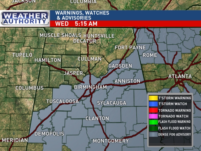
FOGGY START: A dense fog advisory is up for much of Central and South Alabama early this morning; visibility is down to a fraction of a mile in spots…
Once the fog burns off, we expect a very nice day, with a good supply of sunshine through scattered clouds along with a high pretty close to 70 degrees.
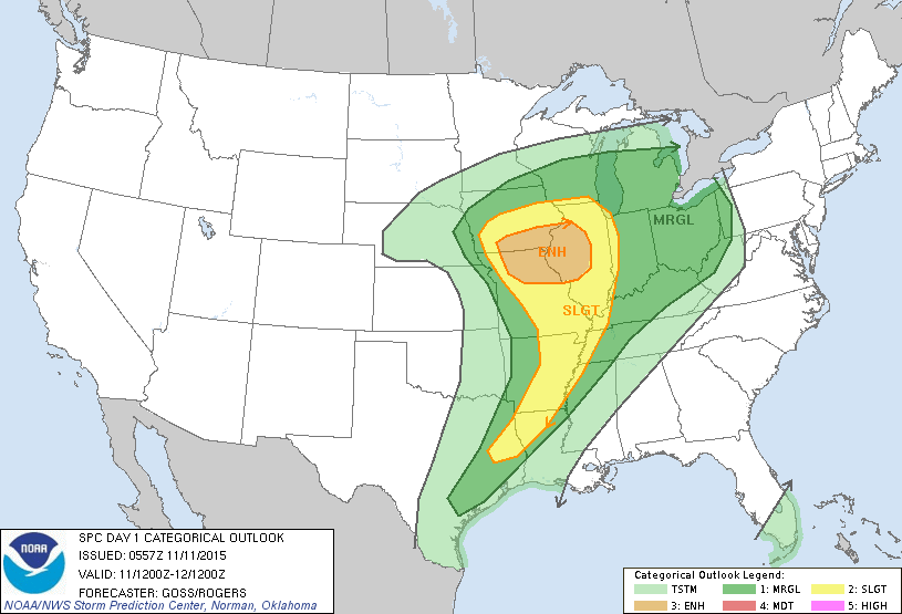
NORTH AND WEST OF ALABAMA: A deepening surface low will move from eastern Colorado to the Great Lakes during the next 24 hours, and will bring blizzard conditions to parts of Colorado/Kansas/Nebraska, and a severe weather threat from near Chicago to Houston. Higher severe weather probabilities are from St. Louis to Des Moines.
The trailing cold front will push a band of showers into Alabama late tonight, after midnight… those showers will be weakening with no surface based instability and little upper support around here. No risk of severe weather, probably no thunder, and very light rain amounts. The main threat of showers will come from 1:00 until 6:00 a.m.
The sky becomes mostly sunny during the day tomorrow as a new surge of dry air arrives; the high will be in the 60s.
FRIDAY AND THE WEEKEND: Dry air means sunny days and clear cold nights. The GFS is printing a low of 33 for Birmingham early Saturday morning; frost should be fairly widespread, and colder pockets will see a freeze. Many valley locations will drop down into the 20s. And, Sunday morning should be just as cold. The high Friday will be in the low 60s, followed by upper 50s Saturday, and then we go back into the low 60s Sunday afternoon.
NEXT WEEK: A dynamic storm system will impact Alabama with a good chance of rain and storms at times Tuesday through at least Thursday. It remains to be seen if this will be a severe weather setup; for now instability values look very low, but that could change. Flooding could be more of a concern… see the Weather Xtreme video for maps, graphics, and more details.
FOOTBALL WEATHER: Clear and cold for the Friday night high school playoff games; temperatures will fall into the 40s.
Auburn hosts Georgia Saturday at Jordan Hare Stadium (11:00a CT kickoff)… the sky will be sunny with temperatures rising from near 54 at kickoff to 58 by the final whistle.
Alabama takes on Mississippi State over in Starkville at Davis Wade Stadium (2:30p CT kickoff)… the expect a sun filled sky. About 62 degrees at kickoff, falling into the low 50s by the fourth quarter.
AT THE BEACH: A small risk of a shower tomorrow, otherwise the weather is looking dry on the coast from Gulf Shores east to Panama City Beach through the weekend; See the complete Gulf Coast 7 Day Planner here. The Gulf Coast Beach Forecast is presented by Gulf Shores Plantation by Mandoki Hospitality Vacation Rentals. Escape to Gulf Shores Plantation where memories last a lifetime.
WEATHER BRAINS: Don’t forget you can listen to our weekly 90 minute netcast anytime on the web, or on iTunes. This is the show all about weather featuring many familiar voices, including our meteorologists here at ABC 33/40.
CONNECT: You can find me on all of the major social networks…
Facebook
Twitter
Google Plus
Instagram
I will be speaking to the kids at the University of Alabama Child Development/Research Center this morning in Tuscaloosa… look for the next Weather Xtreme video here by 4:00 this afternoon. Enjoy the day!
Category: Alabama's Weather
About the Author (Author Profile)
James Spann is one of the most recognized and trusted television meteorologists in the industry. He holds the AMS CCM designation and television seals from the AMS and NWA. He is a past winner of the Broadcast Meteorologist of the Year from both professional organizations.Subscribe
If you enjoyed this article, subscribe to receive more just like it.


