

Mississippi Storms Prompting Warnings, Including Tornado Warnings
We continue to monitor strong storms tonight over Central Mississippi. They have intensified about 90 minutes ago and prompted tornado warnings.
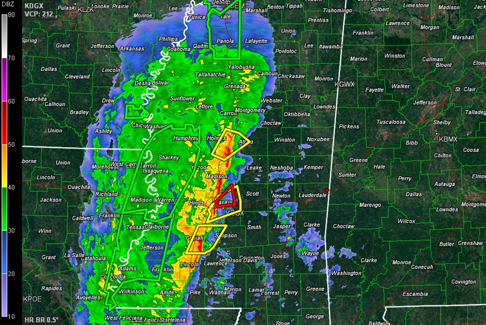
One set of warnings was located just north of Jackson, in the Canton area. A possible tornado touched down 2 miles south of Edwards in Hinds County, just west of Jackson. It had a possible debris signature and trees are down. That storm is approaching Canton. It appears that it might be at the comma head of a mesoscale convective vortex near Yazoo City. The NWS in Jackson is now tending toward severe thunderstorm warnings on this set of storms, which is a good sign.
A second tornado warned storm was in the Brookhaven area, south of Jackson. Rotation decreased in this storm and the latest warning on this storm.
At 10:55, the NWS in Jackson is issuing a torando warning for Rankin County, which rotation has increased near the Jackson International Airport, around Flowood, east of the city.
Vorticity, or spin and energy in the atmosphere, is being maximized along the flank of the mesoscale convective system as it translates north northeast. That may be because a strong low level jet has been lifting across that area over the past couple of hours, improving upward motion. Inflow into the system appears to be increasing, as evidenced by showers moving north northwest in advance of the system.
At the same time, a narrow funnel of instability continues to translate eastward ahead of the storms, providing the fuel the updrafts need to survive. It appears that wind shear will continue strong, and perhaps even intensify.
SO, it appears that the storms will hold together as they reach the Alabama/Mississippi border between 3-5 a.m. Additional storms will begin to form over areas ahead of the main line and merge with it. These storms will reach Tuscaloosa between 6-8 a.m. and Birmingham between 8-10 a.m. They should reach East Alabama, around Gadsden and Anniston between 11 a.m. and 1 p.m.
Widespread rain and thunderstorms continue behind the front line. The system has slowed its forward progress resulting in heavy rainfall amounts. 2-4 inch amounts are widespread. Wednesday will be a rainy day across Central Alabama, for sure.
Expect another update by 1:30 unless conditions warrant earlier. We will continue monitoring the severe weather situation overnight and have update as necessary.
Category: Alabama's Weather, Severe Weather
About the Author (Author Profile)
Bill Murray is the President of The Weather Factory. He is the site's official weather historian and a weekend forecaster. He also anchors the site's severe weather coverage. Bill Murray is the proud holder of National Weather Association Digital Seal #0001 @wxhistorianSubscribe
If you enjoyed this article, subscribe to receive more just like it.


