

Severe Thunderstorm Warning Pickens/Sumter
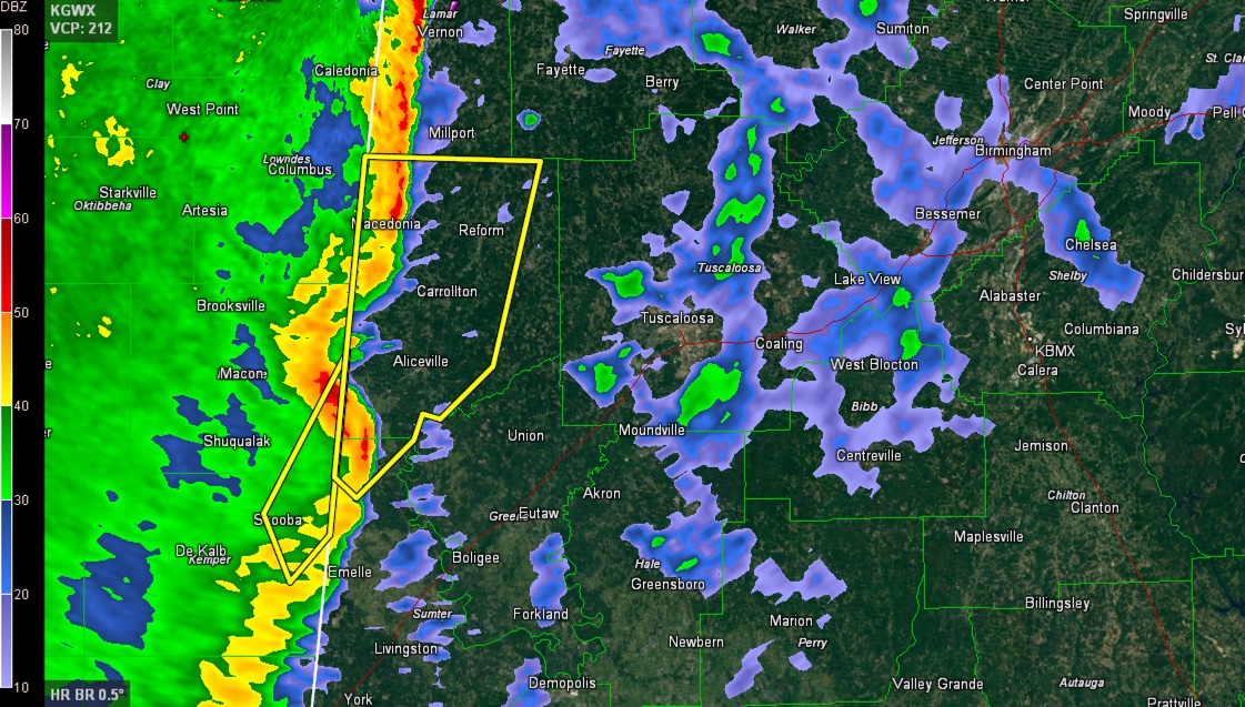
The line of storms is into West Alabama’s Marion, Lamar, Pickens and Sumter Counties.
The system has a comma head near Tupelo MS indicating some type of mesoscale convective vortex. The storms associated with this feature produced a tornado warning for Monroe County MS earlier. No reports of damage were received.
There is also a kink in the line northwest of Aliceville. This kink is strongly indicative of damaging winds. An isolated spinup tornado is not out of the question as well.
This part of the line is moving north northeast into an area characterized by extremely high low level shear. Helicity, or spin, inthe atmosphere in the surface to 1 km layer is up to 650 m2/s2 over Marion and Lamar Counties. Followers of the blog will know that those values are about as high as we see in Alabama severe weather.
Fortunately, it is just at the very apex of a small sliver of instability, but any thunderstorm updrafts that tap it will have a tremendous amount of spin to draw from. There is a good bit of lightning associated with the storms from Marion down through Pickens Counties, so we know there are decent updrafts there that can do just that.
Aliceville, Carrollton and Reform are in the path of the feature.
Be in a safe place as these dangerous storms approach.
THE NATIONAL WEATHER SERVICE IN BIRMINGHAM HAS ISSUED A
* SEVERE THUNDERSTORM WARNING FOR…
PICKENS COUNTY IN WEST CENTRAL ALABAMA…
NORTH CENTRAL SUMTER COUNTY IN WEST CENTRAL ALABAMA…
* UNTIL 515 AM CST
* AT 427 AM CST…A SEVERE THUNDERSTORM WAS LOCATED OVER
COOKSVILLE…OR 13 MILES SOUTHWEST OF ALICEVILLE…MOVING NORTHEAST
AT 50 MPH.
HAZARD…60-65 MPH WIND GUSTS.
SOURCE…RADAR INDICATED.
IMPACT…EXPECT DAMAGE TO ROOFS…SIDING AND TREES.
* LOCATIONS IMPACTED INCLUDE…
ALICEVILLE…REFORM…CARROLLTON…PICKENSVILLE…ETHELSVILLE…
MCMULLEN…BEVILL LOCK AND DAM…JOHNSTON LAKE…GARDEN…PANOLA…
GAINESVILLE LAKE CAMPGROUND…GEORGE DOWNER AIRPORT…PINE GROVE…
NORTH PICKENS AIRPORT…COCHRANE…MCSHAN…FOREST…SHAW…
DILLBURG AND OWENS.
Category: Severe Weather
About the Author (Author Profile)
Subscribe
If you enjoyed this article, subscribe to receive more just like it.


