

Storms Pushing East
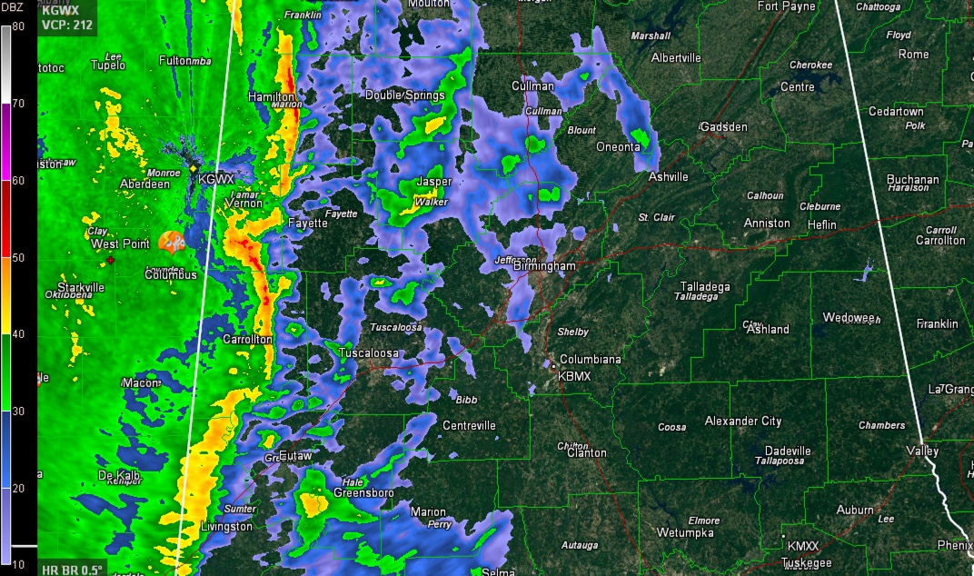
A line of thunderstorms and heavy rain ahead of a cold front has pushed into western Alabama early this morning. The leading edge extends from Russellville to Winfield to Belk to Gordo to Union to Gainesville.
There is lots of heavy rain, some gusty winds and a significant amount of lightning with the storms. The heaviest lightning is over northern Lamar and Marion Counties, associated with a mesoscale convective vortex. This comma head shaped feature will move northeast across Lamar, Fayette, Marion and into Winston Counties over the next couple of hours. There is a chance of damaging winds and even an isolated small spin up tornado with this feature.
The line of storms is pushing east at 15 mph and will affect Marion, Lamar, Pickens and Sumter Counties over the next hour.
Several hours of rain continues behind the leading edge storms. Already well over 2.25 inches of rain in Starkville from the system and there is flooding in the City of Meridian. Here in Alabama, the amount of rain that it would take to cause flash flooding is fairly high so we should escape widespread flooding problems. But that doesn’t mean we won’t see some flooding today as 2-4 inches of rain falls.
There is an amazing amount of Gulf moisture being pulled northward into the Southeast by the powerful upper level system, which is centered over Oklahoma and Texas this morning and a weakening surface low, which is over Iowa.
A tornado watch remains in effect until 9 a.m. CST for southern portion of West Alabama, as far north as Pickens, Sumter, Greene and Hale Counties.
Category: Alabama's Weather, Severe Weather
About the Author (Author Profile)
Bill Murray is the President of The Weather Factory. He is the site's official weather historian and a weekend forecaster. He also anchors the site's severe weather coverage. Bill Murray is the proud holder of National Weather Association Digital Seal #0001 @wxhistorianSubscribe
If you enjoyed this article, subscribe to receive more just like it.


