

The Chill Has Arrived
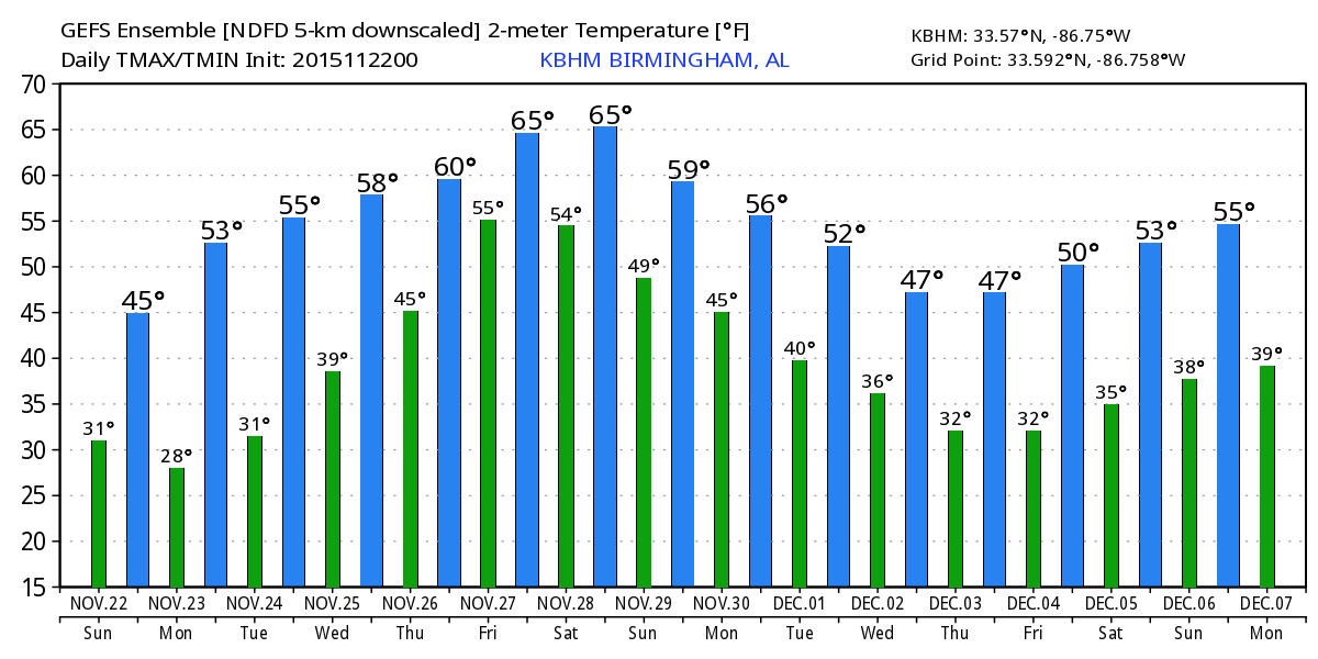
Central Alabama is waking up to the chill we promised along with a fairly stout north wind. Temperatures this morning were in the 30s across all of North and Central Alabama, but because the wind stayed up overnight and into this morning, frost formation was kept to a minimum. That won’t be so on Sunday as a surface high pressure settles into Alabama and Mississippi allowing the wind to go calm. That along with a clear sky will allow excellent radiational cooling, so temperatures are expected to fall into the 20s across all of North and Central Alabama. There is a good possibility that some of the typically colder locations will see morning lows around 18 or 19. With the likelihood of a freeze, the NWS has posted a freeze warning from 9 pm tonight through 9 am on Monday. If you have any plants that are affected by freezing weather, you will need to take protective action for them. Also, please remember our animal friends and be sure they have a sufficiently warm place tonight and early Monday.
The broad trough aloft will move off the New England coast during the day Monday, so the warm-up will start quickly. Even with the warm-up beginning we expect to be around freezing for lows on Tuesday morning. By Tuesday the warm-up has really gathered some steam as the upper ridge comes into play from late Tuesday through the end of the week. A short wave trough will scoot by on Wednesday, but with little or no moisture to work with, there won’t be any rain and all we’ll see is some passing clouds. Thanksgiving Day should be partly cloudy for Central Alabama with highs in the 60s.
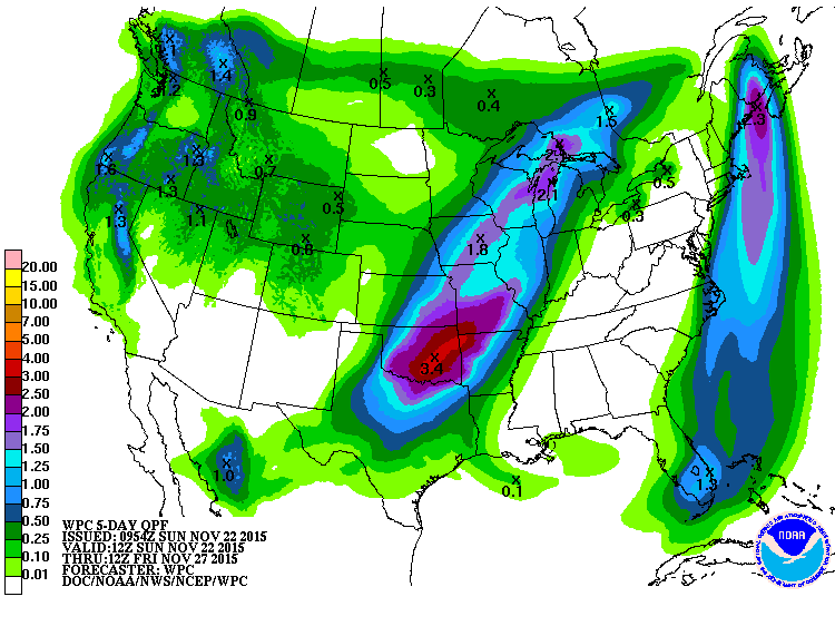
But by mid-week we’ll begin watching a deep trough and closed low coming into the Four Corners area of the Southwest. A surface storm system (low pressure) will generate some snows for the Rockies, and it will slowly move northeastward into the Great Lakes by Friday. Because the upper pattern is forecast to shear out north of the Gulf of Mexico ridge, the cold front should not reach us until Saturday, perhaps as early as late Friday. Unfortunately this is likely to bring rain to the area including the Iron Bowl as Alabama and Auburn meet for the 80th edition of one of the greatest rivalries in college football. Kickoff time is 2:30 pm CST, and for now, we need to mention showers for at least the first half of the game. This doesn’t look like a severe weather event with the best dynamics well north of the state, but if you have plans to be on the Plains, you will want to take the rain gear. We’ll be watching future model output and will refine the forecast as the event draws closer.
If you are heading toward the beach, weather will be improving today as the rain has moved east, but the air is much cooler thanks to the cold front that pushed through the region. Today and tonight will be quite chilly. Highs today are only in the 50s with lows tonight falling into the 30s. The warming trend will start Monday and continue through the Thanksgiving holiday. See the complete Gulf Coast 7 Day Planner here . The Gulf Coast Beach Forecast is presented by Gulf Shores Plantation by Mandoki Hospitality Vacation Rentals. Escape to Gulf Shores Plantation where memories last a lifetime.
Week 2, or voodoo country, appears to stick with an active pattern. We’ll see a minor trough on Monday, November 30th, to close out the month, with a fairly deep trough forecast for December 2nd. That trough deepens across the eastern US on the 4th promising another round of freezing temperatures. By the time we reach the 7th, the pattern has gone nearly zonal for the southern portion of the US, so our weather should be fairly pleasant with temperatures about as expected for the first part of December.
I had a great time visiting with folks at Thanksgiving in the Street in Tuscaloosa yesterday. I certainly appreciated their invitation plus I got to enjoy another Thanksgiving meal. James Spann will be here on Monday morning with the next edition of the Weather Xtreme Video. Stay warm and Godspeed.
-Brian-
Category: Alabama's Weather
About the Author (Author Profile)
Brian Peters is one of the television meteorologists at ABC3340 in Birmingham and a retired NWS Warning Coordination Meteorologist. He handles the weekend Weather Xtreme Videos and forecast discussion and is the Webmaster for the popular WeatherBrains podcast.Subscribe
If you enjoyed this article, subscribe to receive more just like it.


