

The 2015 North Atlantic Hurricane Season
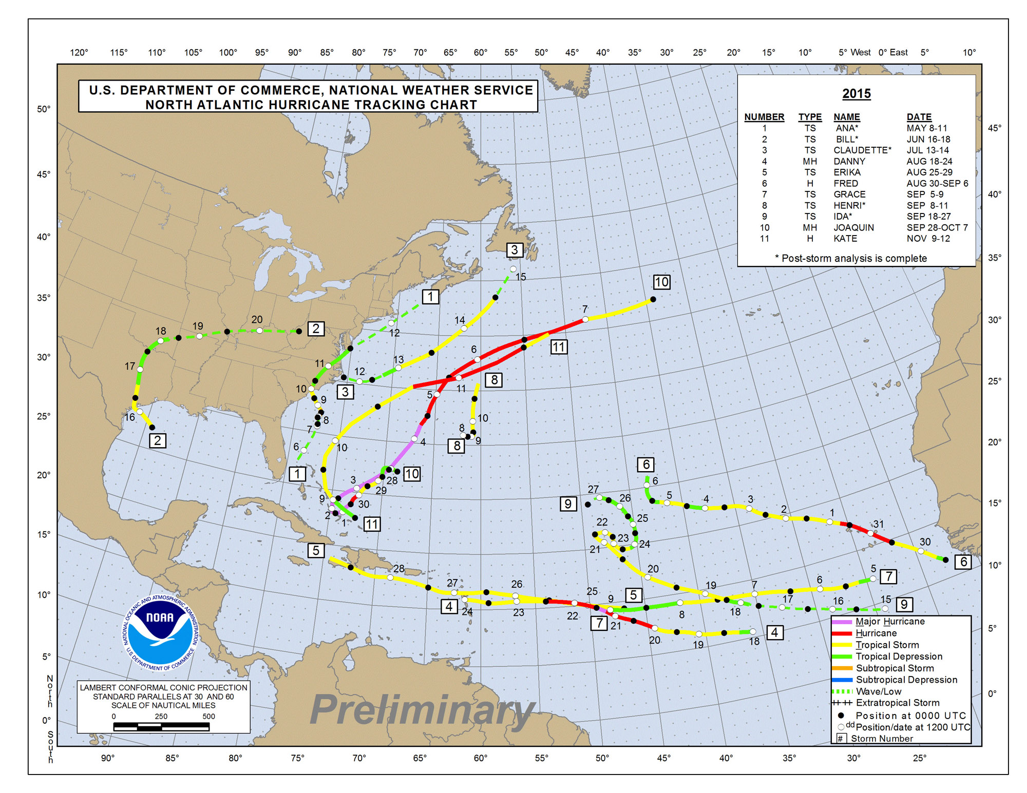
The 2015 North Atlantic Hurricane Season was fairly slow, as had been predicted in most seasonal forecasts. There were eleven named storms, which is very close to the long term average of 11.5. Four of the storms became hurricanes and two went on to become major hurricanes, below the long term averages of 6.1 hurricanes and 2.6 major hurricanes.
The season got started well before the official start date of June 1st, when Tropical Storm Ana formed from a non-tropical low on May 8th. The system had peak winds of 60 mph as it crossed over the Gulf Stream. It would weaken as it moved off the Gulf Stream and go on to make landfall on the northeastern coast of South Carolina with winds of 45 mph.
A named storm forms in the Atlantic in June in just about every other year on average, and Bill did just that, jumping straight to tropical storm status on the first advisory based on aircraft reconnaissance data. The storm was designated Bill on the evening of June 15th with a well defined circulation center some 175 miles east southeast of Corpus Christi, Texas. It made landfall later on the 16th on Matagorda Island, with a central pressure of 997 mb and top winds of 60 mph.
The storm remained unusually organized as it made the trek northward across Texas and into Oklahoma, perhaps aided by the “brown island effect” of saturated ground from recent heavy rain over the southern Plains. Newport, Oklahoma picked up a two day rain total of 11.52 inches. I-35 was closed in the Arbuckle Mountains due to a rock slide.
A tropical depression formed about 250 miles east northeast of Cape Hatteras on July 16th. SIx hours later it was upgraded to Tropical Storm Claudette. The storm weakened as it moved northeastward and merged with a frontal boundary, but it still produced adverse weather in Newfoundland, where flights were canceled.
Danny was a Cape Verde storm that became the season’s first major hurricane with top winds of 115 mph. Danny would weaken due to dry air and wind shear and dissipated before reaching the Leeward Islands.
Tropical Storm Erika was another Cape Verde storm like Danny, but never got its act together. The storm formed on August 25th and steamed across the Atlantic, making landfall on Dominica and in Hispaniola. The storm dissipated while dodging Cuba, but brought heavy rains to South Florida.
Hurricane Fred formed from a very strong tropical wave that moved off Africa on August 29th, became a depression on the 30th and quickly became a hurricane on the 31st. It is the furthest east that a hurricane has ever formed in the Atlantic and prompted hurricane warnings for the Cape Verde Islands for the first time in history.
The season entered a boring period, with unremarkable tropical storms named Grace, Henri and Ida forming over the open Atlantic and dissipating before affecting any land areas.
Hurricane Joaquin stole the show during the 2015 Atlantic Hurricane Season. Joaquin formed east of the Bahamas on September 28th and became a tropical storm on the following day as it moved in a southwesterly direction toward the Bahamas. It would continue to strengthen and became a major hurricane on the evening of the 30th. Hurricane Joaquin would affect the Bahamas as a category four hurricane, but would weaken as it moved through the islands. Joaquin turned to the northeast and very nearly achieved category five status when its top winds reached 155 mph. It was the most intense Atlantic hurricane since Igor in 2010. Fortunately, Joaquin weakened before it impacted Bermuda with heavy rain and tropical storm force winds.
The official National Hurricane Center forecasts predicted for three days that Joaquin could impact the eastern United States, despite strong indications from the European model that the storm would remain well offshore. This led to considerable angst along the East Coast and a look at how the National Hurricane Center’s Cone of Uncertainty is used in such situations.
Part of the moisture pulled northward by Joaquin would be pulled back into South Carolina by a big upper level low, which resulted in catastrophic flooding in the Palmetto State.
The final named storm was Kate, which became a hurricane on November 11th, making it the latest hurricane since Epsilon in 2005. Kate affected the southeastern Bahamas, but recurved off the East Coast of the U.S. and missing Bermuda.
While the storm counts were slightly below the long term averages, the energy expended by the eleven storms was just 59 percent of normal. The Atlantic basin was dominated by El Nino conditions during the hurricane season. The higher than normal wind shear contributed to the below normal activity.
For the tenth straight year, there has been no landfall of a major hurricane in the United States. It hasn’t happened since Hurricane Wilma in October 2005. In addition, Florida has not bit hit by ANY hurricane of any intensity since Wilma.
About the Author (Author Profile)
Bill Murray is the President of The Weather Factory. He is the site's official weather historian and a weekend forecaster. He also anchors the site's severe weather coverage. Bill Murray is the proud holder of National Weather Association Digital Seal #0001 @wxhistorianSubscribe
If you enjoyed this article, subscribe to receive more just like it.


