

Record Warmth; Strong Storms
RADAR CHECK: Strong storms continue across parts of Central and South Alabama at daybreak on this Christmas Eve…
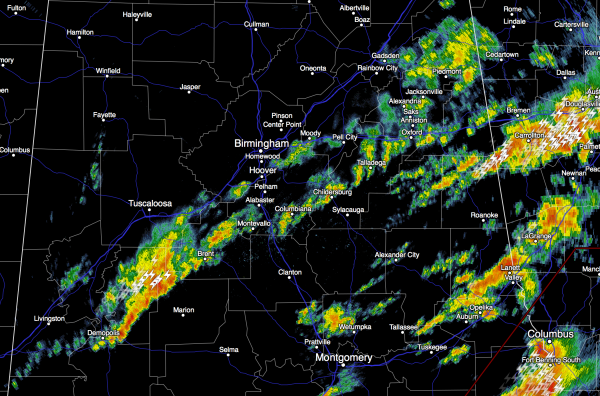
As forecast, the severe weather event yesterday and last night was high impact. At least seven people were killed, and at least 40 people injured. The deaths were from Mississippi, Tennessee, and Arkansas. Among the dead was a 7-year-old boy in Holly Springs, Mississippi; a horrifying tragedy two days before Christmas. We were blessed; a layer of slightly warmer air over Alabama resulted in lower lapse rates, and the storms never quite reached their potential despite the “powder keg” atmosphere with dewpoints around 70 degrees. Just a few degrees of warmth between 15,000 and 20,000 feet can make a big difference.
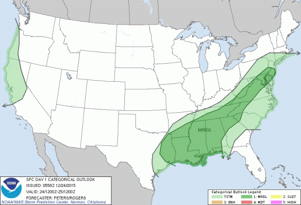
THE DAY AHEAD: SPC has a “marginal” severe weather risk up for most of Alabama today and tonight…
Some of the storms today and tonight will be capable of producing gusty winds, but the tornado threat is minimal. Otherwise, today will be warm for late December; the GFS is printing a high of 77 degrees, and if we reach that it will tie the record for today, set in 1964.
CHRISTMAS DAY: Not much change. Record warmth is likely; the record high tomorrow is 74 set in 1987, and a pretty good chance we slip past that by afternoon. The sky will be mostly cloudy, and we will continue the risk of few showers, and maybe even a thunderstorm. In fact, SPC has the northern part of Alabama in a “marginal” severe weather risk tomorrow and tomorrow night.
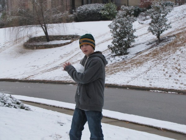
Quite contrast to Christmas Day five years ago, when many North Alabama communities had their first “White Christmas” on record. Photo below was taken by me; that is our son Ryan, who at the time was 13 years old.
THE WEEKEND: The December warmth continues. Highs in the mid 70s Saturday and Sunday; more clouds than sun with a chance of scattered showers both days.
NEXT WEEK: Yet another dynamic storm system will bring the threat of strong storms to Alabama on Monday.
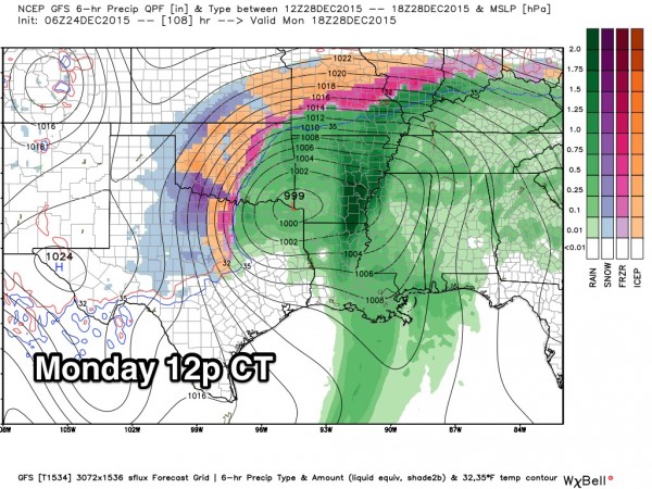
It is too early to determine the overall threat of severe thunderstorms here in Alabama, but no doubt it will be a possibility. And, back in the cold sector, this storm system will drop a huge amount of snow (10-20 inches) on parts of West Texas and Oklahoma. Traveler beware.
Cooler and drier air returns to Alabama by mid-week. See the Weather Xtreme video for maps, graphics, and more details.
BIRMINGHAM BOWL: Auburn will take on Memphis at Legion Field next Wednesday; kickoff is at 11:00 a.m. At this point the weather looks good; the sky mostly cloudy but only a small risk of a shower. Temperatures will rise from near 50 at kickoff, into the mid 50s by the final whistle.
AT THE BEACH: Warm, showery weather is the story through Sunday on the coast from Gulf Shores over to Panama City Beach; storms are likely Monday. See the complete Gulf Coast 7 Day Planner here. The Gulf Coast Beach Forecast is presented by Gulf Shores Plantation by Mandoki Hospitality Vacation Rentals. Escape to Gulf Shores Plantation where memories last a lifetime.
WEATHER BRAINS: Don’t forget you can listen to our weekly 90 minute netcast anytime on the web, or on iTunes. This is the show all about weather featuring many familiar voices, including our meteorologists here at ABC 33/40.
CONNECT: You can find me on all of the major social networks…
Facebook
Twitter
Google Plus
Instagram
We are on a holiday schedule, so just one Weather Xtreme video per day through the weekend, but we will post updates through the day. I hope you and your family enjoy God’s richest blessings at this time of the year, and Merry Christmas!
Category: Alabama's Weather
About the Author (Author Profile)
James Spann is one of the most recognized and trusted television meteorologists in the industry. He holds the AMS CCM designation and television seals from the AMS and NWA. He is a past winner of the Broadcast Meteorologist of the Year from both professional organizations.Subscribe
If you enjoyed this article, subscribe to receive more just like it.


