

Major Flooding Event in Southeast Alabama
A major flooding event is in progress across Southeast and South Alabama.
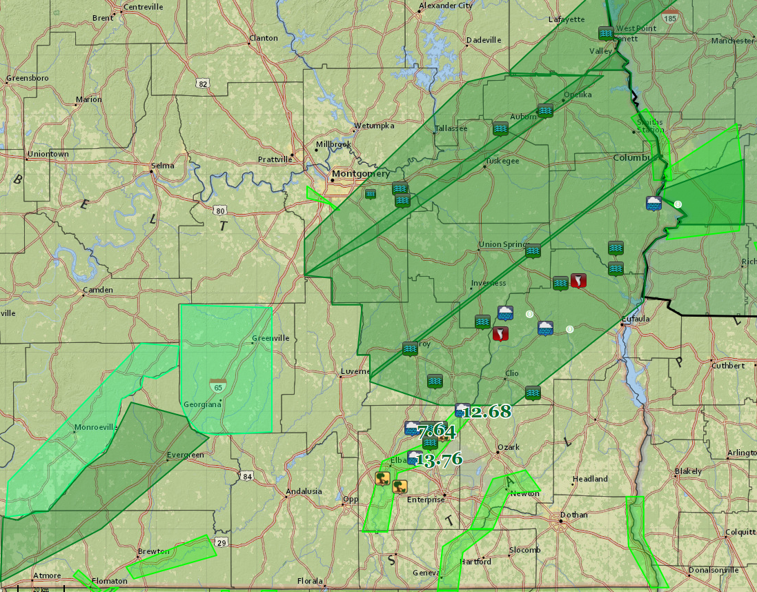
Click image to enlarge.
UPDATE AT 12:08:
CIVIL EMERGENCY MESSAGE
ALABAMA EMERGENCY MANAGEMENT AGENCY
RELAYED BY NATIONAL WEATHER SERVICE BIRMINGHAM AL
1205 PM CST THU DEC 24 2015
THE FOLLOWING MESSAGE IS TRANSMITTED AT THE REQUEST OF THE
ALABAMA EMERGENCY MANAGEMENT AGENCY.
THE BARBOUR…CHAMBERS…MACON…AND PIKE COUNTY EMERGENCY
MANAGEMENT AGENCY AND LAW ENFORCEMENT OFFICIALS ARE REQUESTING
THAT ALL COUNTY RESIDENTS REMAIN OFF ROADWAYS UNLESS IT IS AN
EMERGENCY DUE TO THE WIDESPREAD FLOODING. ALL ROADS SHOULD BE
LEFT OPEN TO EMERGENCY RESPONDERS ONLY. THE REQUEST GOES THROUGH
NOON ON DECEMBER 25.
LATE REPORT: Flash flood warning extended to 1 p.m. for Elmore, Lee, Macon, Montgomery and Tallapoosa Counties.
LATE REPORT AT 11:33: Severe flooding in Auburn near East Glen Ave. Several roads between AL-14 and Shug Jordan Pkwy and Wills Turk Road are closed.
The graphic shows current flash flood warnings in dark green, and areal flood advisories in lighter green with river flood warnings in the narrower strips of green. Storm reports are also displayed, including 3 day total rainfall amounts, flooding reports, a couple of tornado touchdowns and some wind damage reports.
Speaking of wind damage, we just received a report of brown winds of downed trees 2 miles east of Opelike in Lee County at 10:27 a.m. Windswer e estimated to be 60 mph.
Flash flood warnings cover most of counties, including Chambers, Lee, Tallapoosa, Elmore, Montgomery, Macon, Russell, Bullock, Pike and Barbour in Southeast Alabama and Conecuh and Escambia in South Alabama.
As much as 5-10 inches of rain has fallen over the past couple of days over South Alabama in about a 60 mile wide swath from Mobile and Washington up through Monroe and Escambia to Montgomery and Crenshaw to Lee and Barbour Counties.
Places like Mobile Jackson, Monroeville, Flomaton, Georgiana, Greenville, Luverne, Clayton and Union Springs have picked up the heavier amounts.
And more rain is falling at this hour across the flash flood warned counties.
The heaviest rain at 11:30 was over Monroe, Conecuh, Butler and Coffee Counties. The storms between Evergreen, Greenville and Monroeville are producing rainfall rates in excess of 1.5 inches per hour and copious amounts of lightning as well.
…Street flooding was reported in Auburn around 10:40. Flash flood warning (FFW) until noon for Auburn.
…Several reports of flooding East Montgomery, around Vaughn Road.
…Highway 29 was impassable in Lanett. It is also impassable at the AL/GA line near Lanett. Traffic is being re-routed.
…Highway 82 was closed at the County Line between Pike and Barbour and traffic was being rerouted.
…Water was flowing across the bridge on CR-49 near Comer.
…Water covering bridge on Highway 239 near CR 27 near Pickett.
…Sinkhole on AL-20 just across the Pike/Bullock County Line near Boot Hill. Traffic being rerouted.
…Several roads are flooded and closed in Pike County near Brundidge. AL-93 closed near MP 3. Traffic being re-routed.
…County road 223 flooded in Pike County near Inverness and impassable.
LATE INFORMATION
…Blue Spring State Park in Barbour County has been closed due to flooding.
But the big amounts have come from Coffee and Dale Counties:
…13.76 inches over 3 days near New Brockton in Coffee County
…12.68 inches over 3 days near Ariton in Dale County
Of course, if you are familiar with this area, you now this is the watershed for the Pea River, which has produced some epic flooding at Elba in Coffee County. Flood warnings continue for the Pea River. The Pea will rise to 39.9 feet by the afternoon on Christmas Day (flood stage is 30 feet). Significant flooding begins at 41 feet with AL-87 becoming inundated and the SCL railroad bridge going under water. Many roads are closed or washed out especially over northeast Coffee County.
…Trees were also reported down across Coffee County around midnight last night.
At Flomaton in Escambia County, the Big Escambia Creek is expected to crest at 16.9 feet, which will cause moderate flooding. Highway 31 begins to flood at 16 feet.
In addition to all that, there has been some severe weather including several severe thunderstorm warnings. There was even a radar confirmed tornado (tornado debris signature) near Spring Hill in Barbour County around 3:45 a.m. with another around Boot Hill around 4:30. Those locations are between Troy and Eufaula
Category: Alabama's Weather, Severe Weather
About the Author (Author Profile)
Bill Murray is the President of The Weather Factory. He is the site's official weather historian and a weekend forecaster. He also anchors the site's severe weather coverage. Bill Murray is the proud holder of National Weather Association Digital Seal #0001 @wxhistorianSubscribe
If you enjoyed this article, subscribe to receive more just like it.


