

Rain Returns Thursday Night
FRIGID WINTER MORNING: Coldest spot I can find this morning is Russellville, in Franklin County, with 19 degrees. Other colder pockets are in the low 20s; Cullman and Haleyville report 22 just before sunrise. The sky is clear, and the wind is light.
Today will be another sunny but very cool day; most communities will see a high in the upper 40s this afternoon. FYI, the average high for Birmingham for January 5 is 53.
The weather stays dry tomorrow with a partly sunny and a high in the lower 50s.
NEXT RAIN: The sky becomes cloudy Thursday, and the next wave in the southern branch of the jet stream will bring rain to the state late Thursday afternoon and Thursday night; seems like the main window for rain will come from 4:00 p.m. Thursday to 4:00 a.m. Friday. Rain amounts will be 1/2 inch or less, and this time we won’t have any severe weather, probably no thunder, and certainly no flooding.
The day Friday looks generally dry, but the clouds will linger. We reach the low 60s Friday afternoon for a comfortable mid-winter day.
THE ALABAMA WEEKEND: The next wave will bring more rain to the state. Global models are now in agreement on a faster solution, suggesting rain is likely Saturday statewide. Again, no severe weather and no flooding problems, but expect periods of rain throughout the day with an afternoon high in the low 60s. The rain will end Saturday night, and Sunday looks mostly cloudy and colder with a high back in the 40s.
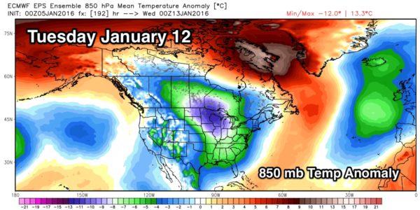
MORE COLD AIR: A cold pattern is setting up for the eastern half of the U.S. next week, as both the Arctic Oscillation (AO) and North Atlantic Oscillation) stay negative. Most computer model output is showing highs in the 40s and lows in the 20s around here, but I do believe there could be a day or two with highs in the 30s and lows in the teens, based on the pattern.
For now the cold snap next week looks generally dry, but I assure you computer models won’t handle this pattern very well a week in advance. We will just have to be vigilant for waves that come through the southern edge of the cold air; the 06Z GFS does show some potential for light rain over far South Alabama Tuesday, but the European (ECMWF) shows nothing. Every run will look different, we will just watch for trends. But, the main message is that next week looks cold, most likely the coldest air we have seen so far this winter. See the Weather Xtreme video for maps, graphics, and more details.
FOOTBALL WEATHER: Saturday, Jacksonville State plays North Dakota State for the FCS National Championship Saturday in Frisco, Texas (north of Dallas; 11:00a CT kickoff). There will be cloudy periods during the game, but for now it looks like a small risk of a shower. Temperatures will rise from 44 degrees at kickoff, to near 47 by the final whistle.
The FBS National Championship game, Alabama vs Clemson, is Monday at Glendale, Arizona (7:30p CT kickoff). Despite a good bit of rain for Phoenix this week, the weather looks cool and dry for the game with temperatures falling from the low 50s at kickoff, into the upper 40s by the second half.
WEATHER BRAINS: Don’t forget you can listen to our weekly 90 minute netcast anytime on the web, or on iTunes. This is the show all about weather featuring many familiar voices, including our meteorologists here at ABC 33/40. Scroll down for the show notes on the new episode we recorded last night.
CONNECT: You can find me on all of the major social networks…
Facebook
Twitter
Google Plus
Instagram
Look for the next Weather Xtreme video here by 4:00 this afternoon… enjoy the day!
Category: Alabama's Weather
About the Author (Author Profile)
James Spann is one of the most recognized and trusted television meteorologists in the industry. He holds the AMS CCM designation and television seals from the AMS and NWA. He is a past winner of the Broadcast Meteorologist of the Year from both professional organizations.Subscribe
If you enjoyed this article, subscribe to receive more just like it.


