

Wet Today; Cold Sunday
Latest radar image composite across the Southeast US shows rain pushing east into Alabama as a surface low over the Lower Mississippi River Valley pushes northeastward into the eastern Great Lakes. This will result in a rather wet day for much of Alabama with temperatures remaining somewhat mild as highs reach the 57 to 61 range. Some spots, especially in Northwest Alabama, could hear some thunder with the extreme northwest corner of Alabama and much of the northern two thirds of Mississippi within a marginal risk area defined by SPC. As this system pushes east later today and tonight, the instability values will come down as we begin to focus on the arrival of some pretty cold air.

In fact, it looks like we will see some of the coldest air of this winter season arrive Sunday and Monday. Temperatures across Alabama will plummet into the 30s behind the front as the front barrels through the state tonight and early Sunday. By the time to wake up on Sunday morning temperatures will be in the 30s. And Sunday is likely to be a rather raw day with clouds sticking around, a stiff northwest wind at 12 to 17 mph, and the afternoon highs struggling to get out of the 30s for many spots. The Sunday afternoon highs should be in the 38 to 41 range. Sounds crazy to call the lower 40s warm, isn’t it?
The upper trough that will help to usher in the cold air tonight and Sunday will remain in place over the eastern half of the country through Wednesday. This means morning lows in the 20s and afternoon highs in the 40s for the first half of the week.
And then the forecast really gets interesting and challenging. The interest and challenge come from the difference in how the two major long range models handle the next system. They do agree on the overall scenario, but the placement of the features is different, so there is a good deal of uncertainty in the forecast for the latter half of the week.
Wednesday into Thursday a fairly strong short wave trough will eject from the Southwest US into the northern Gulf. This sets up the situation of cold air at the surface with warmer, moist air coming out of the Southwest US. The GFS tracks the trough further south than the ECMWF with a surface low developing in the Central Gulf of Mexico. Since the ECMWF does not take the upper trough as far south, that model develops a surface low just off the Central Gulf Coast tracking it eastward across North Florida into the Southwest Atlantic. These two solutions result in very different weather forecasts for North and Central Alabama. The GFS presents a cold rain scenario while the ECMWF forecast presents a snow event for Central and North Alabama (see graphic).
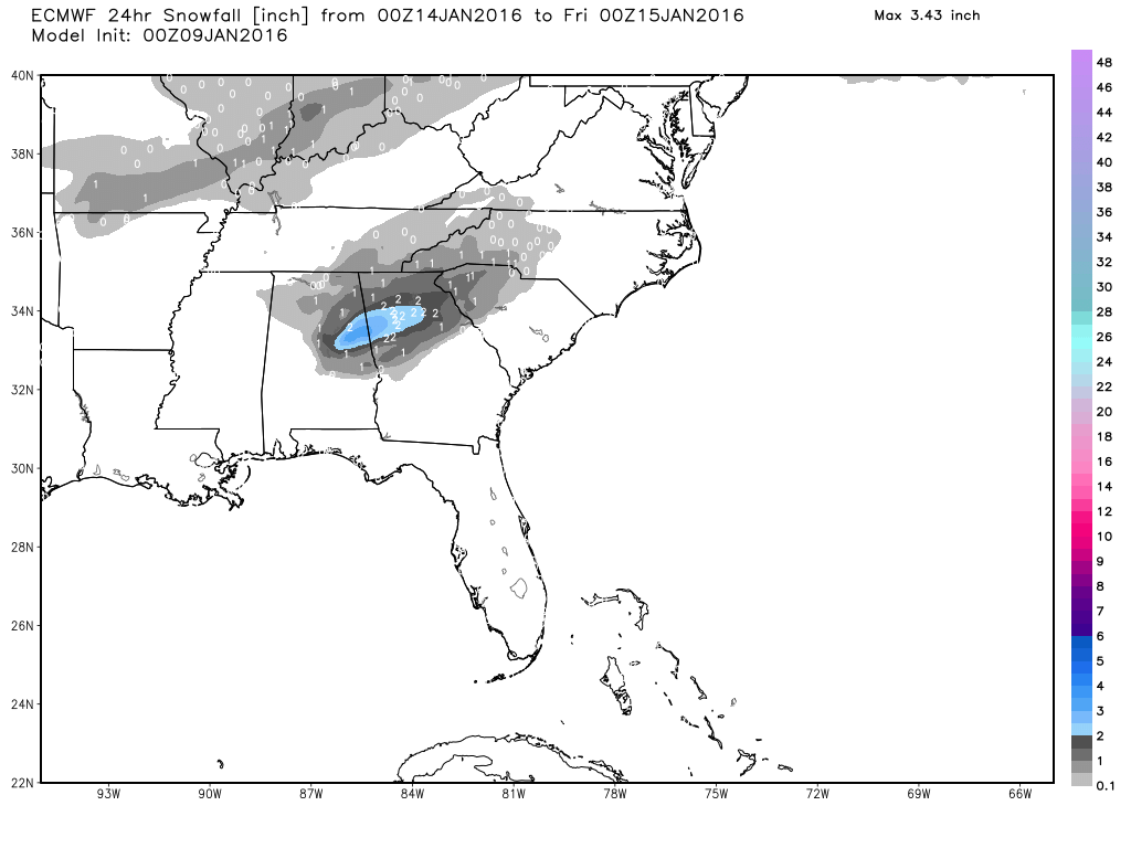
Faced with the uncertainty in the two models, the best course of action is to keep a chance of rain in the forecast. The presence of a potential snow event in one model from one run five days out is NOT cause to start drastic action like changing travel plans and closing schools or businesses. This is the kind of situation where we carefully watch how future model runs handle this situation and take steps to adjust the forecast if necessary. So this definitely qualifies as a “stay tuned” situation.
The strong upper trough moves off into the Atlantic on Friday with another one coming into the Central Plains by Friday afternoon. We should see a dry day on Friday with temperatures pretty close to seasonal values with lows in the lower 30s and highs in the lower 50s.
A new upper trough digs into West Texas on Saturday which could bring another round of precipitation to Alabama on Sunday the 17th.
Big football games today and Monday. Jacksonville State plays North Dakota State for the FCS National Championship today in Frisco, TX, north of Dallas with an 11:00 am kickoff. Expect a mix of sun and clouds; just a small risk of light rain or a snow shower this morning. Temperatures will be on the chilly side with temperatures in the lower 40s falling into the 30s during the game.
The FBS National Championship game, Alabama vs Clemson, is Monday at Glendale, AZ, with a 7:30 pm kickoff. Despite a good bit of rain for Phoenix this week, the weather looks cool and dry for the game with temperatures falling from the mid 50s at kickoff into the upper 40s by the second half. The stadium has a roof, but it will be pretty chilly walking to and from your transportation.
The screaming message from the forecast maps in voodoo country is that we are going to remain in an active pattern. After the system goes by on Sunday, the 17th, it will be followed by another one around the 22nd. And by the end of the period, the overall pattern sticks with a chilly look with a sizable trough along the East Coast of the US.
I’ll be filling in for Meaghan Thomas this weekend, so you can catch the latest forecast at 6 and 10 pm this evening on ABC 3340. I plan to post the next Weather Xtreme Video here by 8 am or so on Sunday morning. Enjoy the day, stay dry, and get ready for some chilly weather. Godspeed.
-Brian-
Category: Alabama's Weather
About the Author (Author Profile)
Brian Peters is one of the television meteorologists at ABC3340 in Birmingham and a retired NWS Warning Coordination Meteorologist. He handles the weekend Weather Xtreme Videos and forecast discussion and is the Webmaster for the popular WeatherBrains podcast.Subscribe
If you enjoyed this article, subscribe to receive more just like it.


