

Dry and Pleasant Tomorrow; Rain Friday
SUNNY WINTER DAY: Temperatures are actually a little above forecast levels this afternoon, and nobody seems to be griping. We projected a high between 47 and 50; most Central Alabama communities are in the low to mid 50s with a good supply of sunshine. Readings are in the 40s over the northern third of the state.
Tonight won’t be as cold as recent nights; most communities will see a low in the mid 30s, but colder pockets will see a light freeze early tomorrow.
Tomorrow should be the warmest day of the week with a high close to 60 degrees, with lots of sunshine through scattered clouds.
NEXT RAIN: Rain will push into Alabama after midnight tomorrow night, and we will continue to forecast periods of rain Friday as a surface low passes to the south. Rain amounts should be 1/2 inch or less, and you probably won’t hear any thunder with no real surface based instability. The high Friday will be in the low to mid 50s.
WEEKEND MODEL MADNESS: As noted on the post below this one, forecast confidence is a bit lower than usual due to the stubborn GFS model. It remains an outlier this afternoon; the 12Z run shows a deepening surface low moving from near Pensacola to the Outer Banks of North Carolina over the weekend, with rain for much of Alabama Saturday night, and snow for the northern-most counties. That rain-snow line moves southward during the pre-dawn hours Sunday as cold air is pulled southward on the back side of the surface low.
But, not so fast… there is no support for this solution from any other model in the house, including the reliable European (ECMWF), the Canadian (GEM), and the North American Mesoscale (NAM). All three of these models are showing no precipitation and no Gulf coast low, and the air over Alabama will be pretty dry, and we continue to reject the GFS solution in our public forecast package this afternoon. Meaning, for now we are forecasting a generally dry weekend. Saturday will be mostly cloudy with a high in the low 50s, but Sunday should be colder with a high in the 40s along with a mix of sun and clouds.
NEXT WEEK: Cold air settles in here early in the week; many North Alabama communities won’t get out of the 30s Monday afternoon, and the low around here early Tuesday will be close to 20 degrees. Then, expect a slow warming trend through mid-week, and rain returns by Thursday and Thursday night with a surface low passing northwest of Alabama. See the Weather Xtreme video for maps, graphics, and more details.
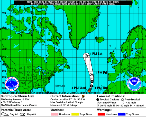
RARE JANUARY TROPICAL SYSTEM: Sub-tropical Storm Alex has formed in the eastern Atlantic… no threat to land, but it is way out of season. It is the second tropical storm to form in January in the Atlantic basin since 1851.
WEATHER BRAINS: Don’t forget you can listen to our weekly 90 minute netcast anytime on the web, or on iTunes. This is the show all about weather featuring many familiar voices, including our meteorologists here at ABC 33/40.
CONNECT: You can find me on all of the major social networks…
Facebook
Twitter
Google Plus
Instagram
I had a great time today visiting students from Ashville and Steele Elementary Schools, gathered together at the Eden Career Tech Center in Ashville, and also great to see the first graders at Crestline Elementary in Mountain Brook. Be looking for them on the Pepsi KIDCAM today at 5:00 and 6:00 on ABC 33/40 News! The next Weather Xtreme video will be posted here by 7:00 a.m. tomorrow…
Category: Alabama's Weather
About the Author (Author Profile)
James Spann is one of the most recognized and trusted television meteorologists in the industry. He holds the AMS CCM designation and television seals from the AMS and NWA. He is a past winner of the Broadcast Meteorologist of the Year from both professional organizations.Subscribe
If you enjoyed this article, subscribe to receive more just like it.


