

Rain Tomorrow; Colder Air Arrives Sunday
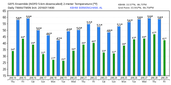
THIS MORNING: There is a big spread in temperature across Alabama this morning; Vic Bell at Black Creek reports 21 degrees, but Cullman is above freezing just before daybreak with 36. But we will all warm up nicely today with a high close to 60 degrees this afternoon along with a good supply of sunshine through scattered clouds. This will be the warmest day of the week.
Clouds move in quickly tonight, and we might even see some light rain in spots after midnight.
TOMORROW: We will forecast periods of mostly light rain across North/Central Alabama, with potential for heavier rain and a few thunderstorms near the Gulf Coast. No severe weather issues, and rain for the northern half of the state will be under 1/2 inch. And, it won’t rain all day. Expect a high in the 50s.
THE ALABAMA WEEKEND: Saturday will be mostly cloudy, but dry with a high in the low to mid 50s. Another surface wave forms in the Gulf of Mexico, and that feature will spread some rain into far South Alabama Saturday night. Almost all guidance shows no precipitation for North Alabama, and the GFS continues to back off it’s idea of accumulating snow (it has been an outlier all along, and it’s solution was rejected). We will mention just a few sprinkles or flurries Saturday night across North Alabama, but in a dry airmass most communities will be dry.
Sunday will be dry and colder, with a few intervals of sunshine and a high in the mid 40s.
NEXT WEEK: Even colder air settles into the state Monday; most of North Alabama won’t get out of the 30s, and some places up in the Tennessee Valley could stay below freezing much of the day despite a decent amount of sunshine. We drop well down into the 20s early Tuesday, and colder pockets will visit the teens. Then, a warming trend begins Tuesday afternoon.
Some light rain could break out Wednesday, with rain more likely Thursday as a surface low moves through the state. See the Weather Xtreme video for maps, graphics, and more details. No sign of any “winter storms” or other high impact events here for the next 7-10 days.
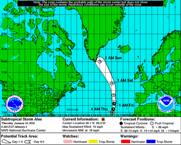
JANUARY TROPICAL ACTION: Sub-tropical Storm Alex is in the far eastern Atlantic, moving northward. No threat to land… last time we had a named system in January was in 1978. Hurricane season for the Atlantic basin runs from June 1 through the end of November, so this one is way out of season.
WEATHER BRAINS: Don’t forget you can listen to our weekly 90 minute netcast anytime on the web, or on iTunes. This is the show all about weather featuring many familiar voices, including our meteorologists here at ABC 33/40.
CONNECT: You can find me on all of the major social networks…
Facebook
Twitter
Google Plus
Instagram
I have a weather program today at South Shades Crest Elementary in Hoover… look for the next Weather Xtreme video here by 4:00 this afternoon. Enjoy the day!
Category: Alabama's Weather
About the Author (Author Profile)
James Spann is one of the most recognized and trusted television meteorologists in the industry. He holds the AMS CCM designation and television seals from the AMS and NWA. He is a past winner of the Broadcast Meteorologist of the Year from both professional organizations.Subscribe
If you enjoyed this article, subscribe to receive more just like it.


