

Very Cold Day For Alabama
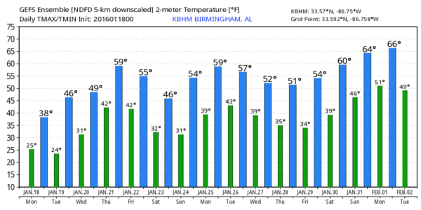
FRIGID AIR: We are starting the day with sub-freezing temperatures over about the northern half of the state, and unfortunately these values won’t be changing much during the day, despite a decent amount of sun. Most of the Tennessee Valley of far North Alabama will stay below freezing all day, and places like Birmingham, Tuscaloosa, Anniston, and Gadsden will see a high only in the 35-39 degree range.
A few snow flurries have moved into Northwest Alabama, but they won’t last long, and there won’t be any impact.
HARD FREEZE TONIGHT: We project a low between 15 and 19 degrees for most places early tomorrow, and close to 10 for the coldest valleys across North Alabama. This will be the coldest night so far this winter for most of the state, and you will want to bring in the pets. Places like Huntsville will be below freezing for about 35 consecutive hours (from late last night through mid-morning tomorrow).
Up until now Birmingham’s coldest morning was back on January 11, when the low was 20.
TOMORROW: We warm into the low tomorrow afternoon with a good supply of sunshine. Clouds will begin to increase tomorrow night.
FREEZING RAIN FOR FAR NORTH ALABAMA WEDNESDAY MORNING? This will be a close call. Light rain will move into Alabama Wednesday morning, and if the precipitation begins early enough, it will be in the form of light freezing rain over the Tennessee Valley of extreme North Alabama. For travelers, confidence is much higher of ice forming on roads over Tennessee; roads around Nashville should be very icy Wednesday morning with freezing rain falling. Hopefully the rain begins late enough in the day that ice won’t be an issue for North Alabama, but just be aware of the possibility.
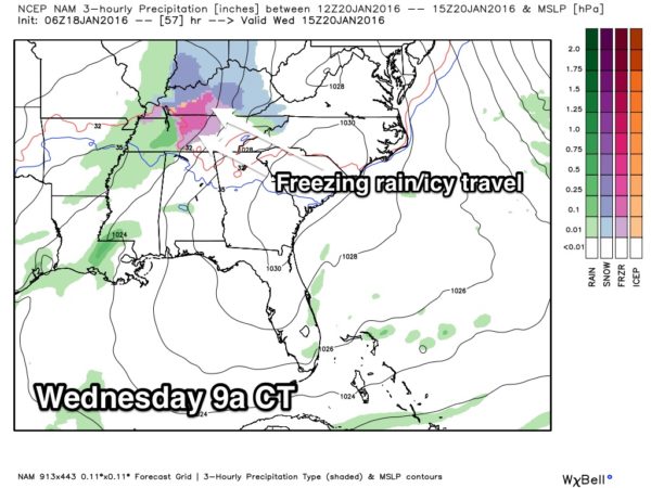
For Birmingham/Tuscaloosa/Anniston/Gadsden, no ice is expected; just some light rain Wednesday; temperatures should rise to near 50 degrees by afternoon as the slow warm-up continues.
THURSDAY/FRIDAY: A more significant storm will impact Alabama. A surface low should move from near Shreveport to Northwest Alabama, and will bring a soaking rain to the state Thursday and Thursday night. A few thunderstorms could be involved, but no severe weather is expected. Rain amounts of around one inch are likely, and the high will be near 60 degrees.
Then, on Friday, the low will move to near Asheville, NC, and as cold air spills in behind the low there is a chance the rain could change to light snow or snow flurries over parts of North Alabama with temperatures falling during the day. If that happens, for now we don’t expect any impact and no accumulation.
TO THE NORTHEAST: This storm system will bring potential for a major snow event from North Carolina to New England Friday through Saturday. Both the European and American global models show a high impact winter storm that could disrupt travel and bring some amounts over two feet in spots. If you are traveling to Washington, Baltimore, Philadelphia, New York City, or Boston late this week or over the weekend, this system will make that travel very challenging, if not impossible. A little too early to be really specific, but just be aware of the potential.
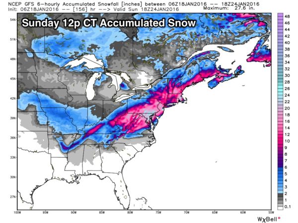
Note… you see some grey on that map over Alabama; understand we do not expect accumulating snow here Friday.
THE ALABAMA WEEKEND: A warming trend headlines the forecast, the sky should be mostly sunny Saturday and Sunday. We reach the mid 40s Saturday, and mid 50s Sunday.
Some patchy light rain could reach the state early next week… see the Weather Xtreme video for maps, graphics, and more details.
WEATHER BRAINS: Don’t forget you can listen to our weekly 90 minute netcast anytime on the web, or on iTunes. This is the show all about weather featuring many familiar voices, including our meteorologists here at ABC 33/40. We will produce this week’s show tonight at 8:30 CT… you can watch it here.
CONNECT: You can find me on all of the major social networks…
Facebook
Twitter
Google Plus
Instagram
Look for the next Weather Xtreme video here by 4:00 this afternoon… enjoy the day!
Category: Alabama's Weather
About the Author (Author Profile)
James Spann is one of the most recognized and trusted television meteorologists in the industry. He holds the AMS CCM designation and television seals from the AMS and NWA. He is a past winner of the Broadcast Meteorologist of the Year from both professional organizations.Subscribe
If you enjoyed this article, subscribe to receive more just like it.


