

Strong Storms, Colder, Some Snow
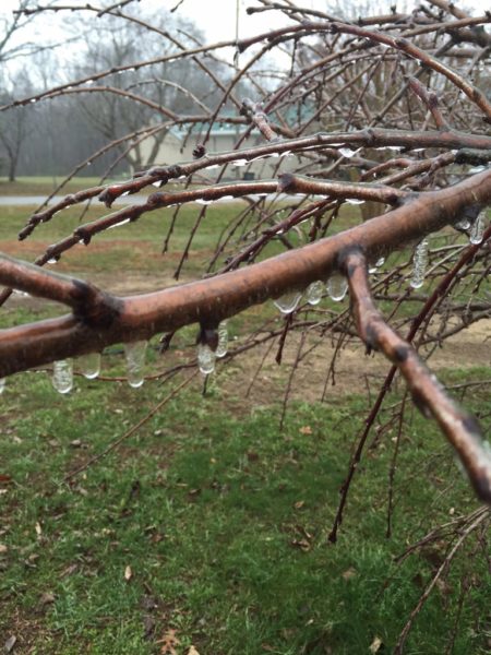
VERY ACTIVE WEATHER: Rain is still falling this afternoon across parts of Central Alabama, mainly south of I-20. Otherwise, it is a cloudy and cold day. Temperatures are barely above freezing across Northeast Alabama, where some light icing has been reported. Photo below is from Lookout Mountain near Fort Payne… via @rolltide23
The sky will stay cloudy tonight, with some patchy light rain possible.
We have two issues we will focus on this afternoon….
SEVERE WEATHER THREAT TOMORROW AFTERNOON/TOMORROW NIGHT: SPC has adjusted the “Day Two” convective outlook, and the standard “slight risk” of severe storms now extends northward to Tuscaloosa, with a “marginal” risk to Birmingham…
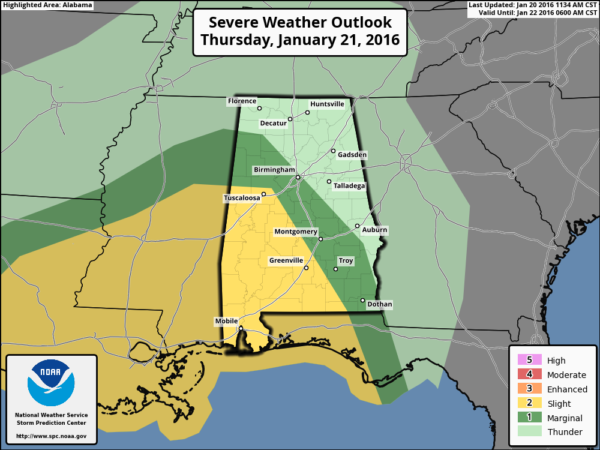
The primary threat of severe storms will come from about 4:00 p.m. tomorrow to midnight tomorrow night. The main risk will come from hail and strong, perhaps damaging straight line winds, but an isolated tornado can’t be completely ruled out. Higher tornado probabilities exist to the west over South Mississippi.
This is a very dynamic weather system, and we will watch radar trends very closely tomorrow afternoon and tomorrow night. Rain amounts of around 1 inch are likely.
A RISK OF SNOW FRIDAY AND FRIDAY NIGHT: As the surface low pulls northeast, away from Alabama, much colder air will drop into the state Friday with a gusty north wind. We start the day in the 50s at daybreak, then we fall through the 40s during the midday hours, reaching the 30s by mid to late afternoon.
Lingering light rain on the back side of the departing low will turn to light snow; the change will initially happen over Northwest Alabama, and it could happen as early as 12:00 noon near the Mississippi border across counties like Lamar, Marion, Franklin, Colbert, and Lauderdale. This is where some communities could see over 1 inch of snow; to the west most of North Mississippi is under a winter storm watch, where 4 inches of snow is possible.
For most of North/Central Alabama, the change from rain to snow will come between 3:00 and 6:00 p.m. And, temperatures won’t drop below freezing until after 6:00, so we do not expect any travel impact during the day Friday, with the possible exception of far Northwest Alabama (Lamar, Marion, Franklin, Colbert, and Lauderdale Counties).
Light snow/snow flurries will continue Friday night, and some light accumulation is possible as far south as I-20. We will project amounts under 1 inch, probably closer to 1/4 inch, for places like Birmingham, Tuscaloosa, and Anniston. The European model seems to have a good grasp on this potential…
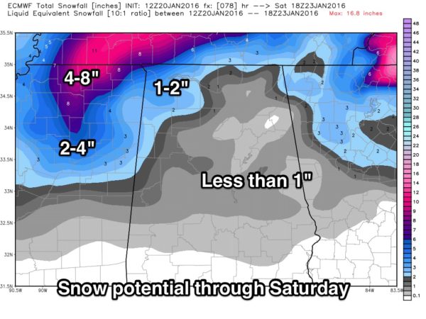
There could be a few slick/icy spots Friday night and Saturday morning due to light snow and sub freezing temperatures over the northern half of Alabama, especially along and north of I-20. While I don’t think this will be an especially high impact event, anyone that needs to travel Friday night needs to be aware of the potential for some ice/snow issues.
As is the case with any winter weather situation, please keep up with the latest blog posts for forecast changes…
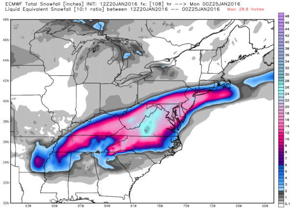
MAJOR EAST COAST SNOW STORM: A blizzard watch is in effect for Washington D.C. for Friday/Saturday; still looks like some spots across KY/WV/VA/MD will see two feet of snow from this blockbuster system. The snow will ultimately impact larger cities like Baltimore, Philadelphia, New York City, and Boston. Travel around Washington and Baltimore will become difficult, if not impossible Friday and Saturday. Expect major airport delays across the eastern third of the U.S.
THE ALABAMA WEEKEND: Saturday will be breezy and cold with a mix of sun and clouds along with a risk of morning snow flurries; we won’t get out of the 30s. Then, on Sunday, after a low down in the low 20s, we rise to near 50 degrees with a good supply of sunshine.
NEXT WEEK: Some light rain will return Monday night and Tuesday thanks to an approaching cold front, and we see evidence of a warmer period toward the end of January and the first of February. See the Weather Xtreme video for maps, graphics, and more details.
WEATHER BRAINS: Don’t forget you can listen to our weekly 90 minute netcast anytime on the web, or on iTunes. This is the show all about weather featuring many familiar voices, including our meteorologists here at ABC 33/40.
CONNECT: You can find me on all of the major social networks…
Facebook
Twitter
Google Plus
Instagram
I had a great time today visiting with the 2nd graders at Bluff Park Elementary School in Hoover… be looking for them on the Pepsi KIDCAM today at 5:00 on ABC 33/40 News! The next Weather Xtreme video will be posted here by 7:00 a.m….
Category: Alabama's Weather
About the Author (Author Profile)
James Spann is one of the most recognized and trusted television meteorologists in the industry. He holds the AMS CCM designation and television seals from the AMS and NWA. He is a past winner of the Broadcast Meteorologist of the Year from both professional organizations.Subscribe
If you enjoyed this article, subscribe to receive more just like it.


