

Storms, Colder, Then Some Snow
MUCH TO DISCUSS: We will be very busy in the weather office over the next 48 hours as a very robust weather system swings through the eastern half of the nation.
TODAY: A surface low, the initiation of what promises to be a blockbuster eastern U.S. snow storm, forms over Texas north of Houston, with a warm front extending eastward along the Gulf Coast. That warm front will lift slowly northward, and we will mention a chance of showers during the day. Temperatures rise into the 50s this afternoon.
SEVERE WEATHER RISK TONIGHT: The surface low moves northeast into Mississippi… and the guys at SPC have defined an “enhanced” severe weather threat for Southwest Alabama tonight, with the standard “slight risk” up into Sumter, Greene, and Hale Counties of West Alabama.
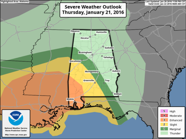
PLACEMENT: It sure seems like the best combination of instability and shear will be over Southwest Alabama tonight. I would suggest the main severe weather threat will come in the broad area from Demopolis to Mobile, with a much smaller risk as far north as Tuscaloosa. The risk of severe weather for Birmingham, Anniston, and Gadsden is very low tonight as the air there will be stable.
TIMING: The core severe weather threat will come from about 9:00 p.m. through 6:00 a.m.
MODES: While strong straight line winds and hail are the main threats, we sure can’t rule out a tornado or two, especially over far Southwest Alabama (closer to Mobile).
RAIN AMOUNTS: Rain totals of at least one inch are likely tonight, with isolated amounts approaching two inches. I don’t think it will be enough for flooding issues.
COLD AIR RETURNS TOMORROW: Temperatures will be going the wrong way. We will be in the 50s around sunrise, but after that we fall through the 40s, reaching the 30s by late afternoon with a gusty northwest wind. Periods of rain will continue through the day as the cold air rolls in.
SNOW TOMORROW NIGHT: As cold air deepens, the rain will change over to light snow across the northern half of Alabama on the back side of the departing surface low.
TIMING: The change will begin over the far northwest counties in the 3-6 p.m. time frame, but for most of the state snow won’t begin until after 6:00 p.m. It might be after 10:00 p.m. before you see snow flakes over East Alabama.
AMOUNTS: All guidance continues to suggest any accumulation will be pretty light across our state. Best chance of seeing an inch of snow will be over the Tennessee Valley of far North Alabama, and over the eastern counties.
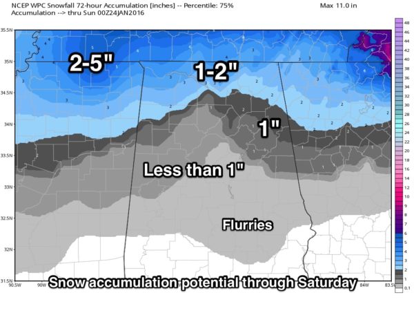
Understand we will be dealing with convective type snow showers tomorrow night, and distribution won’t be especially even. But, generally speaking, amounts across North/Central Alabama will be under one inch, and in some cases, no accumulation at all.
IMPACT: Temperatures are expected to generally remain above freezing through midnight tomorrow night, so for now we expect no impact from the light snow during the day tomorrow, or early tomorrow night. But, after midnight tomorrow night into Saturday morning, temperatures will drop to near freezing, and there could be a few icy patches. Due to strong wind and the light nature of the snow, the overall travel impact in Alabama looks relatively low for now. But again, if you are driving early Saturday morning be aware of the potential for a few slick spots.
REMEBER: This forecast can, and probably will change, so check the blog often for updates and revisions.
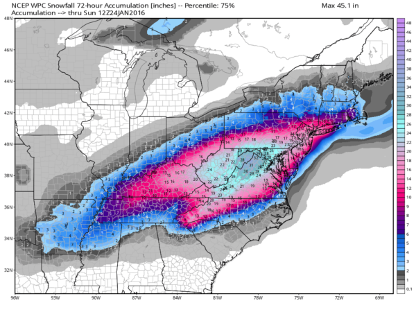
TO THE NORTHEAST: Parts of WV/VA/MD will be buried; some spots will see two feet of snow, and blizzard conditions are likely around Washington and Baltimore tomorrow night into Saturday. Travel in the core of the storm will become difficult, if not impossible. The snow will also impact cities like Philadelphia, New York City, and Boston.
THE ALABAMA WEEKEND: Saturday will be cold and breezy with a mix of sun and clouds and a risk of lingering morning snow flurries; we won’t get out of the 30s. Then, on Sunday, after starting the day in the low 20s we rise to near 50 degrees with a good supply of sunshine.
NEXT WEEK: A cold front will bring a chance of showers Tuesday, followed by cooler air Wednesday. No sign of any winter weather mischief for now… see the Weather Xtreme video for maps, graphics, and more details.
WEATHER BRAINS: Don’t forget you can listen to our weekly 90 minute netcast anytime on the web, or on iTunes. This is the show all about weather featuring many familiar voices, including our meteorologists here at ABC 33/40.
CONNECT: You can find me on all of the major social networks…
Facebook
Twitter
Google Plus
Instagram
I have a weather program this morning at Floyd Elementary in Gadsden… look for the next Weather Xtreme video here by 4:00 this afternoon. Enjoy the day!
Category: Alabama's Weather
About the Author (Author Profile)
James Spann is one of the most recognized and trusted television meteorologists in the industry. He holds the AMS CCM designation and television seals from the AMS and NWA. He is a past winner of the Broadcast Meteorologist of the Year from both professional organizations.Subscribe
If you enjoyed this article, subscribe to receive more just like it.


