

Early Afternoon Notes
Thunderstorms (non-surface based) are moving over north-west Alabama at this hour. They are not severe, but do have some small hail and lightning. Some light rain extends from Bibb County up through Shelby County.
The surface low that will become our historic East Coast storm has formed northwest of Houston. Showers and thunderstorms are occurring across eastern Texas and western Louisiana. A tornado watch is in effect for much of Louisiana and eastern Texas. There are two tornado warnings for areas southeast of Lufkin and a couple of severe thunderstorm warnings as well. CAPE values are approaching 2000 joules in that area and wind shear values are very high as well. Temperatures are in the middle and upper 70s in the Houston area with dewpoints in the middle and upper 60s.
The SPC has an enhanced severe weather risk from Houston to Jackson to Mobile, including areas from Choctaw through Clarke and Monroe Counties on south to the coast. A slight risk extends up to Greene, Hale and Perry Counties, or just south of Tuscaloosa. The best chances for severe weather tonight will be over Southwest Alabama.
Rainfall amounts will be significant tonight, with widespread 1 to 2 inch amounts across Central Alabama.
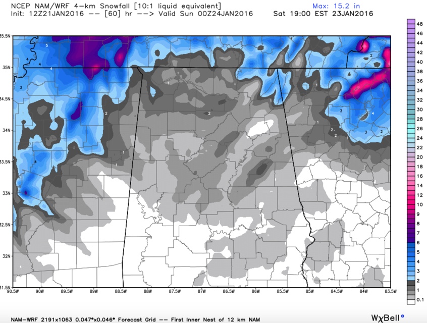
Winter storm watches and warnings cover areas all around Alabama, but not in our state, at least yet. The best chances for snowfall will be to our northwest in the deformation zone around the strengthening low pressure system. Memphis is expecting 5-7 inches of snow starting before sunrise tonight. Nashville is expecting 2-4 inches.
Blizzard warnings are in effect for our nation’s capital where as much as 12-20 inches of snow is expected.
Here in Alabama, morning runs of the major models are still saying the same thing as far as snow for us in our state. The 4km NAM shows widespread amounts of less than one half inch with a few scattered pockets of 1/2-1 inch amounts and isolated spots of 2 inch amounts. As always with this type event, there will almost always be a few delighted people who get 1-2 inches of snow. Otherwise, a dusting is about all you can expect.
The GFS looks similar.
Category: Alabama's Weather, Severe Weather
About the Author (Author Profile)
Bill Murray is the President of The Weather Factory. He is the site's official weather historian and a weekend forecaster. He also anchors the site's severe weather coverage. Bill Murray is the proud holder of National Weather Association Digital Seal #0001 @wxhistorianSubscribe
If you enjoyed this article, subscribe to receive more just like it.


