

Heavy Rain/Strong Storms, Then Snow
**No Weather Xtreme video today; I did an extended live video on Facebook you can watch here**
RAIN AND STORMS TONIGHT: A heavy rain/thunderstorm event will unfold across Alabama over the next 12-18 hours; rain amounts of 1 to 2 inches are likely, and severe storms are possible, especially over the southwest part of the state. A tornado watch is in effect for parts of Mississippi and Louisiana until 10p CT…
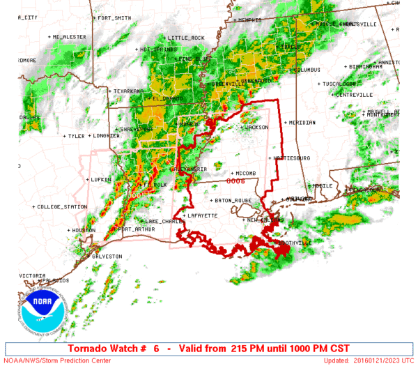
An “enhanced” severe weather risk continues over Southwest Alabama, with the standard “slight” risk as far north as Greene, Hale, and Perry Counties for tonight…
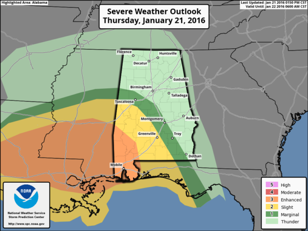
The core severe weather threat will be in the broad zone from Demopolis and Greensboro to Mobile and Atmore; some storms in that region could produce high winds, and an isolated tornado or two is very possible. The main threat for Alabama will come from about 6:00 p.m. through 3:00 a.m.
The severe weather threat for Tuscaloosa is marginal, and no severe storms are expected for Birmingham, Anniston, or Gadsden.
TOMORROW: Temperatures will fall during the day as a surface low pulls away from Alabama; we start the day in the 50s, and wind up in the 30s by mid to late afternoon. And, as the cold air rushes into the state, the lingering rain will change to light snow. NWS offices in Huntsville and Birmingham are now in the process of issuing “winter weather advisories” for the northern half of the state for tomorrow afternoon and tomorrow night.
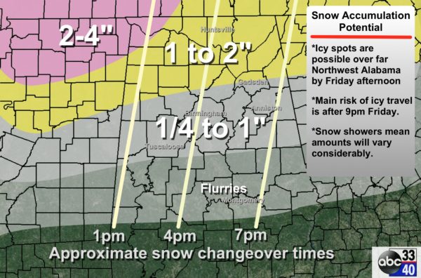
The heaviest snow is likely over the northwest corner of the state, elsewhere light amounts are likely. Since much of this wintry precipitation will fall in the form of snow showers, amounts will vary a good bit. Snow showers are like rain showers on summer afternoons; it can be very much hit and miss. Some communities will wind up with little if any snow; others will see the ground white. Generally speaking, amounts across North/Central Alabama will be in the 1/4 to 1 inch range.
TRAVEL: Icy spots could develop around the Shoals area tomorrow afternoon, but for most of the state the core risk of slick spots due to snow will come after 9:00 p.m. Temperatures probably won’t drop below freezing for places like Birmingham/Tuscaloosa/Anniston until after midnight tomorrow night.
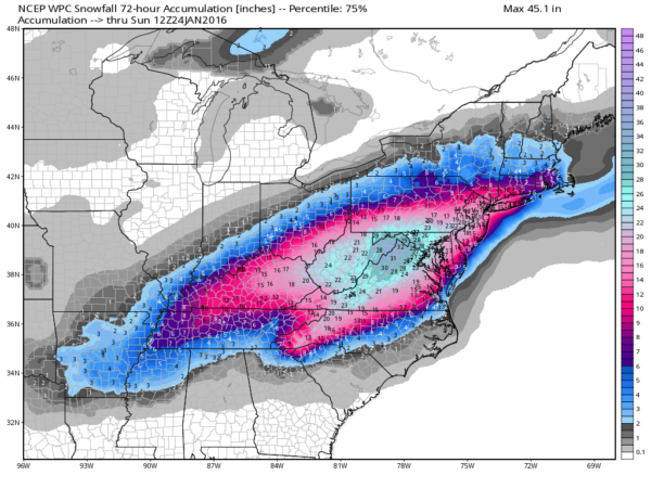
NORTHEAST OF ALABAMA: This will be a blockbuster, high impact snow storm for much of WV/VA/MD… with very significant icing possible in North Carolina where freezing rain will be more of a concern. Travel in these areas will become difficult, if not impossible by tomorrow afternoon and tomorrow night.
THE ALABAMA WEEKEND: Saturday will be breezy and cold with a mix of sun and clouds and a risk of morning flurries; we won’t get out of the 30s. Then, on Sunday, after a low well down in the 20s, we rise to near 50 degrees by afternoon with a good supply of sunshine.
WEATHER BRAINS: Don’t forget you can listen to our weekly 90 minute netcast anytime on the web, or on iTunes. This is the show all about weather featuring many familiar voices, including our meteorologists here at ABC 33/40.
CONNECT: You can find me on all of the major social networks…
Facebook
Twitter
Google Plus
Instagram
I had a great time today visiting with the students at Floyd Elementary in Gadsden… be looking for them on the Pepsi KIDCAM today at 5:00 on ABC 33/40 News! The next Weather Xtreme video will be posted here by 7:00 a.m. tomorrow…
Category: Alabama's Weather
About the Author (Author Profile)
James Spann is one of the most recognized and trusted television meteorologists in the industry. He holds the AMS CCM designation and television seals from the AMS and NWA. He is a past winner of the Broadcast Meteorologist of the Year from both professional organizations.Subscribe
If you enjoyed this article, subscribe to receive more just like it.


