

Watching Severe Storms to the West, Winter Weather Advisories Issued Here
Click image to enlarge.
A very powerful storm system is starting to come together this afternoon over the Gulf Coast Region. It will go onto become a historic storm for the Mid-Atlantic States, with a side swath of 18-24 inch snows from the Smoky Mountains of North Carolina through Roanoke VA and up I-81 through the Shenandoah Valley. The Blue Ridge Parkway will be buried in snow.
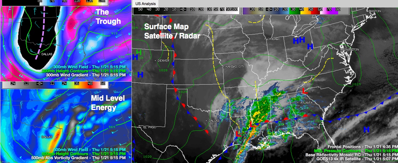
The surface low (1006mb) is located between Vicksburg and Jackson MS. The very deep upper trough extends from Minneapolis to Kansas City to Dallas at this hour. Upper winds ahead of the trough are diverging, or spreading apart, and this leads to rising motion.
Ahead of the surface low, a stationary front extends across South Central Mississippi, Alabama and Georgia. To the south of the front, temperatures are in the 60s with 70s over southern Louisiana.
The warm, moist air, aided by daytime sunshine that broke out, is combining with colder air aloft to produce moderate instability.
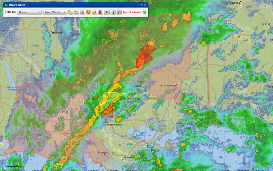
Current watches and warnings at 515 p.m.
Thunderstorms have broken out in this warm, moist airmass and have been very organized, with significant amounts of wind shear (50-60 knots). They have been severe, with numerous reports of hail. Wind damage has been reported near Alexandria LA and near Natchez MS. The storms have been prolific hail producers as well, with numerous reports of 1-1.75 inch hail across a long swath from near De Ridder LA to near Jackson MS.
A possible tornado was reported at 430 pm in Copiah County Mississippi. A tornado watch remains in effect for much of eastern Texas, Louisiana and southern Mississippi. More tornado watches will be issued later this evening into Southwest Alabama.
Now, as the storms approach the stationary front, they become elevated, meaning that their bases are well above the surface. This means that the rotation will likely stay aloft as well, and the tornado threat should diminish. But large hail will still be a threat.
ALABAMA TIMING AND IMPACT
These storms are moving ENE at 35-40 mph. They will reach western Alabama between 730 and 830 p.m. For areas south of a line from Aliceville to Moundville to Selma and points south, the storms could produce isolated severe weather reports. Further south, south of a line from Butler to Monroeville could produce more significant severe weather. Damaging winds and hail will be the highest threats, but there is a decent chance of a tornado in Southwest Alabama in counties like Choctaw, Clarke, Monroe, Escambia, Washington, Mobile and Baldwin.
Moderate to heavy rain will start overspreading West Alabama between 7-8 p.m. and will continue until after midnight. 1 to 2 inch rainfall amounts will be widespread. There is a flash flood watch for the Tennessee Valley.
BLOCKBUSTER STORM
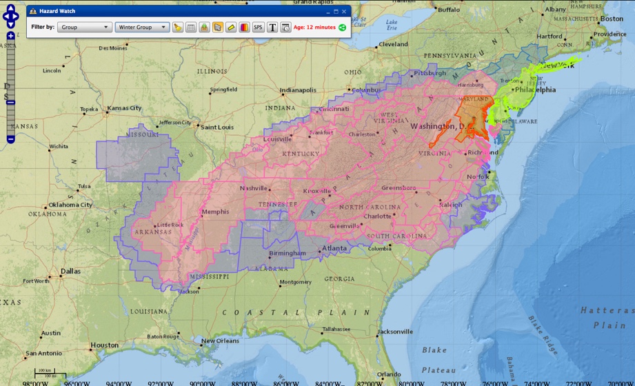
Winter weather advisories, winter storm watches and warnings and a blizzard warning!
This system will explode as impressive energy aloft helps to intensify the as it makes the turn up the East Coast later tonight. The blizzard watch has been upgraded to a blizzard warning for the D.C area, where up to 25 inches could fall inside the Beltway. If that happens, it could be the 2nd biggest snowstorm in the history of our nation’s capital. It certainly looks like it will easily be a top five storm.
WINTER WEATHER ADVISORIES ISSUED IN ALABAMA
As the big storms winds up and heads northeast, colder air will be drawn into Alabama and will combine with a large reservoir of leftover moisture over the southeast. The best accumulations of snow will extend across northern Tenenssee and Kentucky, wrapping back into northern North Carolina and up through West Virginia, Virginia, Maryland and the rest of the Mid-Atlantic.
But here in Alabama, we expect ¼ to 1 inch of snow across much of North Central Alabama, with some dustings as far south as Clanton or perhaps Montgomery. The Tennessee Valley could see 2-3 inches.
The NWS in Huntsville has issued a winter weather advisory starting at noon tomorrow for their northwestern counties (Colbert, Franklin, Lauderdale, Lawrence, and Limestone) and at 6 p.m. tomorrow for their northeast counties (Cullman, De Kalb, Jackson, Madison, Marshall, and Morgan). The advisories currently go until early Saturday morning.
The NWS in Birmingham has issued winter weather advisories starting at noon tomorrow and lasting until 6 a.m. Saturday for Blount, Calhoun, Cherokee, Clay, Cleburne, Etowah, Fayette, Jefferson, Lamar, Marion, Pickens, Shelby, St. Clair, Talladega, Tuscaloosa, Walker and Winston Counties.
Category: Alabama's Weather, Severe Weather, Winter Weather
About the Author (Author Profile)
Bill Murray is the President of The Weather Factory. He is the site's official weather historian and a weekend forecaster. He also anchors the site's severe weather coverage. Bill Murray is the proud holder of National Weather Association Digital Seal #0001 @wxhistorianSubscribe
If you enjoyed this article, subscribe to receive more just like it.


