

Mid-Morning Update
Here is a mid-morning update.
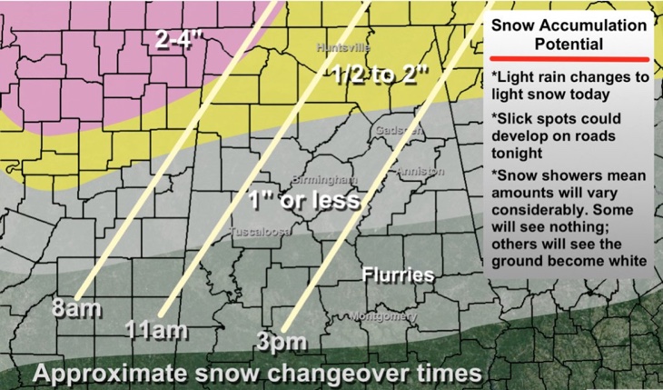
The forecast remains unchanged:
At this hour, light to moderate rain is pushing northeastward across North and Central Alabama. The surface low (1006mb) is just east of Birmingham. The rain is heaviest and most widespread north of the low in the US-278 corridor curving down into East Alabama round Anniston.
Another batch of moderate rain is pushing ENE across Perry, Dallas, Autauga, Montgomery and Elmore Counties.
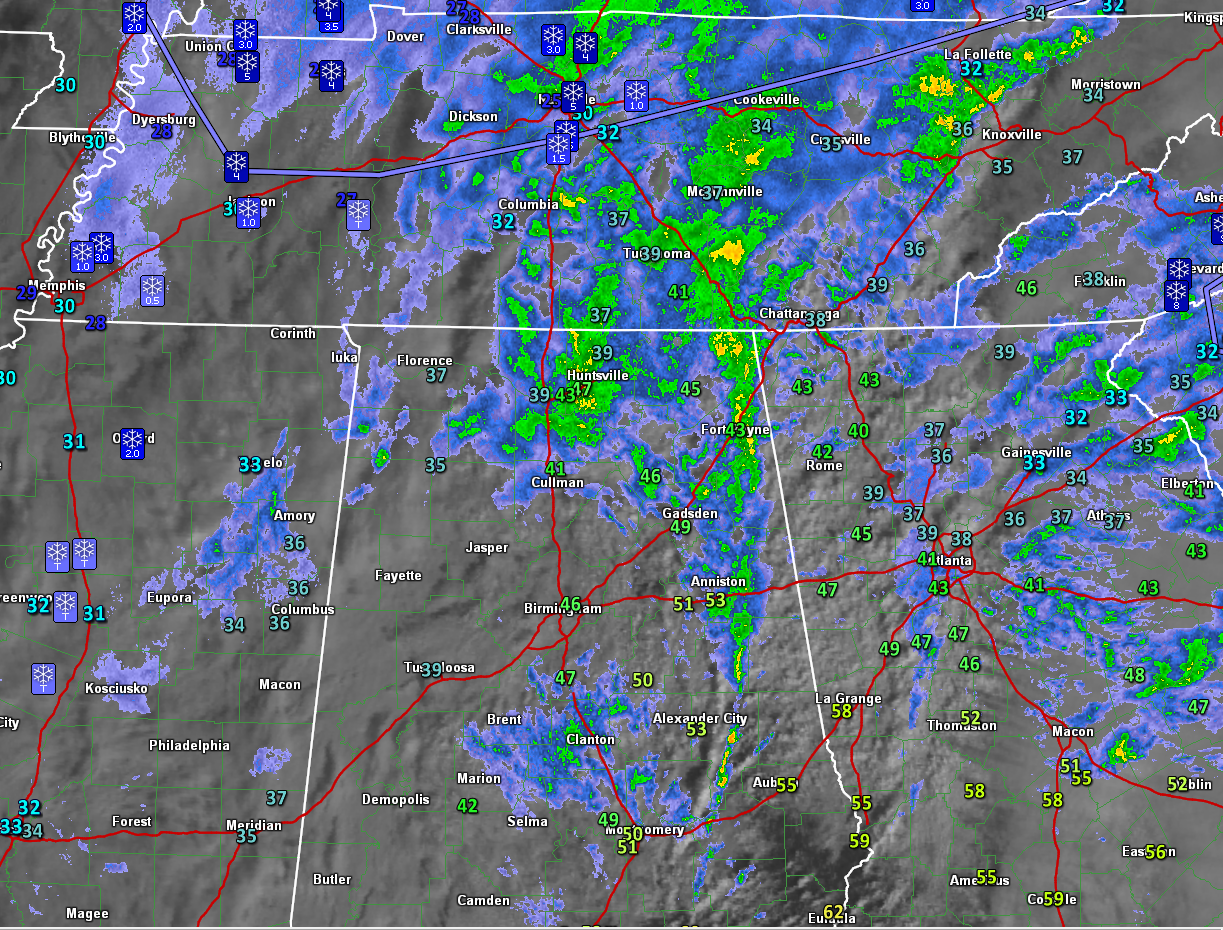
Here is the radar with surface temperatures and snow reports.
Lots of schools are dismissing early. Marion County will shut down at 11 a.m. Pickens County and Fort Payne Schools at 11:30. Cullman County at noon. Haleyville, Winston Co and Lamar Co at 11:30. Jasper City at 12:30. Check with your school system.
NORTH ALABAMA AND MISSISSIPPI
Temperatures are in the upper 40s and 50s southeast of I-59, with middle 40s east of I-65 over North Alabama. Readings have already fallen into the 30s over Northwest Alabama. It is 37 at Haleyville. It is already below freezing over northern Mississippi, with 32 at Batesville. There is 2 inches of snow on the ground at Oxford. There is 7 inches on the ground at Little Rock.
The heavier precipitation that produced this snowfall has diminished considerably in the past two hours.
While the snow over northern Mississippi has tapered off, snow is wrapping around the low back over western Tennessee and some of this will work its way into northern Mississippi and Northwest Alabama this afternoon.
Rain should change to light snow at Muscle Shoals and down through Franklin and Marion and Lamar Counties within the hour. Sleet and snow is already being reported in northern Lauderdale County. This part of Northwest Alabama could see up to 2 inches of snow.
The band of snow should reach Tuscaloosa by noon-12:30 and Jasper around 1 p.m.
It should reach the Birmingham and Cullman areas around 2 p.m. as a rain/snow mix and changeover to all snow. Temperatures should still be above freezing in the Birmingham area though and travel problems will be limited.
As for accumulations further south in places like Tuscaloosa, Birmingham and Anniston, it will take heavier snow bands to produce those. Snow was falling at Starkville but having a hard time sticking because it was light in nature and the ground is warm. This will be the story until temperatures come down and you get some heavier areas of snow.
That should happen this evening in areas east of I-65 as the big winter storm ramps up for the East Coast. Snow should wrap back down into areas east of I-65 after 6 p.m. and intensify. Areas north of I-20 and east of I-65
The NWS maintains a winter weather advisory for Pickens, Tuscaloosa, Jefferson, Shelby, Talladega, Clay and Randolph Counties and points north across the state. 1/4 to 1.5 inches of snow is expected in some locations in the advisory area, depending on where the snow bands fall.
QUICK ROUND UP AROUND THE REGION
…Nice snow in Nashville already. 3.5 inches reported in Belle Meade. 5 inches in East Nashville, and still snowing.
…Snow has been light in the Memphis area. 1 inch reported in Millington with 2-3 inches in Atoka.
…Not much over northern Mississippi, just that 2 inch report from Oxford .
…Already 6 inches this morning near Roanoke and Blacksburg in Virginia.
Category: Alabama's Weather, Winter Weather
About the Author (Author Profile)
Bill Murray is the President of The Weather Factory. He is the site's official weather historian and a weekend forecaster. He also anchors the site's severe weather coverage. Bill Murray is the proud holder of National Weather Association Digital Seal #0001 @wxhistorianSubscribe
If you enjoyed this article, subscribe to receive more just like it.


