

Severe Storms Possible Tuesday
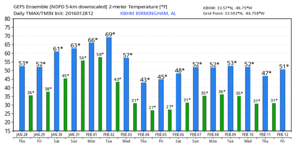
DRY THROUGH THE WEEKEND: A secondary surge of dry, continental air drops into Alabama tonight, and tomorrow should be much like today… ample sunshine with a high in the mid 50s.
Then, the weather turns spring-like for the weekend. Saturday will feature a sunny sky with a high in the mid 60s, and Sunday’s high will be very close to 70 degrees with a mix of sun and clouds. A few light showers could creep into North Alabama Sunday night ahead of a weak front.
Monday will stay very mild with a high around 70 with just a few scattered showers. But, eyes will be on a major storm system forming west of Alabama. Big snows are likely Monday for cities like Flagstaff, Denver, and Albuquerque, and as that system lifts out of the Southwest U.S., it will set the stage for an active severe weather day for parts of the southern U.S. Tuesday.
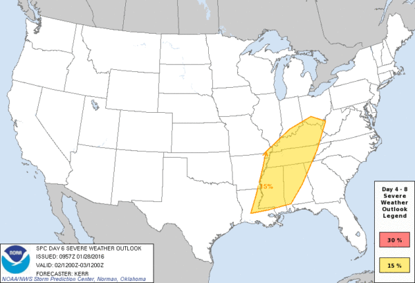
SPC continues to have much of Alabama in their “Day 6” severe weather outlook, which covers the 24 hour period from 6:00 a.m. CT Tuesday through 6:00 a.m. CT Wednesday.
Note the surge of unstable air up into Alabama; surface based CAPE values are expected to reach 1,000 j/kg Tuesday evening, pretty impressive for early February.
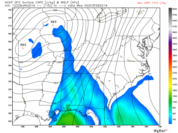
The bottom line is that there should be excellent dynamic and thermodynamic support for deep convection.
Please understand this risk is 5-6 days away, so it is just about impossible to get really specific. But, this is the current thinking…
*Strong to severe storms will be possible across North and Central Alabama Tuesday afternoon into Tuesday night. Storms will be capable of producing large hail, damaging winds, and a few tornadoes.
*The greatest threat of tornadoes will be in discrete cells that form ahead of the main squall line/QLCS, although a small tornado is possible within the line in close to line breaks and some bowing segments.
*Rain amounts of 1/2 to 1 inch are expected, not enough to bring widespread flooding problems.
Understand severe weather is fairly routine in Alabama; this is nothing “historic” or really out of the ordinary, but it certainly has potential to be a medium to high impact event, and we will watch developments closely in coming days.
LATER NEXT WEEK: Wednesday will be dry and cooler with highs back in the 50s, but even colder air arrives Thursday and Friday with highs in the 40s. Some North Alabama communities won’t get out of the 30s Thursday afternoon. See the Weather Xtreme video for maps, graphics, and more details…
WEATHER BRAINS: Don’t forget you can listen to our weekly 90 minute netcast anytime on the web, or on iTunes. This is the show all about weather featuring many familiar voices, including our meteorologists here at ABC 33/40.
CONNECT: You can find me on all of the major social networks…
Facebook
Twitter
Google Plus
Instagram
I had a great time today visiting with the students at Salter Elementary in Talladega… be looking for them on the Pepsi KIDCAM today at 5:00 on ABC 33/40 News! Also, thanks to the senior adults at First Baptist of White Plains for their very kind hospitality today and a great lunch! Look for the next Weather Xtreme video here by 7:00 a.m. tomorrow…
Category: Alabama's Weather
About the Author (Author Profile)
James Spann is one of the most recognized and trusted television meteorologists in the industry. He holds the AMS CCM designation and television seals from the AMS and NWA. He is a past winner of the Broadcast Meteorologist of the Year from both professional organizations.Subscribe
If you enjoyed this article, subscribe to receive more just like it.


