

Warmer Days Ahead; Severe Storms Tuesday
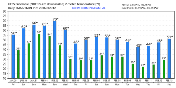
BLUE SKY: Hard to find a decent cloud in the Alabama sky this afternoon across the great state of Alabama; temperatures are mostly in the mid to upper 50s; a few spots over West Alabama have reached the low 60s.
Tomorrow will be dry and even warmer with a high up in the mid 60s, and a few communities could reach 70 degrees by Sunday. There will be a gradual increase in clouds Sunday, and a few showers could reach North Alabama Sunday night ahead of a weak front.
Monday will be mostly cloudy and mild with a chance of scattered showers and a high around 70 degrees.
SEVERE WEATHER THREAT TUESDAY: SPC has an enhanced severe weather threat Tuesday afternoon and Tuesday night over Northwest Alabama, with the standard risk down to near Mobile…
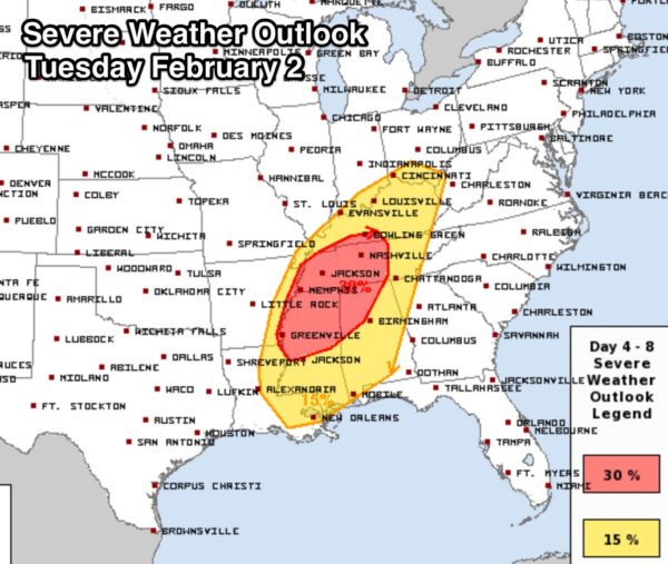
New guidance this morning continues to point to a potential high impact severe weather threat for a decent part of Alabama. Surface based CAPE values surge to 1,000 j/kg Tuesday afternoon, more than enough instability for severe storms, and a dynamic upper trough will produce excellent diffluence aloft and strong lapse rates. And, a deepening surface low will move through Missouri, into Illinois, with high bulk shear values over the region. And, wind fields at the surface and aloft will be moderate to strong.
This is our latest thinking…
TIMING: The core threat of severe storms will come from 3:00 p.m. Tuesday through 12:00 midnight Tuesday night. Please note this event is still 4-5 days away, and the timing could change.
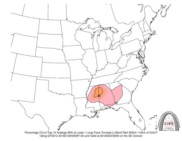
MODES: All severe weather modes will be possible, including large hail and damaging winds. The highest tornado threat will come from discrete storms that form Tuesday afternoon across North and West Alabama, in the SPC “30% area”. We do note that analogs (looking at past weather events under similar meteorological patterns) suggest that one or two long track tornadoes will be possible in this area as well. By Tuesday night the threat will shift to mainly straight line winds from the passing line of storms.
RAIN: Rain amounts of 1/2 to 1 inch are likely; flooding is not expected.
GRADIENT WINDS: Even away from thunderstorms, it will be windy with south winds of 15-25 mph, gusting to 30 mph at times.
CALL TO ACTION: Just be sure you have a way of hearing warnings, and think about where you go if you do happen to fall under a tornado warning polygon. And, don’t forget your readiness kit in that safe place with things like helmets for everyone, whistles or air horns (if you need to get the attention of first responders), and hard sole shoes.
And, considering passing along knowledge of the threat Tuesday to people that don’t usually pay attention to weather.
Interesting to note one of the top analogs that shows up is the “Super Tuesday” tornado outbreak of February 5-6, 2008…. that one produced 57 tornadoes, and the death toll was 57 in states mostly just north and west of Alabama.
REST OF NEXT WEEK: Clouds linger Wednesday, and we turn colder, and the rest of the week looks cold and dry. See the Weather Xtreme video for maps, graphics, and more details.
WEATHER BRAINS: Don’t forget you can listen to our weekly 90 minute netcast anytime on the web, or on iTunes. This is the show all about weather featuring many familiar voices, including our meteorologists here at ABC 33/40.
CONNECT: You can find me on all of the major social networks…
Facebook
Twitter
Google Plus
Instagram
I had a great time today seeing the kids at Vernon Intermediate School in Lamar County… be looking for them on the Pepsi KIDCAM today at 5:00 on ABC 33/40 News! My next Weather Xtreme video will be posted here by Monday morning at 7:00… Bill Murray will have the video updates tomorrow and Sunday. Enjoy the weekend!
Category: Alabama's Weather
About the Author (Author Profile)
James Spann is one of the most recognized and trusted television meteorologists in the industry. He holds the AMS CCM designation and television seals from the AMS and NWA. He is a past winner of the Broadcast Meteorologist of the Year from both professional organizations.Subscribe
If you enjoyed this article, subscribe to receive more just like it.


