

Very Nice Weekend; Latest on Tuesday Severe Weather Threat
Perhaps a little good news in the severe weather department about the upcoming event which will be in here on Tuesday, but we’re not out of the woods with this very dynamic system. Let’s dig into the details.
NICE WEEKEND IN STORE: After a nice day on Friday with highs in the upper 50s and lower 60s, today and Sunday promise to be blockbuster days for late January with a good supply of sunshine both days and highs in the upper 60s. There will even be a few 70F+ readings on Sunday, especially down around Demopolis, Selma and Montgomery. A weakening cold front will push toward the area Sunday night, triggering a few showers across the area, but rainfall amounts and coverages will be low. Lows tonight will be in the 40s and in the 50s Sunday night.
SETTING THE STAGE: By Monday, that front will be falling apart and a powerful upper level system will be getting its act together over the western U.S. and a surface low will be preparing to move out onto the Plains. Big time snows will fall over parts of Utah, Colorado, Arizona and New Mexico, which is great news for the skiers, but bad news for those of us ahead of the system in the warm sector of the low, because that means thunderstorms.
SEVERE WEATHER THREAT: Overnight runs of our global models have trended slower and less unstable, especially for us here in Alabama. Warmer air aloft means less instability and the system arriving later in the evening Tuesday night would be well after the peak heating of the day, meaning less volatile conditions. This is encouraging that the system might not be as high impact as we have been thinking, but it still will be a severe weather producer for us in the state.
SPC SHIFTS HIGHEST RISKS SLIGHTLY WEST: The SPC has shifted the highest probabilities for severe weather a little west, pushing the 30% probability back over West Central and Northwest Alabama, from Lamar and Pickens Counties up through the northwestern part of the state then into western Tennessee and Mississippi.
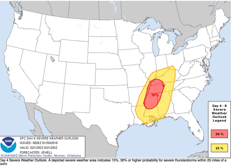
Having said that, nearly all of Central Alabama is still in the standard “slight” risk for severe weather according to the SPC. It looks like the showers and storms will break out over Arkansas and Louisiana late Tuesday morning and will push east. They should get into western Alabama in the 6-9 p.m. time frame and will push across the state during the evening hours. This 6 hour delay could make a big difference in the instabilities. The latest model runs have trended more in the 500 joule/kg range, instead of over 1,000 joules.
Still, the system is very dyanmic A 130 knot+ jet streak (at 200 mb) is forecast to move over the region, and the low level jet (5,000 feet/850 mb) will exceed 60 knots over North Alabama. Storm relative helicity values will be high, and LCL values low (Lifted Condensation Level). Bottom line is that both dynamic and thermodynamic profiles will be very supportive of severe storms here.
So, here is the latest thinking:
*There will be a risk of strong to severe thunderstorms over much of Alabama Tuesday evening. For North/Central Alabama, highest risk will come from roughly 6:00 p.m. until 3:00 a.m.
*All modes of severe weather are possible, including large hail, damaging winds, and a few tornadoes.
*The highest risk of a tornado will be roughly over Lamar, Pickens, Marion, Franklin, Colbert, Lauderdale and Lawrence Counties in the “30 percent enhanced” area as defined by SPC, and in discrete storms that manage to form during the afternoon and evening hours ahead of the main squall line/QLCS.
*Rain amounts of around 1 inch are likely, and flooding is not expected to be an issue.
No need to be worried or anxious; we have a number of severe weather threats every year in Alabama. It has just been unusually quiet in recent years. And, remember, this is still 5 days out and the forecast can change.
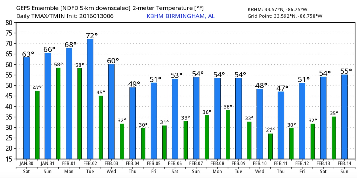
REST OF NEXT WEEK: Colder air rolls into the state over the latter part of next week, with highs dropping generally in the 40s. Here are temperature trends from the GFS ensembles:
See the Weather Xtreme video for maps, graphics, and more details.
I will be back with another Weather Xtreme video tomorrow morning. We will have updates throughout the weekend on the blog.
Category: Alabama's Weather
About the Author (Author Profile)
Bill Murray is the President of The Weather Factory. He is the site's official weather historian and a weekend forecaster. He also anchors the site's severe weather coverage. Bill Murray is the proud holder of National Weather Association Digital Seal #0001 @wxhistorianSubscribe
If you enjoyed this article, subscribe to receive more just like it.


