

Still Have Severe Weather Threat on the Board For Tuesday
We continue to search for clues about the severe weather event that will impact Alabama on Tuesday. After days of run-to-run consistency among the global models, things have gotten a little fuzzier as we have gotten closer to the event. It appears that the threat of significant tornadoes has lessened somewhat for us here in Alabama, with the exception of the northwest part of the state. But the main message is that we still have a rather significant severe weather event looming for us Tuesday afternoon into Tuesday night here in Central Alabama.
BEAUTIFUL SATURDAY: One thing that is certain is that Saturday was a beautiful day across Central Alabama. Highs ranged from 68F at Birmingham to 69F at Anniston and Calera to 70F at Tuscaloosa. Montgomery managed to hit 71F.
MILD SUNDAY: High pressure is centered east of Charleston SC this morning. It is stubbornly strong. A surface low is over central Missouri. Alabama has been feeling itself in the increasing pinch between these two systems overnight, and southerly winds have been increasing. This kept readings west of I-65 above 50F through the overnight hours. Lows over eastern Alabama were in the 40s. Clouds increased as moisture levels rose as well and there will be more clouds than sun today, but this won’t keep the mercury from reaching the upper 60s to lower 70s. The low will drop to the southeast along the Red River and then east northeast toward Memphis. A few showers could break out across the area this afternoon, but that chance is small. Rain chances will increase tonight, but the chance you will see rain is about 1 in 3.
MONDAY: Monday will start off mostly cloudy with a few showers. Temperatures will be in the middle 50s. There will be some clearing during the day, and highs will top out near 70F.
TUESDAY MORNING: We will be tracking an intensifying surface low near Kansas City. Southerly winds will be increasing over Alabama and as moisture levels surge, dewpoints will rise into the 60s, making it feel quite humid. Showers and thunderstorms will break out over Louisiana and Arkansas during the day. A line of thunderstorms will push into Alabama during the evening. After believing earlier that instability would not be a question, that is not so certain now. Wind shear certainly will not be a question. Let’s look at some parameters:

INSTABILITY: Temperatures will be in the lower 70s and dewpoints in the lower 60s. The GFS and SREF are only indicating about 250 j/kg of CAPE in the 3 p.m. to midnight window. This is sufficient to produce thunderstorm updrafts, but they won’t be intense. Lapse rates, or decreasing temperature with height will be generally weak.
WIND SHEAR: The overall wind shear needed for organized thunderstorms will certainly not be lacking as bulk shear values will be over 60 knots. Low level helicity will be very high as well. The GFS and NAM rate it at over 400 m2/s2, which is almost too high for the weak instability that we will see.
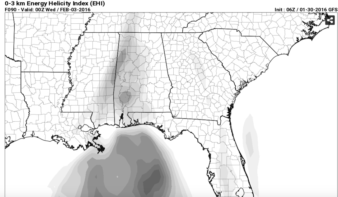
COMPOSITE PARAMETERS: The Energy Helicity Index needs to be over 1 for significant severe weather, and it is less than that on the latest run of the GFS, but the NAM brings the system in a little earlier and depicts an EHI of 1 over West Central Alabama Tuesday afternoon. The Significant Tornado Parameter is greater than 1 over Central Mississippi at mid-afternoon and nearly 2 over northern Mississippi by sunset, but weakens afterwards. One thing to note is that the lifted condensation level is low enough not to pose a hindrance to tornado formation.
ANOTHER FLY IN THE OINTMENT: The NAM indicates there could be fairly widespread showers and storms during the day, which could limit the severe weather threat except for the damaging wind threat overnight as the squall line arrives.
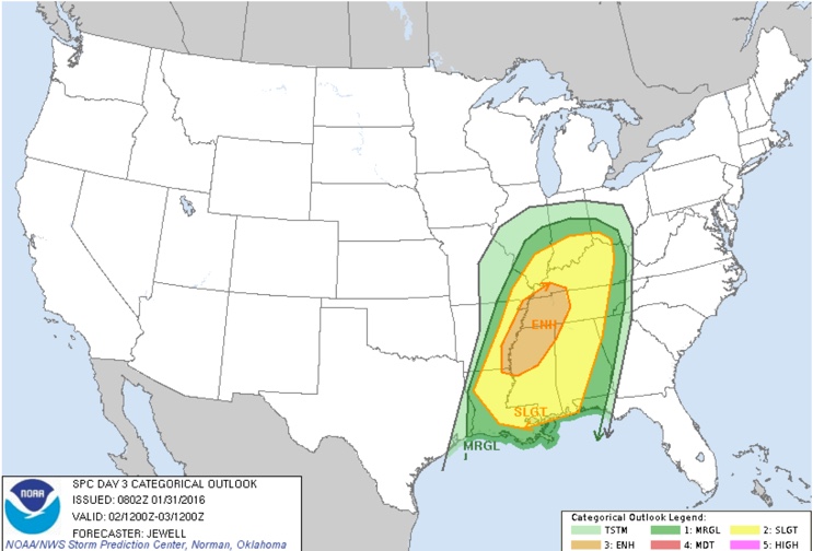
All of this weather geekiness indicates that the tornado threat has been reduced for Alabama. But with those helicity values, and the uncertainty about the instability, we can’t let our guard down just yet. Here is the new Day Three Severe Weather Outlook from the Storm Prediction center. It shows the best chance for severe weather over areas to our northwest, down into extreme Northwest Alabama’s Lauderdale, Colbert, Franklin and Marion Counties.
REVIEW YOUR SAFETY PLAN: Go over your personal safety plan for your home and business. Have a way of receiving weather warnings reliably, even while you sleep. Know what to do wherever you might be if a warning is issued. And tell others who might not be interested in weather about the potential threat. Don’t be anxious, just be prepared in case.

MIDWEEK AND BEYOND: The rain and storms will move out Wednesday morning and cooler and drier air will settle into Alabama for the remainder of the week and weekend. Highs will be in the 50s and lows in the 30s.
Category: Alabama's Weather, Severe Weather
About the Author (Author Profile)
Bill Murray is the President of The Weather Factory. He is the site's official weather historian and a weekend forecaster. He also anchors the site's severe weather coverage. Bill Murray is the proud holder of National Weather Association Digital Seal #0001 @wxhistorianSubscribe
If you enjoyed this article, subscribe to receive more just like it.


