

Late Night Thoughts on Tuesday Evening
The evening run of the North American Mesoscale Model has increased concerns for the possibility of severe weather, including tornadoes over Central Alabama early Tuesday evening. Early looks at the GFS are not quite as bullish, but also indicate the possibility for severe weather a little earlier, just after sunset over North Central Alabama. This is still a developing weather situation and one we will have to watch very closely during the day on Monday and into Tuesday.
Let’s discuss some severe weather parameters and what you might can expect.
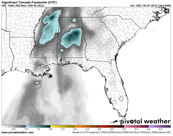
INSTABILITY: Temperatures will be in the lower 70s and dewpoints in the lower 60s. The general thinking over the past few model runs has been that instability would be low, less than 500 joule/kg, but we note that the evening run of the NAM is more bullish on instability, which ramps up the severe weather threat for any storms that form ahead of the main line of storms. The evening run of the NAM shows a little higher instability by 6 – 7 p.m. at Birmingham and shows an Energy Helicity Index of over 2, which is indicative of a more significant severe weather threat. It also ramps the Significant Tornado Parameter up over 1.5 across Central Alabama near and south of Birmingham. If these trends continue, it would increase our concern that there could be supercells and tornadoes ahead of the main line early in the evening.
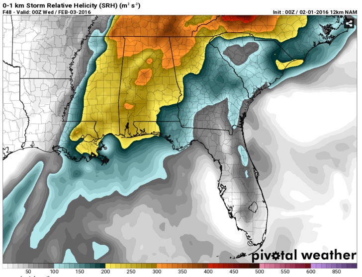
WIND SHEAR: The overall wind shear needed for organized thunderstorms will certainly not be lacking as bulk shear values will be over 60 knots. Low level helicity will be very high as well. The GFS and NAM rate it at over 400 m2/s2, which will overcome the low instability to produce a few tornadoes in the risk area, and especially in the enhanced risk area over Northwest Alabama, northern Mississippi, western Tennessee, southern Kentucky and extreme eastern Arkansas.
MODES OF SEVERE WEATHER: Damaging winds will be the main threat, but there will also be a few tornadoes. The greatest threat of tornadoes appears to be over Northwest Alabama’s Lauderdale, Colbert, Franklin and Marion Counties, but these new numbers from the NAM increase the concern that tornadoes could be possible early in the evening over Central Alabama. The chance of hail is rather unclear now.
TIMING: Showers and thunderstorms will fire near the Mississippi River around noon on Tuesday. The line of storms should reach the Northwest Corner of Alabama between 6-8 p.m. It should reach Huntsville, Jasper and Tuscaloosa around 11 p.m. to midnight. It should reach Birmingham sometime around 1-2 am. and Anniston around 4 a.m. We will be watching for storms to form ahead of the main line during the late afternoon and early evening. These could also produce damaging winds and tornadoes.
HEAVY RAIN THREAT: The approaching system will be a relatively slow mover, with about 6-8 hours of moderate to heavy rainfall across Central Alabama. It now appears that rainfall amounts could approach 2 inches over that time period. It appears that most locations can absorb that quantity of arainfall without major concerns, but localized flooding will be a very real possibility.
REVIEW YOUR SAFETY PLAN: Go over your personal safety plan for your home and business. Have a way of receiving weather warnings reliably, even while you sleep. Know what to do wherever you might be if a warning is issued. And tell others who might not be interested in weather about the potential threat. Don’t be anxious, just be prepared in case.
Category: Alabama's Weather, Severe Weather
About the Author (Author Profile)
Bill Murray is the President of The Weather Factory. He is the site's official weather historian and a weekend forecaster. He also anchors the site's severe weather coverage. Bill Murray is the proud holder of National Weather Association Digital Seal #0001 @wxhistorianSubscribe
If you enjoyed this article, subscribe to receive more just like it.


