

Severe Weather Threat Later Today/Tonight
THIS MORNING: Temperatures are in the low 60s across much of North/Central Alabama early this morning; the sky is mostly cloudy, and not much is showing on radar.
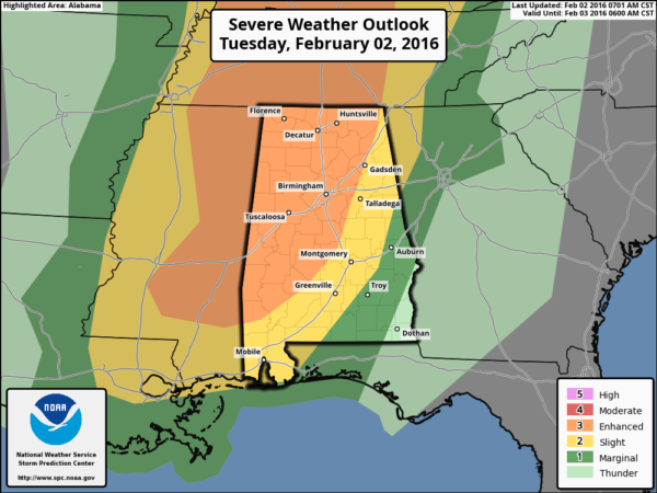
Scattered showers could form later this morning and early this afternoon, but the focus of this discussion is on the severe weather threat for Alabama late today and tonight. SPC has expanded the “enhanced risk” of severe weather on their new severe weather outlook for today…
I would say the threat is still not clear cut, limiting factors include weak lapse rates, and warmer air aloft in the 15,000-20,000 foot range that could keep instability values low. But, while the thermodynamics are questionable, the dynamics are certainly robust for severe weather with a strong low level jet and significant bulk shear values.
PLACEMENT/MODES: The highest risk of a tornado will come over that “enhanced” risk area late this afternoon and early tonight (west of a line from Scottsboro to Birmingham to Thomasville), but the risk of a tornado to the east over the “slight” risk is certainly not zero. Perhaps the greatest risk tonight is from strong, possibly damaging straight line winds as line of storms evolves. Stronger storms are also capable of producing some hail.
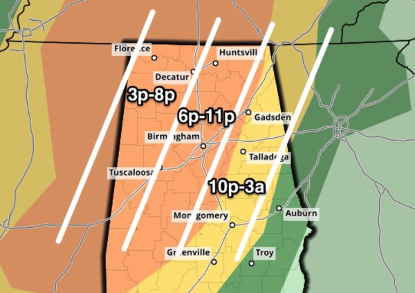
TIMING: A few discrete storms could form over West Alabama after 3:00 p.m… the core threat for the state will run from the early evening through the late night hours, although the severe weather threat will fade after midnight as the main dynamic support lifts away, and the air becomes more stable.
RAIN: Rain totals could approach two inches in some spots, and some isolated flooding problems are not out of the question.
GRADIENT WINDS: Away from storms, south winds will gust to 25/30 mph at times this evening. A wind advisory is in effect for the northern two-thirds of Alabama.
CALL TO ACTION: As always, be sure you are in a position to hear warnings if they are needed, have a plan of action, and a readiness kit in your safe place. See this post I wrote before Christmas on specific things to do.
TOMORROW: Rain ends tomorrow morning, and we should begin to see some clearing tomorrow afternoon as drier air works into the state; still pretty pleasant with a high in the low to mid 60s.
THURSDAY/FRIDAY: These two days will be cool and dry. Coldest morning will come early Friday when upper 20s are likely… highs will be in the low to mid 50s.
THE ALABAMA WEEKEND: Saturday stays cool and dry with a high in the 50s… then on Sunday a surface low will pass south of here; this feature should push clouds into the state, and some light rain is possible, mainly south and east of Birmingham. Parts of North Alabama could hold in the 40s all day Sunday.
NEXT WEEK: A pretty good cold shot is due in here by mid-week; we might have a hard time getting out of the 30s Wednesday or Thursday… see the Weather Xtreme video for maps, graphics, and more details.
WEATHER BRAINS: Don’t forget you can listen to our weekly 90 minute netcast anytime on the web, or on iTunes. This is the show all about weather featuring many familiar voices, including our meteorologists here at ABC 33/40. Scroll down for the show notes on the new episode we recorded last night.
CONNECT: You can find me on all of the major social networks…
Facebook
Twitter
Google Plus
Instagram
Stay tuned to the blog for updates on the severe weather situation through the day…
Category: Alabama's Weather
About the Author (Author Profile)
James Spann is one of the most recognized and trusted television meteorologists in the industry. He holds the AMS CCM designation and television seals from the AMS and NWA. He is a past winner of the Broadcast Meteorologist of the Year from both professional organizations.Subscribe
If you enjoyed this article, subscribe to receive more just like it.


