

Storms Have Already Formed Over Northwest Alabama
Good morning!
We are settling in for a long day and night of monitoring severe weather here at AlabamaWX. We will have frequent updates throughout the day of the thinking about the meteorology and of course a running account of developments as soon as watches and warnings happen.
Click image to enlarge.
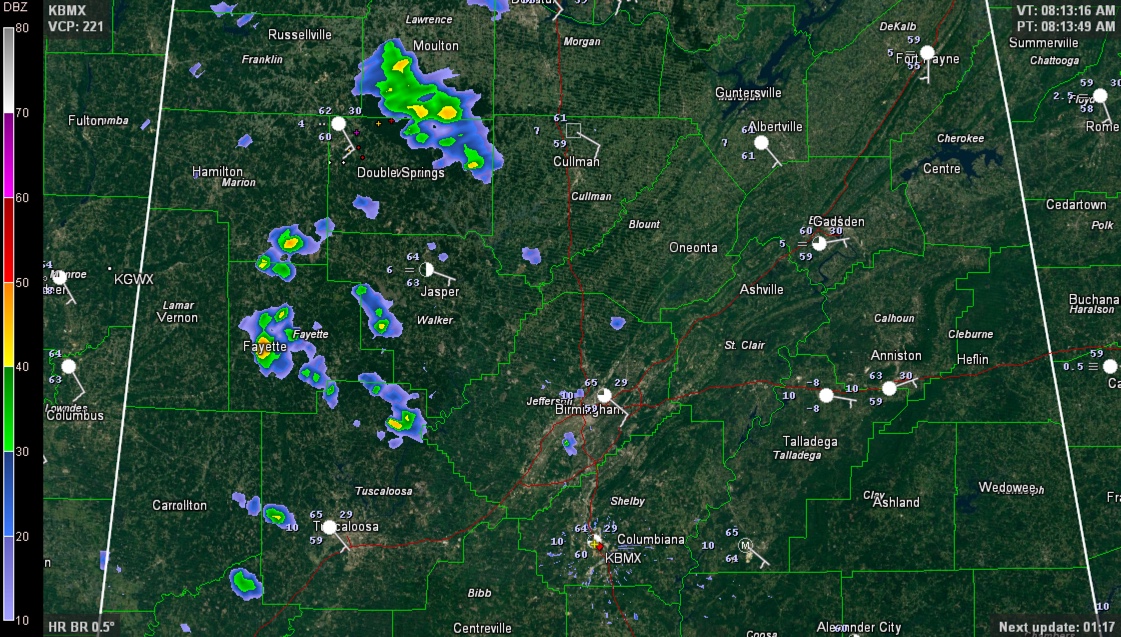
Showers and storms have already formed over Northwest Alabama this morning near a northward lifting warm front in an area of deep moisture convergence in the low levels of the atmosphere. When air comes together near the surface (converges) and diverges aloft, you get lift. The air piles up and has to go somewhere. The result is showers and storms.
One storm formed over northern Lamar and Fayette Counties about 7:15 and pushed across Marion County. It is now over Winston County between Haleyville and Double Springs.
It is mild and increasingly humid over Central Alabama. Dewpoints are already in the upper 50s, approaching 60F. The DP at Meridian is 63F and 66F at Jackson MS. Temperatures are in the middle 60s.
Showers and some thunder will continue over West Alabama through the morning, but that will not pose a severe threat.
Showers and storms will fire over northern Mississippi into southern Tennesse by late morning and will move into western Kentucky later. These will pose a significant severe threat, including the possibility of a couple of strong tornadoes as well as damaging winds.
For us, the first of two main threats will come just after midafternoon, when storms start forming in the unstable airmass over Central and eastern Mississippi. These storms will push into West Central Alabama starting about 4-5 p.m. and will continue into the late evening. They will have the potential to also produce damaging winds and a couple of strong tornadoes.
The final threat will last the longest as a line of thunderstorms enters West Alabama starting around 9-11 p.m., congeals with the ongoing storms across that part of the state and pushes across the rest of the area during the night. This activity should clear the Hamilton area around midnight, the Jasper/Tuscaloosa/Cullman areas around 1-3 a.m., the Birmingham/Gadsden around 2-4 a.m. and the Anniston/Alex City area around 5-7 a.m. It should finally clear Auburn around 7-9 a.m.
We have said it so many times in the past 7 days. Assess your severe weather safety plan and go over it with your family and co-workers. Monitor the weather throughout the day and night and have a way to receive warnings. Think about where you will be during the threat times this afternoon and tonight and know where you would go if a warning was issued whether that is at work, home or anywhere else. Plan your travel so it does not coincide with the time that severe weather is expected.
Don’t be alarmed. Be informed. Knowledge is the best antidote to a fear of severe weather.
Stay with us here at AlabamaWX throughout the day for the very latest on the developing weather situation.
Category: Alabama's Weather, Severe Weather
About the Author (Author Profile)
Bill Murray is the President of The Weather Factory. He is the site's official weather historian and a weekend forecaster. He also anchors the site's severe weather coverage. Bill Murray is the proud holder of National Weather Association Digital Seal #0001 @wxhistorianSubscribe
If you enjoyed this article, subscribe to receive more just like it.


